Download
1 / 22
230 likes | 572 Vues
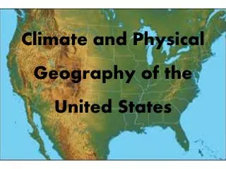
Physical Geography of the United States and Canada: A Land of Contrasts. North America’s vast land and varied landscape and abundant resources have attracted immigrants and shaped the development of the United States and Canada. Section 1 Landforms and Resources.

E N D
Physical Geography of the United States and Canada: A Land of Contrasts North America’s vast land and varied landscape and abundant resources have attracted immigrants and shaped the development of the United States and Canada
Section 1Landforms and Resources • The United States and Canada have vast lands and abundant resources • These two countries share many of the same landforms
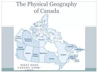
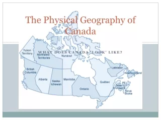
Landscape Influenced Development • Anglo America • US, Canada: former British colonies, most people speak English • Strong economic and political ties with one another • Mexico is part of Latin America NOT Anglo America • Vast Lands • Canada is the 2nd largest country in the world by area; US is the 3rd largest • Together they cover 1/8th of the earth’s land surface
Landscape Influenced Development • Abundant Resources • Landmass and natural resources attract immigrants to both countries • US and Canada have developed into global economic powers • The 2 resources that helped the US and Canada develop into Global Economic Powers: • Fertile soil, water, forest, minerals
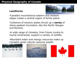
Many and Varied Landforms • Major Landforms • All major landforms are found in the US and Canada • The two countries share mountain chains and interior plains • The Eastern Lowlands • Atlantic Coastal Plain extends from Delaware down to Florida • Gulf Coastal Plain goes from Florida, along Gulf of Mexico to Texas • Piedmont – low plateau between coastal plains, Appalachian Highlands
Many and Varied Landforms • The Appalachian Highlands – Eastern Mountain Chain • Appalachian Mountains run 1,600 miles from Newfoundland to Alabama • Include Green and Catskill mountains in the north • Blue Ridge and Great Smoky mountain in the south • More than 400 million years old • Erosion has created gentle slopes, peaks from 1,200 to 2,400 feet • The Appalachian Trail is a scenic hiking path along the chain.
Many and Varied Landforms • The Interior Lowlands • Glaciers leveled the land, left fertile soil • Interior Plains extend from Appalachian to Missouri River • Great Plains extend from Missouri to Rocky Mountains • Canadian Shield – vast, flat area around Hudson Bay
Great Plains • Mostly treeless area • 4,000 feet above sea level • Run through Southern Texas up through Southern Canada
Canadian Shield • Rocky Flat Region • Lies far north in Canada • Covers about 18 million square miles • Encircles Hudson Bay
Many and Varied Landforms • The Western Mountains, Plateaus, and Basins • Rocky Mountains run 3,000 miles from Alaska to New Mexico • Relatively young: 80 million years old • Less erosion mean rugged, 12,000-foot, snow-covered peaks • Continental Divide – the line of highest point along the Rockies • Separates rivers that flow eastward from those that flow westward
Many and Varied Landforms • The Western Mountains, Plateaus, and Basins • Other Pacific mountain ranges: Sierra Nevada, Cascade • Continent’s highest peak: Mt. McKinley in Alaska • Major earthquake activity in Pacific ranges • Between ranges and Rockies: cliffs, canyons basins
Many and Varied Landforms • The Islands • Canada’s large, northern islands: Ellesmere, Victoria, Baffin • US: Aleutians (Alaska), Hawaiian (politically, not geographically)
Resources Shape Ways of Life • Oceans and Waterways • US and Canada are bounded by: • ATLANTIC, PACIFIC, ARTIC OCEANS • GULF OF MEXICO • Countries have many large, inland rivers and lakes that provide: • Transportation, hydroelectric power, irrigation, fresh water, fisheries
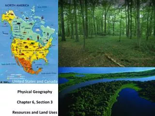
Resources Shape Ways of Life • Oceans and Waterways • Great Lakes: HURON, ONTARIO, MICHIGAN, ERIE, AND SUPERIOR • Mississippi-Missouri-Ohio river system: continent’s longest, busiest river • Mackenzie River: longest in Canada, crosses Northwest Territories • Land and Forest • Fertile soil helps make North America world’s leading food exporter • Large forests yield lumber and other products • ½ of Canada and 1/3 of US is covered by FOREST!
Resources Shape Ways of Life • Minerals and Fossil Fuels • Mineral quantity and variety make rapid industrialization possible • Canadian Shield: iron ore, nickel, copper, gold, uranium • Appalachians, Great Plains: COAL • Gulf of Mexico: oil natural gas • US: biggest energy consumer; gets most of Canada’s energy exports • NATURAL RESOURCES FOUND: • Iron Ore, Nickel, Copper, Gold, Uranium, Silver, coal, natural gas, oil