Download
1 / 12
120 likes | 275 Vues
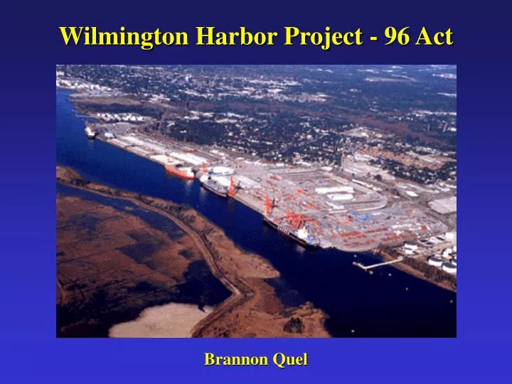
Wilmington Harbor Project - 96 Act. Brannon Quel. Port of Wilmington. The Cape Fear River serves as the shipping channel to the State Port in Wilmington, NC. Located 26 miles from the sea. Last year the Port of Wilmington handled 2,266,000 tons of cargo

E N D
Wilmington Harbor Project - 96 Act Brannon Quel
Port of Wilmington • The Cape Fear River serves as the shipping channel to the State Port in Wilmington, NC. • Located 26 miles from the sea. • Last year the Port of Wilmington handled 2,266,000 tons of cargo • The Port system of North Carolina is responsible for 80,000 and creates ~$300,000,000 in tax revenue statewide. • Existing Dimensions: Ocean bar channel depth of 40 ft. at M.L.W. and width of 500 ft. Inside harbor channel depth of 38 ft. and M.L.W. and width of 400 ft. • Presently, fully loaded ships cannot come to the port since they draw too much water.
Project Overview • Due to the the limits and logistics of a harbor 26 miles up the Cape Fear River, the Port of Wilmington has not been able to compete with the neighboring Port of Charleston. • The $5.2 billion Water Resources Development Act of 1996 made provisions for the widening and deepening of the Cape Fear River to the Port of Wilmington - The Wilmington Harbor Project 96 - Act • The estimated cost for the project is $377 million and will be split between federal (66%) and state funds (33%). The project is expected to be completed by 2005.
Channel Improvements • 37 miles of channel will be dredged. • The channel will be deepened by 4 feet (MLW) • Ocean bar channel will go from 40 ft. to 44ft., the river channel will increase from 38 ft. to 42 ft. The Northeast Cape Fear River will be deepened from 35 ft. to 38 ft. • A 6.2 mile passing lane will be added in front of Sunny Point Military Ocean Terminal. • 27 mcy of material will be dredged, 1.5 mcy of rock.
Channel Realignment • The channel entrance will be realigned to avoid dredging rock in the existing channel • This will eliminate the need to blast 2,000,000 cubic yards of rock and save an estimated $40,000,000. • However, the new alignment will move the channel over the current Ocean Dredged Material Disposal Site (ODMDS). • There will now be the need to move the ODMDS and there will be an surplus of 5,600,000 cubic yards of beach quality sand to deal with!
What to do with all the sand? a.k.a. The Brunswick Beaches Consortium Holden Beach Oak Island Caswell Beach Bald Head Island
References http://starnews.wilmington.net/local/newhanover/22808.htm http://www.brunswickbeaches.org/index2.html http://www.ncports.com http://www.saw.usace.army.mil/domino/CESAW.nsf http://www.usace.army.mil/inet/functions/cw/cecwa/wrdasxs.htm http://www.villagebhi.org/