Download
1 / 1
10 likes | 137 Vues
Approximating Terrain with Over-Determined Laplacian PDEs. Abstract :

E N D
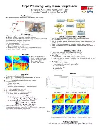
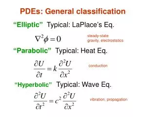
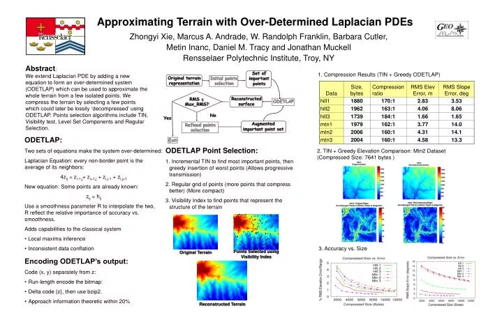
Approximating Terrain with Over-Determined Laplacian PDEs Abstract: We extend Laplacian PDE by adding a new equation to form an over-determined system (ODETLAP) which can be used to approximate the whole terrain from a few isolated points. We compress the terrain by selecting a few points which could later be lossily ‘decompressed’ using ODETLAP. Points selection algorithms include TIN, Visibility test, Level Set Components and Regular Selection. Set of important points 1. Compression Results (TIN + Greedy ODETLAP) Original terrain representation Initial points selection RMS ≤ Max_RMS? Reconstructed surface ODETLAP No Yes Augmented important point set Refined points selection • ODETLAP: • Two sets of equations make the system over-determined: • Laplacian Equation: every non-border point is the average of its neighbors: • 4zij = zi-1,j+ zi+1,j + zi,j-1 + zi,j+1 • New equation: Some points are already known: • zij = hij • Use a smoothness parameter R to interpolate the two, R reflect the relative importance of accuracy vs. smoothness. • Adds capabilities to the classical system • Local maxima inference • Inconsistent data conflation Exit • ODETLAP Point Selection: • Incremental TIN to find most important points, then greedy insertion of worst points (Allows progressive transmission) • Regular grid of points (more points that compress better) (More compact) • Visibility Index to find points that represent the structure of the terrain 2. TIN + Greedy Elevation Comparison: Mtn2 Dataset (Compressed Size: 7641 bytes ) Zhongyi Xie, Marcus A. Andrade, W. Randolph Franklin, Barbara Cutler, Metin Inanc, Daniel M. Tracy and Jonathan Muckell Rensselaer Polytechnic Institute, Troy, NY 3. Accuracy vs. Size Points Selected using Visibility Index Original Terrain • Encoding ODETLAP’s output: • Code (x, y) separately from z: • Run-length encode the bitmap: • Delta code {z}, then use bzip2. • Approach information theoretic within 20% Reconstructed Terrain