Download
1 / 13
130 likes | 135 Vues
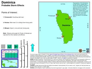
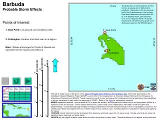
Comprehensive topographical and wind/wave surge data for the Leeward Islands, including wind speeds, wave heights, and storm categories.

E N D
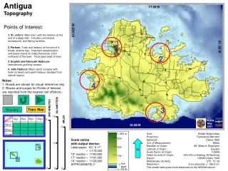
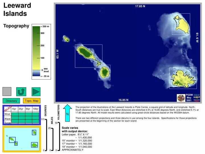
Leeward Islands Topography > 250 m 17.85 N 300 200 100 61. 6 W 0 sea level DEGREES Ross Wagenseil for PGDM April 2001 < - 35 m 63.1 W MILES 25 KILOMETERS 0.5 50 0 PGDM May 2001 10yr 25yr 50yr 100yr SELECT 16.85 N Wind Wave Surge 0 0 Topo. Map Directory N The projection of the illustrations of the Leeward Islands is Plate Carrée, a square grid of latitude and longitude. North-South distances are true to scale. East-West distances are stretched 4.5% at 16.85 degrees North, and stretched 5.1% at 17.85 degrees North. All model results were calculated using great-circle distances based on the WGS84 datum. There are two different projections and three datums in use among the four islands. Specifications for those projections are presented at the beginning of the section for each island. Scale varies with output device: Letter paper, 8½” X 11” ~ 1/1,430,000 15” monitor ~ 1/1,320,000 17” monitor ~ 1/1,160,000 19” monitor ~ 1/1,040,000 APPROXIMATELY
17.85 N 61. 6 W DEGREES Ross Wagenseil for PGDM April 2001 63.1 W MILES 25 KILOMETERS 0.5 50 0 PGDM May 2001 10yr 25yr 50yr 100yr SELECT 16.85 N Wind Wave Surge 0 0 Wind Speeds 0 1 2 3 4 5 Storm Category knots 25 50 75 100 125 mph 25 50 75 100 150 125 kph 50 100 150 200 250 Min m/s 20 60 10 30 40 50 70 Max Winds Probability 10% / year, 10-Year Return Time Leeward Islands Directory Topo. Map N
17.85 N 61. 6 W DEGREES Ross Wagenseil for PGDM April 2001 63.1 W MILES 25 KILOMETERS 0.5 50 0 PGDM May 2001 10yr 25yr 50yr 100yr SELECT 16.85 N Wind WaveHeights Wave Surge 0 0 6 4 1 3 5 2 7 Meters 5 10 25 Feet 20 15 Min Max Waves Probability 10% / year, 10-Year Return Time Leeward Islands Directory Topo. Map N
17.85 N 61. 6 W DEGREES Ross Wagenseil for PGDM April 2001 63.1 W MILES 25 KILOMETERS 0.5 50 0 PGDM May 2001 10yr 25yr 50yr 100yr SELECT 16.85 N Wind Wave Surge Heights Surge 0 0 1 2 3 4 6 5 Meters 20 15 10 5 Feet Min Max Surges Probability 10% / year, 10-Year Return Time Leeward Islands Directory Topo. Map N
17.85 N 61. 6 W DEGREES Ross Wagenseil for PGDM April 2001 63.1 W MILES 25 KILOMETERS 0.5 50 0 PGDM May 2001 10yr 25yr 50yr 100yr SELECT 16.85 N Wind Wave Surge 0 0 Wind Speeds 0 1 2 3 4 5 Storm Category knots 25 50 75 100 125 mph 25 50 75 100 150 125 kph 50 100 150 200 250 Min m/s 20 60 10 30 40 50 70 Max Winds Probability 4% / year, 25-Year Return Time Leeward Islands Directory Topo. Map N
17.85 N 61. 6 W DEGREES Ross Wagenseil for PGDM April 2001 63.1 W MILES 25 KILOMETERS 0.5 50 0 PGDM May 2001 10yr 25yr 50yr 100yr SELECT 16.85 N Wind WaveHeights Wave Surge 0 0 6 4 1 3 5 2 7 Meters 5 10 25 Feet 20 15 Min Max Waves Probability 4% / year, 25-Year Return Time Leeward Islands Directory Topo. Map N
17.85 N 61. 6 W DEGREES Ross Wagenseil for PGDM April 2001 63.1 W MILES 25 KILOMETERS 0.5 50 0 PGDM May 2001 10yr 25yr 50yr 100yr SELECT 16.85 N Wind Wave Surge Heights Surge 0 0 1 2 3 4 6 5 Meters 20 15 10 5 Feet Min Max Surges Probability 4% / year, 25-Year Return Time Leeward Islands Directory Topo. Map N
17.85 N 61. 6 W DEGREES Ross Wagenseil for PGDM April 2001 63.1 W MILES 25 KILOMETERS 0.5 50 0 PGDM May 2001 10yr 25yr 50yr 100yr SELECT 16.85 N Wind Wave Surge 0 0 Wind Speeds 0 1 2 3 4 5 Storm Category knots 25 50 75 100 125 mph 25 50 75 100 150 125 kph 50 100 150 200 250 Min m/s 20 60 10 30 40 50 70 Max Winds Probability 2% / year, 50-Year Return Time Leeward Islands Directory Topo. Map N
17.85 N 61. 6 W DEGREES Ross Wagenseil for PGDM April 2001 63.1 W MILES 25 KILOMETERS 0.5 50 0 PGDM May 2001 10yr 25yr 50yr 100yr SELECT 16.85 N Wind WaveHeights Wave Surge 0 0 6 4 1 3 5 2 7 Meters 5 10 25 Feet 20 15 Min Max Waves Probability 2% / year, 50-Year Return Time Leeward Islands Directory Topo. Map N
17.85 N 61. 6 W DEGREES Ross Wagenseil for PGDM April 2001 63.1 W MILES 25 KILOMETERS 0.5 50 0 PGDM May 2001 10yr 25yr 50yr 100yr SELECT 16.85 N Wind Wave Surge Heights Surge 0 0 1 2 3 4 6 5 Meters 20 15 10 5 Feet Min Max Surges Probability 2% / year, 50-Year Return Time Leeward Islands Directory Topo. Map N
17.85 N 61. 6 W DEGREES Ross Wagenseil for PGDM April 2001 63.1 W MILES 25 KILOMETERS 0.5 50 0 PGDM May 2001 10yr 25yr 50yr 100yr SELECT 16.85 N Wind Wave Surge 0 0 Wind Speeds 0 1 2 3 4 5 Storm Category knots 25 50 75 100 125 mph 25 50 75 100 150 125 kph 50 100 150 200 250 Min m/s 20 60 10 30 40 50 70 Max Winds Probability 1% / year, 100-Year Return Time Leeward Islands Directory Topo. Map N
17.85 N 61. 6 W DEGREES Ross Wagenseil for PGDM April 2001 63.1 W MILES 25 KILOMETERS 0.5 50 0 PGDM May 2001 10yr 25yr 50yr 100yr SELECT 16.85 N Wind WaveHeights Wave Surge 0 0 6 4 1 3 5 2 7 Meters 5 10 25 Feet 20 15 8 Min Max Waves Probability 1% / year, 100-Year Return Time Leeward Islands Directory Topo. Map N
17.85 N 61. 6 W DEGREES Ross Wagenseil for PGDM April 2001 63.1 W MILES 25 KILOMETERS 0.5 50 0 PGDM May 2001 10yr 25yr 50yr 100yr SELECT 16.85 N Wind Wave Surge Heights Surge 0 0 1 2 3 4 6 5 Meters 20 15 10 5 Feet Min Max Surges Probability 1% / year, 100-Year Return Time Leeward Islands Directory Topo. Map N