Download
1 / 46
460 likes | 468 Vues
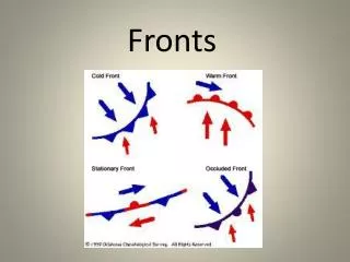
Doppler radar? God only knows what it means! We will all know after we take the MSC Radar Course though. For God's sake, we had to wait 25 years for Doppler… I pray it won't be that long to get Dual Polarized!. Cold Fronts - Outline. Cold Front Basics Conceptual Models

E N D
Doppler radar? God only knows what it means! We will all know after we take the MSC Radar Course though.
For God's sake, we had to wait 25 years for Doppler… I pray it won't be that long to get Dual Polarized!
Cold Fronts - Outline • Cold Front Basics • Conceptual Models • Conventional Radar Signatures • Doppler Signatures • Conveyor Belt Conceptual Model (CBCM) • Summary You are wondering… “How Can I fill an hour with radar cold fronts?” phil
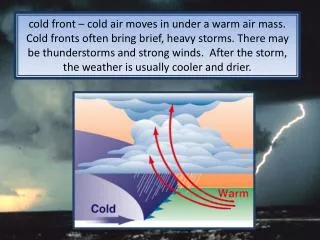
The Classic Cold Front S. Petterssen's 1956 text: Weather Analysis and Forecasting, Vol. 1, Motion and Motion Systems, pp. 189 ...let the term FRONTAL SURFACE denote a sloping surface or zone of transition separating two air masses of different density. Similarly, the term FRONT will denote the intersection of the frontal surface with a chart. In these definitions the emphasis is upon the SLOPING arrangement of a DENSITY contrast. The mixing zone is behind the surface front and under the frontal surface
The Classic Cold Front – Conventional Radar Typically heavy precipitation near surface front Precipitation typically convective Other things to consider include: Precipitation Type Bright banding Attenuation Anomalous Propagation Beam Blocking Radar Dome Wetting Non-meteorological targets etc Sometimes precipitation after cold front Sometimes precipitation before and after cold front Sometimes precipitation before and after cold front Sometimes precipitation before cold front From Conventional Data do we really know where the cold front is? Take Home Message (THM): Conventional radar for precipitation distribution, character, phase & more
The Classic Cold Front – Doppler Radar Strong Cold Advection – beam above ANA front Weak Warm Advection – beam in mixing zone or above frontal surface to here Strong Cold Advection – beam likely under frontal surface to here Strong Cold Advection in PBL behind Cold front – No frictional Ekmann Spiral Slope of 1/50 cold front = 1.1o Winds back above surface Slope of 1/200 warm front = 0.3o Vertical Discontinuity (Cold Advection) at 250 m SE of radar Vertical Discontinuity (Cold)at 700 m NW of radar … Frontal Slope … ??????? SE of radar SWLY winds veer slightly with height… in Warm Sector NW of radar SWLY winds veer slightlyand then back strongly with height… NW of radar a 1.5 degree beam follows a slope of about 1:40 meaning… Take Home Message (THM): Doppler radar for winds, VWS, front location, slope, advections, stability… do you know where your beam is ?.. complicated the 1.5 degree beam might switch above or below the cold frontal surface .
The Classic Cold Front Conventional and Doppler Radar Surface front ahead of elevated front They are very different … They both have valuable information… Take Home Message (THM): Conventional and Doppler radar allow analysis and diagnosis of real WX
C Warm Cold The Classic Cold Front Circulation and deformation occur at every level in the atmosphere. The surface cold front is JUST One. Think of the cold frontal surface and the deformation zone/skin as a surface separating air masses.
Cold Radar Viewing Radar Interpretation of the Cold Frontal Discontinuity is Complex 3D of Radar Measurement and 3D of the Cold Frontal Surface
Kata Jet axis crosses frontal cloud band Zero vorticity line crosses front - higher cloud poleward & lower clouds equatorward Clouds and precipitation: ahead of cold front Associated with warm advection – or weakening cold advection Ana Jet axis & dry intrusion parallel the frontal cloud band to form a sharp rear cloud edge Zero vorticity line parallels/near sharp back cloud edge Clouds and precipitation: along and behind the cold front Associated with cold advection – mdt to strong Anabatic and KatabaticCold Fronts Red for “Stop” Green for “GO” Frontogenesis Active Knot active Frontolysis Ascent Descent JET
Active or AnabaticCold front Active Ascent Frontal Speed Winds above front slower Winds back with height above the cold front to the left of the COL Backing winds mean unstable - ActiveGreen for “Go”
Inactive or KatabaticCold Front Knot active Descent Frontal Speed Winds above front faster Winds veer with height above the cold front to the right of the COL Veeringwinds meanstable - Knot activeRed for “Stop”
Warm Conveyor Belt Warm Conveyor Belt Anabatic and KatabaticCold Fronts Knot active Active WXBefore WX After From my Buddies at ZAMG
Warm Conveyor Belt Warm Conveyor Belt Warm Conveyor Belt SplitCold Front Conceptual Model • WCB (Warm Conveyor Belt) • Jet streak and positive vorticity advection (PVA) at a large acute angle • Dry above the low level cloud band and a strong gradient between the two cloud bands at different heights. • Left of jet fronts tend to be ANA in character. • Right of jet fronts tend to be KATA in character Jet Streak
SplitFront Weather Cellular on radar Ana Upper Front Kata Upper Front Take Home Message (THM): With split front most WX with upper cold front – still apply ANA, KATA ideas.
C Warm Warm Warm Cold Transitional Cold Fronts Applying the Deformation Zone Conceptual Model Ana Green for “GO” Ascent Descent cyclonic anticyclonic Descent anticyclonic Ascent Kata Redfor “STOP” cyclonic
C Transitional Cold Fronts Ana Related to weather… Ascent Descent Descent Kata Ascent Take Home Message (THM): Deformation Zone Conceptual Model consistent with Ana and Kata CM’s
Transitional Cold Fronts Applying the Deformation Zone Conceptual Model Ana Kata to Ana and KataCold Fronts CM’s. Highly Idealized but… a useful Conceptual Model that can assist…
Warm Conveyor Belt Warm Conveyor Belt SplitFront and the Upper Deformation Zone Ana Ascent Descent Ana Kata Apply to both surface and uppercold fronts Kata
Conventional Radar • Anabatic - Ana Front - Active - WX After Front • Katabatic - Kata Front - Knot Active - WX Before Front • Placement of clouds and weather relative to cold front What kind of cold front?
Doppler Radar • Anabatic - Ana Front - Active - WX After Front • Katabatic - Kata Front - Knot Active - WX Before Front • Placement of clouds and weather relative to cold front • Wind direction – depends on viewing perspective • Usually sharp change in wind direction • Usually sharp change in radial wind component • Discontinuity on Doppler • Discontinuity along a range ring or radial ? • Discontinuity = line Not along a range ring
Doppler – Cold Front Approaching Radar • Assuming there is widespread precipitation! What Doppler Sectors? What Doppler Colours? Where? Anabatic Precipitation Distribution? Katabatic Precipitation Distribution? Ana - main zone of cloudiness and precipitation after the surface front. Kata - main zones of cloudiness and precipitation before the surface front.
Doppler – Cold Front Past Radar • Assuming there is widespread precipitation! What Doppler Sectors? What Doppler Colours? Where? Katabatic Precipitation Distribution? Anabatic Precipitation Distribution? Kata - main zones of cloudiness and precipitation before the surface front. Ana - main zone of cloudiness and precipitation after the surface front.
Doppler – Cold Front Approaching Radar Is it simple? Yes No Depends where the Doppler Radar is… Relative to the pattern…
Doppler – Cold Front Past Radar Is it simple? Yes No Depends where the Doppler Radar is… Relative to the pattern…
AnabaticorKatabaticCold Front Ontario Example ? Overshooting Veering Isodop = Warm Advection FuzzyIsodop disconnected at Front Disconnnect not along ring = spatial (not vertical) Notice: the west of cold front Isodop backs with respect to the radar & Isodop itself veers (slightly) with height… Cold Advection Stabilization
3 hours later AnabaticorKatabaticCold Front Ontario Example 1.4 km Above Cold Frontal Surface? 1.6 km Stay flexible Ongoing Analysis and Diagnosis is Vital… 0.5o radar elevation at 100 km radial from the radar has beam at 1.4 km Height of 1:50 cold front 80 km WNW of surface front is 1.6 km… The Radar is probably sampling the warm air above the cold frontal surface which must have a shallower slope closer to 1:60
AnabaticorKatabaticCold Front Nova Scotia Example 140 km Spatial Discontinuity does NOT FOLLOW Range rings Front climbs 3 km in 140 km giving frontal slope of 1:45. ANA steeper than average. Backing above ANA front also consistent. Nil Isodop Veering IsodopBacking– ColdAdvection IsodopBacking – Cold Advection IsodopVeering – Warm Advection Where is the front intercepted aloft? 1.5 km Or is front higher? Backing at 3.0km characteristic of Anabatic Front
Nova Scotia Example Lesson here – Doppler behind a cold front is tricky! Above Ana Front Scale Exaggerated In Mixing Zone In Frontal Cold Advection 1.5 deg On Average this cold front not as steep as 1.5 o Except at the leading edge. 1.5 Degree Elevation Angle = 1:38 slope Estimated frontal slope = 1:45 (not quite as steep) ANA steeper than average (1:50) Backing above ANA front also consistent.
Another Cold front Anabaticor KatabaticCold Front WSO Southwestern Ontario 0120Z Dec 23, 2006 CAPPI 1.5 km Rain rate Cut a cross-section Applying Conceptual Models to patterns is fundamental to operational meteorology.
The same Cold front Katabatic You can almost see the subsidence… Vertical Cross-Section WSO Southwest Ontario 0120Z Dec 23, 2006 Rain rate GEM temps contoured; T0 orange; Tw0, Tw2, Tw5in blues Descent SW GEM cold front NE
The same Cold front Cold sector Isodop almost backs… counter clockwise Warm sector Isodopveers… clockwise WSO Southwestern Ontario 0120Z Dec 23, 2006 -0.09° Radial Velocity Cold Advection over Warm Advection ? Destabilization – Isodop backs with range/height ? Is it real? Yes, it is real – but SO weak & where relative to frontal surface?
The same Cold front 2 hours later Not much of aCOLD front Cold sector Isodop veers… clockwise ??? WSO Southwestern Ontario 0320Z Dec 23, 2006 -0.09° Radial Velocity But wait… this makes no sense… -0.09o = near surface= frictional Ekmann Spiral
Cold front WSO Southwestern Ontario 0320Z Dec 23, 2006 VAD The lesson here – look at all data for evidence & a solution Isodop and Winds back with height As they should behind a cold front!
The same Cold front 2 hours later Anabaticor KatabaticCold Front 2 hours later… still Katabatic WSO Southwestern Ontario 0320Z Dec 23, 2006 CAPPI 1.5 km Rain rate Most pcpn is out ahead of cold front
The Conveyor Belt Conceptual Model L C R Cold Front Conceptual Models With a Radar Emphasis R = Right of the Col C = Centered on the Col L = Left of the Col End
The Conveyor Belt Conceptual Model Think in 3-D End
Radar Signatures Relative to the Conveyor Belts NLY Flows Sinking Isentropically SLY Flows RisingIsentropically Think in 3-D End
C C C C C C DCB CCB DCB DCB Vertical Deformation Zone Distribution and the CBCMSummary Left of the Col • DCB rises isentropically as it curls cyclonically northward • Located in the dry slot of the comma head • Winds back with height above the cold frontal surface • The cold frontal slope is steeperthan the average 1:50 • Cold front is likely Anabatic Left of COL DCB Back End
C C C C C C DCB CCB DCB DCB Vertical Deformation Zone Distribution and the CBMSummary Right of the Col • DCB sinks isentropically as it curls anticyclonically southward • Located along the equatorward tip of the comma tail • Winds veer with height above the cold frontal surface • The cold frontal slope is more shallow than the average 1:50 • Cold front is likely Katabatic Right of COL DCB Veer End
DCB WCB Behind the Cold Front Conceptual Models Left of the Col looking across the flow B A WCB oriented for more frontal lift Deep Instability And moisture likely Mixing Zone CCB More frontal Lift with backing Surface Cold Front B A Cold air in Cold Conveyor Belt(CCB) deep & moist. Precipitation will be extensive for acceptable radar depiction of the features Warm Conveyor Belt (WCB) very deep, warm, moist and rising isentropically CCB approximately horizontal or rising slightly and moving southeastward CCBbacks with strong cold advection WCB just ahead of cold front backs with significant VWS Frontal slope is steeper than the typical 1:50 Significant backing above the frontal zone – anabaticcold front End
DCB WCB Behind the Cold Front Conceptual Models Right of the Col looking across the flow. A WCB oriented for less frontal lift B Mixing Zone Less frontal Lift with veering Surface Cold Front CCB Chance of deep instability B A Cold air in Cold Conveyor Belt(CCB) shallow & dry. Precipitation will be lacking for radar depiction of the features Warm Conveyor Belt (WCB) is shallow, warm, moderately moist and rising isentropically CCB sinks isentropically southwestward CCBveers with height consistent with weakening cold advection ~ warm advection WCB just ahead of cold front also typically veers with height Frontal slope is more shallow than the typical 1:50 Veering winds above the frontal zone indicative of katabaticcold front End
C o DCB to the Left of the Col - Doppler The Cold Left Wing Climb Conceptual Model • DCB in dry slot is typically ascending and backing • Steeper frontal slope will be evident. • Within the CCB – Cold Advection: • Cold advection backing probably overpowers the Ekman spiral veering. Beaked eagle. Mixing layer Cold frontal surface Dry CB • Within the DCB: • West of radar backing, cold advection, Anabaticcold front • East of radar nil VWS or possibly weaker backing Right Wing Left Wing End
The Cold Left Wing Climb CM Anabatic ! This cold front is oriented NNE-SSW. End
Cold Fronts - Outline • Cold Front Basics • Conceptual Models • Conventional Radar Signatures • Doppler Signatures • Conveyor Belt Conceptual Model (CBCM) • Summary Keep Looking UP! Thank you for your attention! Remote sensing is your Friend! Take Home Message (THM): Radar is useful to analyze and diagnosis cold fronts … Doppler is tricky!
Radar Analysis and Diagnosis of Cold Fronts One Final Take Home Message (THM): Expect any cyclonic, backing flow to be anabatic. Expect any anticyclonic, veering flow to be katabatic. Southerly flows typicallyrise isentropically. Northerly flows typicallysink isentropically.