Download
1 / 32
460 likes | 793 Vues
Land Management and Spatial Enabled Government Prof. Stig Enemark President Aalborg University, Denmark. MAP MIDDLE EAST 2008 DUBAI, UAE, 8-10 APRIL 2008. Outline of Presentation. Underpinning Land Management Rights – Restrictions – Responsibilities Spatially Enabled Government

E N D
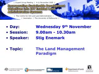
Land Management and Spatial Enabled Government Prof. Stig Enemark President Aalborg University, Denmark MAP MIDDLE EAST 2008 DUBAI, UAE, 8-10 APRIL 2008
Outline of Presentation • Underpinning Land Management • Rights – Restrictions – Responsibilities • Spatially Enabled Government • The Role of FIG • Facing the Millennium Development Goals • “Building the Capacity”
Understanding the Land Management Paradigm Land Management includes all activities associated with the management of land and natural resources that are required to fulfill political objectives and achieve sustainable development.
Lack of an integrated approach • In many countries there is a tendency to separate • land tenure rights from land use rights • Planning and land use control is not linked with • land values and the operation of the land market. • This may be compounded by poor management • procedures that fail to deliver required services. • This reveals a much deeper problem: the failure • to treat land and its resources as a coherent whole. • Many countries around the world - also in Europe – • are facing problems in this regard and with regard • to informal urban development.
Land Administration Systems (LAS) LAS provide the infrastructure for implementation of land polices and land management strategies in support of sustainable development. Land Tenure: the allocation and security of rights in lands; the legal surveys of boundaries; the transfer of property through sale or lease; and the management; adjudication of disputes regarding rights and boundaries. Land Value: the assessment of the value of land and properties; the gathering of revenues through taxation; and the management and adjudication of land valuation and taxation disputes. Land-Use: the control of land-use through adoption of planning policies and land-use regulations at various levels; the enforcement of land-use regulations; and the management and adjudication of land-use conflicts. Land Development:the building of new infrastructure; the implementation of construction planning; and the change of land-use through planning permission and granting of permits.
Interests in land Land administration systems are the basis for conceptualising rights, restrictions and responsibilities related to people, policies and places. Rights: Tenure positions Responsibilities: Cultural attitudes Restrictions: Land use options
The RRR´s • Property Rights • - Are concerned with ownership and tenure • - Are normally available in the Land Registry • Property Restrictions • - Are concerned with controlling use and activities on land • - Are normally available through planning documents • or general land use provisions • Property Responsibilities • - Relate to a more social, ethical commitment or attitude to • environmental sustainability and good husbandry. • - The human kind to land relationship is dynamic.
The increasing role of property rights • ”Civilised living in market economies • is not simply due to greater prosperity • but to the order that formalised • property rights bring” • Hernando de Soto - 1993
Land Registration Systems around the World Deeds System (French): A register of owners; the transaction is recorded – not the title. Title System (German, English, Torrens): A register of properties; the title is recorded and guarantied.
What is a good property system ? • People in general can participate in the land market; widespread ownership; everybody can make transactions and have access to registration • The infrastructure supporting transactions must be simple, fast, cheap, reliable, and free of corruption. • The system provides safety for housing and business, and for capital formation • Only 25-30 countries in the world • apply to these criteria.
A worldwide Comparison of Cadastral Systems www.cadstraltemplate.org
Land Use Restrictions • Rights to land also include the rights of use, however: • - The right of use is limited through public land use planning regulations • and restrictions, sectoral land use provisions, and private land use • regulations • - Many land use rights are in fact restrictions that control the future • use of land. The number and kind of land use restrictions is huge. • - Land Use restrictions will normally not appear in the Land Registry, • but may be available through planning documents and general • land use provisions
Property Restrictions - two conflicting approaches • The free market approach (current debate in the US) • - Land owners should be obligated to no one and should have complete • domain over their land. • - The role of government to take over, restrict, or even regulate its use • should be non-existent or highly limited. • - Planning restrictions should only be imposed after compensation • for lost land development opportunities • The central planning approach (European perspective) • - The role of democratic government include planning and regulating • land systematically for public good purposes. • - A move from every kind of land use being allowed unless it was • forbidden to every change of land use is forbidden unless it is permitted • and consistent with adopted planning regulations and restrictions.
Responsibilities: A cultural map of the world Uncertainty avoidance: The preference of structured situations over unstructured or flexible ones Power distance: The degree of inequality among people accepted by the population Geert Hofstede (2001). Professor of Organizational Anthropology and International Management )1985-93), Maastricht University, the Netherlands
Good Governance is essential • Sustainability: balancing social, economic and environmental needs while being responsive to the present and future needs of society. • Subsidiarity:allocation of authority at the closest appropriate level consistent with efficient and cost-effective services • Equity:Women and men must participate as equals in all decision making, priority setting, and resource allocation processes • Efficiency: Public services and local economic development must be financially sound and cost-effective. • Transparency and Accountablity:Decisions taken and their enforcement follows rules and regulations. Information must be freely available and directly accessible. • Civic Engagementand Citizenship:Citizens must be empowered to participate effectively in decision-making processes. • Security:All stakeholders must strive for prevention of crime and disasters. Security also implies freedom from persecution, forced evictions and provision of land tenure security. Adapted from UN-Habitat 2002 • All kind of government includes a spatial component
A Land Management Vision Facilitating Sustainable Development Economic, Social, Environmental, Governance Enhancing Quality of Life Spatially Enabled Land Administration Land Tenure, Land Value, Land Use, Land Development Land Policy Framework Services to Business & Citizens Country Context Institutional Arrangements Capacity Building Education & Research
Spatially Enabled Government Spatially enabled government is achieved when governments use place as the key means of organising their activities in addition to information, and when location and spatial information are available to citizens and businesses to encourage creativity. Centre for Spatial Data Infrastructure and Land Administration Department of Geomatics, University of Melbourne, 2006. emergency response, taxation assessment, environmental monitoring and conservation, economic planning and assessment, social services planning, infrastructure planning, etc, etc
Spatially Enabled Government • A spatially enabled government organises its business and processes around “place” based technologies, as distinct from using maps, visuals, and web-enablement. • Identification of “the place” in ways that are understandable by non-technical people (Google Earth) • Capacity of businesses and citizens to manipulate the information should be organised through the use of service oriented IT- architecture. • The technical core of Spatially Enabling Government is thespatially enabled cadastre.
The role of FIG What is the role of in this regard?
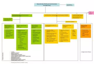
The International Federation of Surveyors Organizational Structure Annual General Assembly 97 member associations (90 countries) FIG Office Director 2 assistants Council President and 4 Vice-Presidents ACCO Advisory Committee of Commission Officers Com1 Practice Com3 Spat.Inf.Man Com5 Posit.&Map Com7 Cad&LandMan. Com9 Valuation Com2 Education Com4 Hydrography Com6 Eng.Surveys Com8 Spat.Plan.&Dev. Com10 Quantity Surv.. Chairman, vice-chairs, national delegates, work plan, working groups, seminars etc www.FIG.net
97 FIG Member Associations from 90 Countries 20 affiliates, 15 corresponding, 85 academic, 34 corporate members (Jan 2008) Full member Affiliate Correspondent
The Global Agenda Is strongly committed to the MDGs and the UN-Habitat agenda on the GLTN
The UN Millennium Development Goals Goal 1: Eradicate extreme poverty and hunger Goal 2: Achieve universal primary education Goal 3: Promote gender equality and empower women Goal 4: Reduce child mortality Goal 5: Improve maternal health Goal 6: Combat HIV/AIDS, malaria and other diseases Goal 7: Ensure environmental sustainability Goal 8: Develop a Global Partnership for Development The framework includes 18 targets and 48 indicators enabling the ongoing monitoring of annual progress
It is all about: People,human rights, engagement and dignityPolitics,land policies and good governancePlaces,shelter, land rights, and natural resourcesPower and
Cooperation Agreement with UN-Habitat Traditional cadastral systems do not provide for security of tenure in informal settlements. A more flexible system is needed for identifying the various kind of social tenure existing in informal settlements. Such systems must be based on a global standard and must manageable by the local community Itself: The Social Tenure Domain Model.
Cooperation Agreement with the World Bank • Mutual representation at conferences, forums and meetings • Mutual representation in collaborative projects • Joint publications • Joint promotion • Organizing a joint WB/FIG high profile conference March 2009 at the WB headquarters in Washington DC entitled “Land Administration in Support of the MDG´s”
The role of FIG “Building the capacity”
The role of the surveying profession The MDGs is a powerful concept towards development, security and human rights for all. The surveying profession plays is key role by providing: • Geographic information in terms of mapping and databases on the natural and built environment • Secure tenure systems • Systems for land valuation, land use management and land development • Systems for transparency and good governance
The Role of FIG • Professional Development • - Global forum for professional discussions and interactions • - Conferences, symposia, commission working groups, ….. • Institutional Development • - Institutional support for educational and professional • development at national and international level • Global Development • - Cooperation with international NGO´s such as • the UN agencies, World Bank, and sister organisations • - Joint activities and common policy-making to • reduce poverty and enforce sustainable development
From Cadastre to Holistic and Pro Poor Land Management • Holding of rights to lands • Economic aspects of land • Control of land use and land development Administering the people to land relationship through • Land Policy • Land Management • Good Governance and • Building the capacity to deal with this
Thank you for your attention