Download
1 / 1
10 likes | 88 Vues
Possibility of stratospheric hydration by overshooting analyzed with space-borne sensors Suginori Iwasaki (National Defense Academy, Japan)

E N D
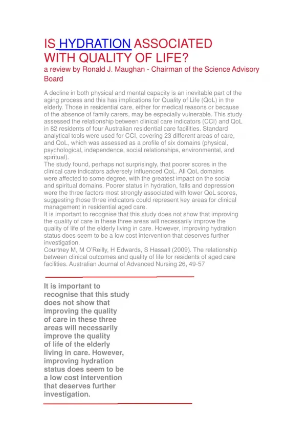
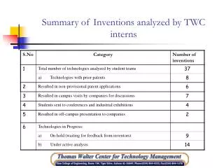
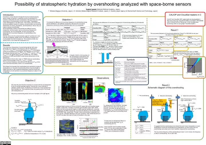
Possibility of stratospheric hydration by overshooting analyzed with space-borne sensors Suginori Iwasaki (National Defense Academy, Japan) T. Shibata (Nagoya University, Japan.), H. Ishimoto (Meteorological Research Institute, Japan), H. Kubota (Japan Agency for Marine-Earth Science and Technology, Japan) CALIOP and CloudSat readers in C Introduction Overshoot, a cloud intrusion through the level of neutral buoyancy above a deep convection, is believed as one of mechanisms to hydrate or dehydrate the lower stratosphere. Because there are a few observations of overshooting, its role in the Upper Troposphere / Lower Stratosphere is not well known. The A-train is one of the most promising satellite missions to measure vertical profiles and horizontal distributions of clouds, precipitation, and temperature; hence, they can clearly measure overshooting. Since thresholds to detect overshooting are different among researches, and the results, such as occurrence frequency of overshooting, are not comparable, we first summarize the dependence of occurrence frequency of overshooting on the thresholds. We then show one of counter-examples against "overshot air is very cold due to adiabatic updraft; hence, the density of overshot air is much greater than that of ambient air. The overshot air falls very quickly and it is not mixed with stratospheric air." Results The occurrence frequencies of overshooting defined with some thresholds are compared. The frequency with the threshold of "HtopCloudSat > H380KAIRS" is the lowest because H380KAIRS is the highest among the thresholds we considered. The difference of occurrence frequencies retrieved with H380KAIRS and H380KECMWF, and HTropoAIRS and HTropoECMWF are agreed within 3 times, respectively. The vertical resolutions of AIRS and ECMWF would cause retrieval error of the frequencies. The threshold of the14-GHz radar on TRMM retrieves overshooting whose cloud top height is from HTmin to HTropo or lower. The occurrence frequency retrieved with the difference of TBB is tens times more than the others; hence, it is overestimated. We showed one example that overshooting was warmed by mixing of stratospheric air. The half of overshooting whose cloud top height is higher than that of 380 K potential temperature would be mixed with stratospheric air and warmed. Its occurrence frequency is about 5 /min in 20S-20N. • Objective 1 CALIOP and CloudSat HDF readers in C are downloadable in http://www.nda.ac.jp/~iwasaki/CALIPSO_CLOUDSAT_PROGRAM/ which is linked from the "Resources" of the CloudSat data processing center (or just google "CloudSat reader") To estimate the difference of occurrence frequency of overshooting among several definitions in the different researches. Because the occurrence frequencies retrieved by these thresholds below are not comparable. We examine the difference of occurrence frequencies of overshooting defined by 8 thresholds as follows: Result 1 The occurrence frequency of overshooting defined by "Case X" in 20S-20N for one year: the ratio of "Case 1" to "Case X" # The occurrence frequency of Case 1 is about 10 overshooting / min in Tropical area (Iwasaki et al. 2010JGR). HtopTRMM denotes a height of an echo top measured with the 14-GHz radar of the tropical rainfall measuring mission (TRMM) and its noise level is about 15 dBZ. HtopCloudSat denotes the same as HtopTRMM but the 94-GHz radar of the CloudSat, and its noise level is about −27dBZ. H380KAIRSdenotes a height of 380 K potential temperature estimated with AIRS. Htop denotes a height of a cloud top of a deep convection. HtopCPR(15dBZ) denotes a height of an echo top of 15 dBZmeasured with 95-GHz radar on CloudSat (not TRMM). HTropo denotes a height of WMO tropopause. TBB(6.7μm) and TBB(11μm) are averaged with the nearest 9 pixels to remove striping noise. stratosphere Htop Htop 380K The threshold of the14-GHz radar on TRMM retrieves overshooting whose cloud top height is from HTmin to HTropo or lower height overshooting. A height of 380 K is the boundary of the climatological stratosphere and it is the best threshold to consider water budget between the stratosphere and the troposphere. no echo ground/sea Symbols overestimated Holton (1995, RG) Ratio = num. of Case X / num. of Case 1 Observations Objective 2 CALIOP CloudSat Suffixes AIRS and ECMWF denote values estimated with AIRS and ECMWF, respectively. Result 2 Schematic diagram of this overshooting We show the proof that the overshot air is mixed with that of stratosphere. # one of counter-examples against "overshot air is very cold due to adiabatic updraft; hence, the density of overshot air is much greater than that of ambient air. The overshot air falls very quickly and it is not mixed with stratospheric air." We pick up overshooting below and one of samples is the right figures. Example of overshooting No lidar return = The warmer radiation emitted from clouds of the lower height is not detected by MODIS. 1Pre-overshooting 2Matured overshooting 3Observed overshooting warm stratospheric air Note: Temperature at 18 km high is below 200 K TBBover Htopover > 19km? Temperature above 19 km high is warmer than 201 K. CloudSat cloud top HtopCloudSat or TBBover= 201K down Hover = 18km ToutECMWF,air TBB measured by use of MODIS. The black solid line denotes observation points of CALIOP, and white line denotes area of overshooting. TBB of overshooting becomes 3 − 4 K higher than that of surrounding cloud clusters. H380KECMWF mixing Latitude-Height sections of 532nm of CALIOP (upper left) and CloudSat (upper middle), respectively. Overlaps of CALIOP and CloudSat (upper right). White, yellow and red curves denote heights of 380K potential temperature, cold point temperature and MWO tropopause, and solid and dashed curves denotes AIRS and ECMWF data, respectively. Though it looks overshooting is separated from cirrus clouds, CloudSat detected it was one convection. Note: observed points of CALIOP are about 3km east of those of CloudSat in this case. mixing TBBCC = 193K Tad=178K 193K 193K Toutair< 200K 1Km CALIOP pseudo cloud base HCC = 16.9km 16.9km 16.9km Radiosondes X sonde 500km X Overshooting All data show air temperature below an overshot top are lower than TBB of overshooting (201 K). Since CALIOP could not detect signals below 15.5 km due to attenuation of light, TBB warmer than 200K emitted below 15.5km was not detected by MODIS. 500km X sonde sea sea sea Cloud top of overshooting ground/sea It suggests that the overshooting once entered the warm lower stratosphere or warm stratospheric air fell and overshooting and stratospheric air were mixed, then the overshooting came down and A-train satellites measured the overshooting. The occurrence frequency of this overshooting to Case 1 is 0.5; hence, the frequency is about 5 overshooting / min in 20S−20N. Cloud top of cloud cluster Conditions Kuching (1.48N, 110.3E), Malaysia Surabaja (7.37S, 112.8E), Indonesia HtopCloudSat > H380KECMWF (overshooting) TbaseCALIOP < TBBover (TBBover does not contain warmer TBB in troposphere) CALIOP cloud base A TBBover > ToutECMWF,air (ambient air temperature in TTL is cold)