Download
1 / 10
100 likes | 305 Vues
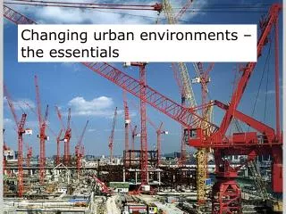
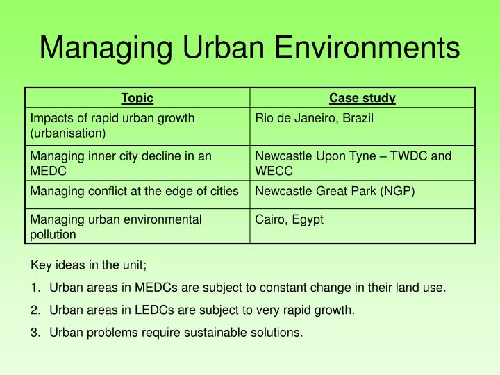
Managing Urban Environments. Key ideas in the unit; Urban areas in MEDCs are subject to constant change in their land use. Urban areas in LEDCs are subject to very rapid growth. Urban problems require sustainable solutions. Urbanisation – causes of growth of cities.

E N D
Managing Urban Environments • Key ideas in the unit; • Urban areas in MEDCs are subject to constant change in their land use. • Urban areas in LEDCs are subject to very rapid growth. • Urban problems require sustainable solutions.
Urbanisation – causes of growth of cities. • In most rich countries (MEDCs) city growth has slowed down and stopped. In LEDCs city growth continues. The increasing number of people living towns and cities is known as ubanisation, the main causes of urbanisation are natural increase and rural to urban migration (where people migrate from rural or countryside areas to urban areas). The table below summarises the causes of Urbanisation.
Impacts of rapid urban growth (urbanisation) – Rio de Janeiro Location Rio De Janiero is on the south-east coast of Brazil. It has a large port running through it and lies on the tropic of Capricorn. Rio De Janeiro Causes of problems. Rio De Janeiro is affected by urbanisation caused by Rural to Urban migration. This has resulted in the growth of many large favelas. Rochina is a favela which is home to over 100,000 people on one single hillside. Although the buildings have been improved, many are built by the people who live in them and lack some basic amenities such as toilets. There are no refuse collection facilities, schools are over crowded and drug crime is rife. Rio also suffers from urban pollution and traffic congestion. Rio cannot grow because of physical factors, to the North and West are mountain ranges, to the South and East lies water. This makes the traffic congestion problems and overcrowding in outlying shanty towns worse.
Impacts of rapid urban growth (urbanisation) – Rio de Janeiro Solutions to the problems in Rio • A new town has been built (see map) at Barra da Tihuca. This has shopping malls, busses, good schools, transport links and holds over 100,000 people. It is mainly for middle class residents of Rio who can afford to move. It is separated from Rio by a mountain range which had to be tunnelled to allow access to Rio. • Within the Favelas the government has assisted people in improving their homes. Breeze blocks and other materials (pipes for plumbing etc) were given as long as people updated their homes. • The government also moved a lot of people out of shanty towns and into low cost, basic housing estates with plumbing, electricity and transport links. The waiting list for these properties was huge. • Community policing has been encouraged with greater links between the police and the local communities and businesses, but drug gangs still pose a huge problem.
Managing inner city decline in an MEDC;Newcastle Upon Tyne – TWDC and WECC The problem. The riverside areas of Newcastle upon Tyne were responsible for the cities incredible growth and wealth during the industrial revolution. Heavy industries such as the Armstrong armaments works and ship building (e.g. Swan Hunters) employed tens of thousands of people from riverside communities in Newcastle such as Elswick and Scotswood. Overseas competition in these industries in the 1960s, 70s and 80s led to the decline and closure of these industries and the communities suffered as a result. The graph shows this decline in these riverside areas in comparison to the rest of Newcastle. The graph shows that the West End is a poorer area than Newcastle overall. There are a lot more people who live in a council property in the West End than Newcastle. This could be because of low monthly wages given to the people at the West end, this might be because of the people being under qualified in the area from lack of education. This also could be proven by the 30% of students still at school at the age of seventeen compared to the Newcastle area of 41%. This means that the area overall is under qualified and a lot poorer than Newcastle. Unemployment was an incredible 42%. Areas such as Scotswood and Benwell suffered economic, social and environmental (in the form of derelict buildings etc.) decline.
Managing inner city decline in an MEDC;Newcastle Upon Tyne – TWDC and WECC What did the government do and where? • They set up 2 groups do the work. • Each group was given an area to work in. • The Tyne and wear development corporation (TWDC) and west end city challenge (WECC). • The TWDC were given the area between quay side to the port. • The WECC were given the west end of Newcastle to work. Key words Regeneration – The complete demolition and rebuilding of an area. Renewal – The improvement of an urban area, using the building that are there and improving them.
Managing inner city decline in an MEDC;Newcastle Upon Tyne – TWDC and WECC
Managing conflict at the edge of cities - Newcastle Great Park (NGP) NGP is all about whether or not we should build in the greenbelt or regenerate inner city Brownfield sites. NGP is a major housing and commercial development that has been built on a GREENFEILD SITE within the GREENBELT. Its located north of Newcastle next to Gosforth. The government gave special permission for the development to go ahead. Newcastle Great Park lies three miles North-west of Newcastle City Centre and is one of the biggest mixed-use developments in the UK. Around 600-acres has been earmarked for business, residential and commercial development and a further 600-acres will be richly landscaped, open parkland. Where is NGP? The park is located close to the A1 London to Edinburgh trunk road and the A19, which gives good access to the North Sea Ferries, Sunderland and Teesside. The park also has good links with rail networks, Newcastle International Airport and the city centre. Key words Greenfield Site – a green area of land that is used for a housing, industry or recreational development. This land has not been built on before. Brownfield site – land that has been developed/built upon before but is now disused. This land is within the city, needs clearing and cleaning before being re-used. Greenbelt - an area of land that is protected by law from development, they surround cities and are designed to stop cities spreading into the countryside.
Managing conflict at the edge of cities - Newcastle Great Park (NGP)
CAIRO, EGYPT (MANAGING URBAN POLLUTION) Cairo is located to the east of the river Nile. This built up area has an airport to the north and to the east of the built up area is Eastern desert. This poses as a problem because the area now cannot expand to the west, due to the Nile and cannot expand to the east due to the desert region. The only way is north or south. Cairo’s main problem is overcrowding, and due to this overcrowding it means there is a great problem with pollution. Cairo is overcrowded for two reasons: people have moved from rural areas to the urban city in search of jobs and a better lifestyle the life expectancy has risen due to advances in medical care from 41yrs to 64 yrs Cairo's rapid population influx now means that there is over 30,000 people per square kilometre. This increase in population has lead to an increase in pollution: