Download
1 / 33
370 likes | 500 Vues
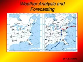
Meteorological Observations and Weather Forecasting. August 27 th , 2007. Meteorology. Not a laboratory science; the most important field observation science A Natural Science Synoptic meteorology- continuously recorded Asynoptic meteorology- recording dependent upon observing platform

E N D
Meteorological Observations and Weather Forecasting August 27th, 2007
Meteorology • Not a laboratory science; the most important field observation science • A Natural Science • Synoptic meteorology- continuously recorded • Asynoptic meteorology- recording dependent upon observing platform • Weather forecasting entails predicting how the present state of the atmosphere will change
Forecasting • Weather occurs in different layers of the atmosphere • Data recorded by land-based observation stations, ships, buoys, satellites, and other devices
Surface Weather Devices • Nephoscope – surface instrument for measuring direction and speed of cloud motion; passive remote sensing • Psychrometer – temperature • Hygrometer – humidity • Instrument shelters • Anemometers – measure wind speed and direction
Surface Weather Devices hygrometer psychrometer anemometer
Weather Stations • Surface observation points are supposed to be accurate for the vicinity (half way to next point); could be 37 miles away • Inaccuracies: • Instrument location • Calibration • Topography • Elevation
Radar • Radio Detection and Ranging • Used in meteorology since 1940s • Rain drops scatter radio waves very well • Cloud particles and ice doesn’t scatter well • Doppler Radar – senses frequency shifts in reflected radio waves • Gives information on velocity, location, and intensity of storm • Shows rotation • Can also detect insects, dust, and eddies
Lightning Detection • Causes disturbance in radio waves – sferics • All lightning strokes produce bursts, or pulses, of EM energy • Helps locate thunderstorms • Triangulation between stations • Lightning can occur with rainfall • Virga- precipitation that doesn’t reach the ground
Aerological Observations • Made in the upper atmosphere by aircraft and balloons • Radiosonde- reads pressure, temperature, and relative humidity; suspended under weather balloon; can travel to Tropopause • Ground truth satellite data • Dropsonde- dropped from plane; used over oceans
Dropsonde Radiosonde
LIDAR • Light Detection and Ranging • Used to measure speed, rotation, distance, and chemical composition of a remote target (cars, smoke plumes, clouds…)
Satellites • Primary uses • Observing clouds and atmospheric temperatures • Tropical cyclone development • Earth color and temperature • Movement of fronts
Satellites • GOES (Geostationary Operational Environmental Satellites) • Geosynchronous • 22,300 miles above equator • Can’t see above 60° latitude • Provides real-time photos – used to show cloud movement, dissipation, and development
Satellites • Polar-orbiting satellites • Follow meridians • Have advantage of photographing clouds directly beneath satellite • 530 mi above surface
Satellites • Operate in 4 spectral regions: • Visible- passive remote sensing; clouds reflect sunlight • Infrared- gives temperature of radiating bodies; information about cloud-top temperature
Satellites • Water Vapor – distinguish between dry and humid air masses • Microwaves – absorbed and emitted by rain drops • Visible through clouds • Rain appears warm and ocean surface appears cold • All objects emit radar – noise!
Satellites • Radiometers • Used by satellites to observe clouds day and night by detecting radiation from cloud tops • Thick clouds have higher reflectivity than thin clouds
National Weather Service • Watch – atmospheric conditions favor hazardous weather occurring for a specified region during a specified time period • Warning – hazardous weather either imminent or actually occurring with in forecast are • Advisories – for less hazardous conditions – wind, dust, fog, snow, sleet, and freezing rain
ASOS • Automated Surface Observing System • Operating mostly out of airports • Provides continuous information on wind, temperature, pressure, cloud-base height, and runway visibility
AWIPS • Advanced Weather Interactive Processing System • High speed data modeling system • Layers of maps and weather data, including satellites, Doppler radar, and ASOS • Daily predictions over grid with spacing as low as 1.2 miles between points
Soundings • Two-dimensional profile of temperature, dew-point, and winds • Good for short-range forecasts • Used in fog, air pollution, and wind advisories
Models • Computer enhancement – color assignment • Weather models better at predicting temperature and jet stream patterns than precipitation • Ensemble forecasting – run models multiple times with slightly different conditions; replication
What goes wrong in forecasts? • Models idealize atmospheric conditions; lots of assumptions • Errors at model boundaries • Grid spacing can be up to 37 miles apart • Water constantly changing state in atmosphere
Linear Interpolation • Estimation of weather at intermediate sites common • Use linear interpolation • Only works if terrain is completely flat
Other non-model forecasting methods • Persistence forecast • Trend or steady-state • Analogue • Statistical • Probability • Climatological
Folklore • Silver-side out • Midwestern oak leaves turn before a storm so that the underside faces into the wind • Increases in specific humidity cause leaves to become heavy and rotate out • Birds roost before a storm • So do planes