Download
1 / 22
230 likes | 782 Vues
Basic Guide to Calculating Atmospheric Dispersion Index (ADI, after Lavdas) . ADI is derived from mixing height, transport wind, and stability class. Many fields are already created in the Fire Weather Forecast process (ex. sfc winds and mixing height)

E N D
Basic Guide to Calculating Atmospheric Dispersion Index (ADI, after Lavdas)
ADI is derived from mixing height, transport wind, and stability class. • Many fields are already created in the Fire Weather Forecast process (ex. sfc winds and mixing height) • Stability class is derived from the Net Radiation Index (NRI)
Net Radiation Index (NRI) • NRI can be obtained using a set of cloud and ceiling rules. • The rules are divided into a day and night class. However, If the total opaque cloud cover is 10/10 and the ceiling height is <7,000 ft, use net radiation index equal to 0 (whether day or night).
Net Radiation Index (NRI) For nighttime : A. If total opaque cloud cover =< 4/10, use net radiation index equal to -2. B. If total opaque cloud cover >4/10, use net radiation index equal to -1.
Net Radiation Index (NRI) For daytime: A. Determine the insolation class number as a function of solar elevation angle according to the following table: Solar Elevation Angle (d) Insolation Class 60 < d 435 < d =< 60 315 < d =< 35 2 d =< 15 1 http://www.srrb.noaa.gov/highlights/sunrise/azel.html.
Net Radiation Index (NRI) If the total opaque cloud cover <= 5/10, the net radiation index is equal to the insolation class number. If the opaque cloud cover is >5/10, then follow the set of rules on the next slide.
Net Radiation Index (NRI) If the total opaque cloud cover > 5/10, modify the insolation class number by following these six steps: 1. Ceiling height less than 7,000 ft, subtract 2. 2. Ceiling height >= 7,000 ft but < 16,000 ft, subtract 1. 3. Total opaque cloud cover equal to 10/10, subtract 1. 4. If neither steps 1 and 2 nor 3 immediately above are applicable, assume the modified insolation class number is equal to the insolation class number. 5. If the modified insolation class number is less than 1, let it equal 1. 6. Set the net radiation index equal to the modified insolation class number.
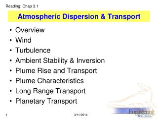
STABILITY CLASS as a function of Net radiation Index and Wind Speed
Deriving the ADI You will need the following information to derive the dispersion index (ADI) from the chart on the next slide 1. modified stability index 2. forecast mixing height 3. forecast transport wind
Basic Guide to Calculating Low Visibility Occurrence Risk Index (LVORI)after Lavdas and Achtemeier
Low Visibility Occurrence Risk Index (LVORI) • LVORI is calculated from the ADI and relative humidity, both of which are obtained from the forecast grids by the NWS LVORI software.
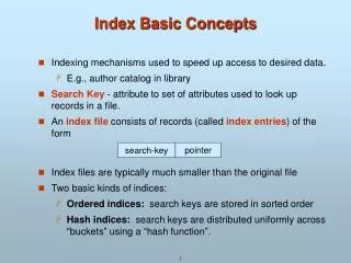
FWF: Fire Weather Planning Forecast TODAY TONIGHT SAT CLOUD COVER MCLDY MCLEAR MCLEAR CHANCE PRECIP (%) 50 0 0 PRECIP TYPE SLEET/RAIN NONE NONE MAX/MIN TEMP 45 29 53 MIN/MAX RH % 43 98 43 WND20FT2MIN/EARLY(MPH) SW 6 W 5 LGT/VAR WND20FT2MIN/LATE(MPH) W 8 G17 LGT/VAR LGT/VAR PRECIP DURATION 2 0 0 PRECIP AMOUNT 0.03 0.00 0.00 PRECIP BEGIN 6 AM PRECIP END 4 PM LAL 1 1 1 INVERSION(TEMP/TIME) 33/0900 2000 40/0900 HAINES INDEX 3 5 5 DSI 1 1 MIXING HGT(FT-AGL) 2700 2900 TRANSPORT WND (MPH) W 35 W 14 VENT RATE (MPH-FT) 94500 40600 ADI EARLY 42 49 24 ADI LATE 75 10 35 MAX LVORI EARLY 4 4 5 MAX LVORI LATE 1 6 1 REMARKS...ADI IS ATMOSPHERIC DISPERSION INDEX BY LAVDAS. LVORI IS LOW VISIBILITY OCCURRENCE RISK INDEX.