Download
1 / 10
100 likes | 170 Vues
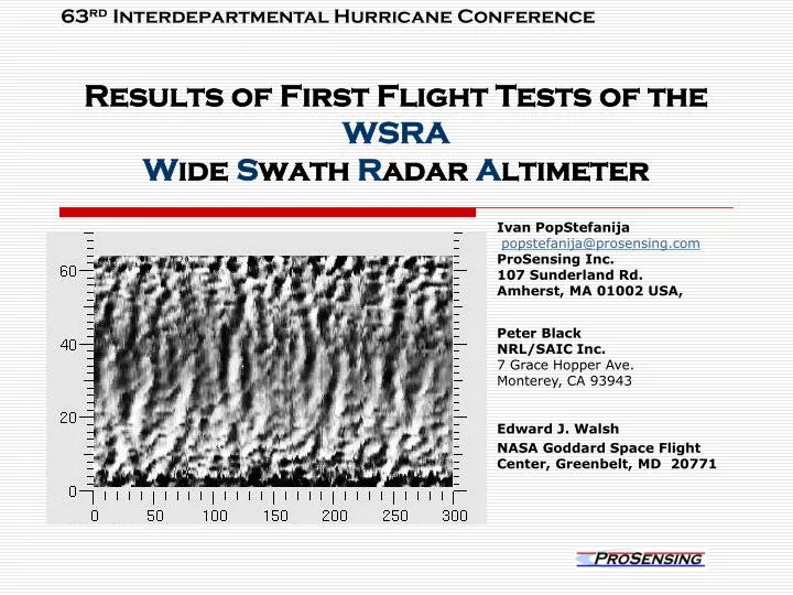
63 rd Interdepartmental Hurricane Conference. Results of First Flight Tests of the WSRA W ide S wath R adar A ltimeter. Ivan PopStefanija popstefanija@prosensing.com ProSensing Inc. 107 Sunderland Rd. Amherst, MA 01002 USA,. Peter Black NRL/SAIC Inc. 7 Grace Hopper Ave.

E N D
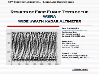
63rd Interdepartmental Hurricane Conference Results of First Flight Tests of the WSRAWide Swath Radar Altimeter Ivan PopStefanija popstefanija@prosensing.com ProSensing Inc. 107 Sunderland Rd. Amherst, MA 01002 USA, Peter Black NRL/SAIC Inc. 7 Grace Hopper Ave. Monterey, CA 93943 Edward J. Walsh NASA Goddard Space Flight Center, Greenbelt, MD 20771
Operational SRA • Why? • Mapping ocean wave height (surface topography) within the inner core of hurricanes • Measurement of directional ocean wave spectra • Real-time reporting of 12-foot seas radius • Improved forecasting of hurricane development • NASA’s SRA prototype has demonstrated instrument feasibility and data product utility operational SRA on multiple aircraft will provide routine data to enhance hurricane forecasting 28th Conference on Hurricanes and Tropical Meteorology
Who can benefit? • NOAA Tropical Prediction Center / National Hurricane Center • Fulfilling operational requirements for wave height and extent of 12 foot sea height radius • National Centers for Environmental Prediction • Development of comprehensive Hurricane Weather Research and Forecasting (HWRF) model SRA data used for modeling of the wave field and surface roughness
Prototype Scanning Radar Altimeter (SRA) was funded through NASA’s Advanced Application Flight Experiment (AAFE) program since 1973 SRA prototype has flown on NOAA’s WP-3D aircraft in every hurricane season since 1998 [retired 2005] NASA has developed a comprehensive SRA processing software: Transforms wave topography data into directional ocean wave spectra Extracts pertinent wave information Transmits wave information to the NHC in real-time Baseline Technology • SRA prototype specifications • 1 KW Klystron transmitter • 36 GHz operating frequency • Mechanically scanned offset reflector antenna (1.5º beam width )
Features and Benefits of Operational SRA 28th Conference on Hurricanes and Tropical Meteorology
Reduced Operating FrequencyAttenuation rate in rain drops by a factor of 5 Prototype 36 GHz SRA had frequent data loss due to rain attenuation. This problem is greatly reduced at 16 GHz. Comparison of minimum detectable ocean surface radar cross section for prototype 36 GHz SRA and 16.15 GHz SRA in heavy rain (25 mm/hour). 28th Conference on Hurricanes and Tropical Meteorology
Technology Description: • Digital beam forming antenna • Microstrip planar antenna array • Comprised of 62 sequentially sampled subarrays • Size: 30 in x 30 in x 2 in • Transmitter • 20 W solid-state transmitter • pulse compression processing • compression ratio of 1000:1 (at a flight altitude of 500 m) to over 6000:1 (at a flight altitude of 3 km) • effective peak power of the proposed system is 10-60 kW • Digital Receiver • SRA DAQ Hardware: Echotek ECDR-2-12210-PMC 210 digitizer embedded in a single board dual core Pentium processor 28th Conference on Hurricanes and Tropical Meteorology
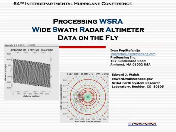
Data collection during the 2008 Hurricane Season • In the months of August and September of 2008 ProSensing operated and collected data with WSRA on six missions. • WSRA data was collected over a wide range of ocean surface conditions: from calm seas up to CAT 3 hurricanes.
WSRA data processing algorithm • Sequential transmission and collection of raw I&Q data for each of 62 antenna array elements. • Performing de-chirping FFT on each of the 62 I&Q vectors. • Averaging coherently subsequent frames of 62 vectors with the coherent integration time equivalent of the antenna traveling a distance of about 60 cm. • Multiplying the data with correction coefficients. • Performing the digital beam forming FFT at each range gate. • Calculating the magnitude (power) for the each beam return. Figure 15 shows the radar return for one beam at nadir. This creates a “frame”. • Averaging frames together to reduce signal fading. The averaging was set to generate 10 averaged frames per second. 28th Conference on Hurricanes and Tropical Meteorology
WSRA Data Quality • WSRA has expanded the operational range of the measurement conditions over the retired NASA prototype SRA • WSRA has obtained usable signal from a significantly higher altitudes (12,500 feet vs 5,000 feet). • WSRA signal was not significantly attenuated even under high rain rate conditions often found in hurricanes. • WSRA has demonstrated its capability to measure ocean wave spectra under a variety of wind conditions.