Download
1 / 27
270 likes | 420 Vues
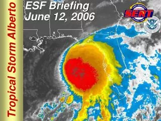
Tropical Storm Allison & its impact on Harris County. Binbin Chen. Introduction. Tropical Storm Allison formed 80 miles off the coast of Galveston, Texas on June 5, 2001 Over the next 5 days, Allison produced record-setting rainfall, flooding and damage in Harris County and city of Houston

E N D
Tropical Storm Allison & its impact on Harris County Binbin Chen
Introduction • Tropical Storm Allison formed 80 miles off the coast of Galveston, Texas on June 5, 2001 • Over the next 5 days, Allison produced record-setting rainfall, flooding and damage in Harris County and city of Houston • Because of the magnitude of flooding, Harris County Flood Control District and FEMA specially performed a project “Tropical Storm Allison Recovery Project (TSARP)”
Flooding after Allison 22 fatalities 95,000 damaged automobiles 73,000 damaged residences Over $5 billion in property damage
Project Purpose Perform an evaluation of the storm and its consequences in Harris County • Storm Track • Precipitation • Stream discharge • Flooding area Better understand water resource data and how to integrate different source data using ArcGIS
Data Sources • National Hurricane Center provides historical tropical ecyclone track GIS data at: http://maps.csc.noaa.gov/hurricanes/viewer.html • National Climate Data Center provides NEXRAD Radar rainfall data at: http://lwf.ncdc.noaa.gov/oa/radar/radarresources.html • NHD (Unit 1204) & NHDplus (Unit 12a) provide surface water data of Harris County • USGS stream gages & real time data • Harris County Flood Control District Provides Harris County watersheds data and flooding area data • City of Houston provides city land use data
Storm Precipitation • Rain gages -150 rain gages operated by Harris County Office of Emergency Management (HCOEM) -3 rain gages operated by National Weather Services (NWS) • Radar data -NWS collected rainfall radar data at WSR-88D radar site covering the Houston area
Obtaining rainfall data Visualize data in NEXRAD Viewer Visualize data in NEXRAD Viewer Downloaded raw radar data Download raw radar data Export radar data into ESRI raster data using NEXRAD exporter Export radar data into ESRI raster data using NEXRAD exporter
Storm Total Rainfall *One Rain gage at Greens Bayou recorded the highest rain as 38 inches.
Conclusion • Tropical Storm Allison was the most damaging tropical storm in Harris County. • Harris County received the heaviest rainfall from Tropical Storm Allison • Streams in Harris County were greatly affected by Tropical Storm Allison, 17 out of 44 stations reached record peak flow on June 19,2001 • A large amount of lands & roads in Harris County were flooded. • ArcGIS has the powerful function to integrate different source data, visualize and analyze data, and depict a clear picture of the storm event, which helps people understand flooding and flood risk and better prepare for the next “Allison”.