Download
1 / 15
460 likes | 3.84k Vues
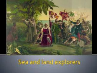
Land Reclamation By Sea Proudly done by: Ooi Kang Hao, Bryan Kheh, Matthew Seah and Quah Woei Jin CONTENTS Introduction of land reclamation What is empoldering Empoldering in the Netherlands Resources Introduction of land reclamation What is Land Reclamation?

E N D
Land Reclamation By Sea Proudlydone by: Ooi Kang Hao, Bryan Kheh, Matthew Seah and Quah Woei Jin
CONTENTS • Introduction of land reclamation • What is empoldering • Empoldering in the Netherlands • Resources
Introduction of land reclamation • What is Land Reclamation? A process of increasing the amount of usable land. • Reasons for land reclamation. -increasing demand of land -growing world population -need for recreational facilities • Ways to increase land -Bringing unused land (etc. hills, deserts, forests) into use. -creating new land by sea -restoring damaged lands FOR MORE INFO... Visit this website:www.uweb/waterland.shtml
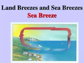
What is Empoldering Empoldering refers to the creation of polders. A polder is a piece of land in a low lying area reclaimed from a body of water by building dikes and by drainage. Empoldering can be carried out in coastal and inland areas such as lakes. Features of polders • Polders are enclosed by dikes to keep out the sea. • To prevent the polders from being waterlogged, they are managed by drainage canals and pumps. Dikes protect the polder from erosion Drainage canals carry away excess water from the polders
Major characteristic on polders reclaimed in the 17th century in north of Amsterdam • lowest lying polders, "droogmakerijen", low constant water levels are maintained because of the intensive agricultural use, which is possible because these polders have a clay soil. • higher lying polders, "veenweides" or peat pastures, relatively high constant water levels are maintained.Otherwise, the peat oxidises and the land surface subsides even more. Peat pastures are used for extensive agriculture. A typical pasture area with high water levels and extensiveagriculture.
3)Empoldering in the Netherlands • First, a dike is constructed around the area to be reclaimed to keep water from coming in. The water in the reclaim area is replaced with freshwater. • Secondly, pumps and drainage canals is used to drain the area. • Thirdly, reeds are sown to help the soil absorb excess water in the soil. • Three years later, the reeds are burnt. Drainage pipes are constructed. Ploughs are used till mix the fertile ash into the soil. • After around 15 years, the polder can be used for growing crops, building houses and constructing roads. Method Of Empoldering
Dam Reclaimed Area Of Netherlands Reclaimed land Zuider Zee
Netherlands • In 1986, the Netherlands did not carve out the province from already existing land nor did they annex the territory of their neighbours - Germany and Belgium. The Netherlands actually grew. • The Frisians, who first settled in the Netherlands began to build the terpen, the first dykes to hold back the water. • In 1287 the terpen that had held back the North Sea failed and water flooded the country. -A new bay called Zuider zee was created over the former farmland. - The Dutch worked to slowly push back the water of the Zuiderzee, building dykes and creating polders. - Once the dykes were built, canals & pumps were used to drain the land. -From the 1200s, windmills were used to pump excess water off the fertile soil; today, most of the windmills have been replaced with electricity- and diesel-driven pumps. About
Netherlands • Then, storms and floods in 1916 provided the impetus for the Dutch to start a major project to reclaim the Zuider Zee. From 1927 to 1932, a 30.5 km long dyke called Afsluitdijk (the Barrier Dyke) was built; turning the Zuider Zee into the IJsselmeer, a freshwater lake. • The Zuider Zee could not accommodate the bigger sailing ships that had been just developed. • With the Zuider Zee reclamation project, the area had many uses. • Portions of the lake were enclosed by dikes and drained to form polders. They were then used for housing, agriculture and recreational purposes. • The Ijssel Lake now serves as a freshwater reservoir, supplying water for the irrigation. Further protective dykes and works were built, reclaiming the land of the IJsselmeer. The new land led to the creation of a the new province of Flevoland. About
Netherlands • The Zuider Zee Project was so successful that empoldering is now used in many parts of the world to control floods or to increase land supply. About FOR MORE INFO... Today, approximately 27 percent of the Netherlands is actually below sea level. This area is home to over 60 percent of the country's population of 15.8 million people. The Netherlands, which is approximately the size of the U.S. states Connecticut and Massachusetts combined, has an approximate average elevation of 11 meters (36 feet). The Netherlands ties Lemmefjord, Denmark for claim to the lowest point in Western Europe - Prince Alexander Polder lies at 23 feet (7 meters) below sea level.
Pictures of the Zuider Zee Project This defence line is the only example of a fortification based on the control of water. It was built between 1883 and 1920 and extends 135 km around the city of Amsterdam. The protection of the center of the country was ensured by a network of 45 forts and their artillery acting in concert with temporary flooding from polders and an intricate system of canals and locks.
The Wouda Pumping Station is the largest steam-pumping station ever built. It opened in 1920 and is still in operation. Droogmakerij de Beemster (Beemster Polder) The oldest area of reclaimed land in The Netherlands. Mill Network at Kinderdijk-Elshout
Can Empoldering be used in Singapore Empoldering cannot be used in Singapore • The sea around Singapore is deep. • It may harm marine life and endanger them. • There is no narrow water way to build a dam. • It takes too long a time to use empoldered land.
Can land fill method be used in the Netherlands? Land fill can be used in the Netherlands • The Zuider zee is shallow enough. • It takes a shorter time than empoldering.
4)Resources • Geography Textbook • Internet Thank You Picture of Mill Network at Kinderdijk-Elshout