Download
1 / 32
320 likes | 326 Vues
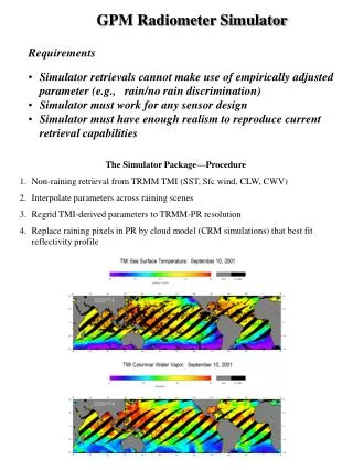
This presentation discusses the development of the Hurricane Imaging Radiometer (HIRAD) using a systems engineering approach. It explores the key focus of hurricane intensity research, operational ocean surface vector wind requirements, and the responsibilities of the HIRAD team. The presentation also highlights the technology used in the HIRAD instrument and proposes next steps for its deployment and testing.

E N D
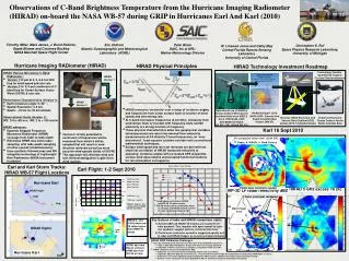
Development of the Hurricane Imaging Radiometer (HIRAD) Using a Systems Engineering Approach 61st Interdepartmental Hurricane Conference 6 March 2007
Systems Engineering Approach Developer Solutions Scientific Systems Engineering Customer Requirements Innovative NASA Technologies HIRAD Team Ocean Surface Vector Winds
Call for Improved Understanding and Predictability of Hurricane Intensity • Key focus of Hurricane Intensity Research Working Group of the NOAA Science Advisory Board - to reduce the error in 48-hour intensity forecasts for hurricane-strength storms by at least 10kt within the next five years • High priority of National Science Board (NSB) report, “Hurricane Warning: A Critical Need for a National Hurricane Research Initiative”- Predicting hurricane intensification and size, and reducing the uncertainty associated with where and when hurricanes will make landfall • Key operational forecasting needs outlined by Joint Action Group for Tropical Cyclone Research – Intensity, Structure, Track, Sea State, Storm Surge, Precipitation, Observations
NRC Decadal Study • QuikSCAT is aging beyond its expected life span • NASA/NOAA should develop better collaborations • NOAA should assume responsibility for the next operational scatterometer • NASA should explore innovative remote sensing technologies • Venture class of satellites • Suborbital demonstrations
Operational Ocean Surface Vector Wind requirements summary • All-weather retrievals (i.e. accurate retrievals in rain) • Accuracy levied upon the selected 10 meter 1 minute sustained wind • 4-165kts wind speed range • 10 -165kts: +/- 2 kts and +/- 10 degrees (2 sigma) • 4 -10kts: +/- 2 kts and +/- 20 degrees (2 sigma) • Revisit time interval: every 6 hours (1-3 hour goal) • Reduced product latency: 45 - 60 minutes from measurement to product availability (15 min goal) • < = 2.5 km horizontal grid resolution (1 km goal) • < = 2.5 km from coast (1km goal) • Wind fields must be delivered into the operational environment, i.e., NAWIPS, AWIPS and data assimilation systems • Product documentation / tutorial / training
HIRAD Team Responsibilities • NASA Marshall Space Flight Center – Project Science and Systems Integration • NOAA Hurricane Research Division – Hurricane Expertise • University of Central Florida – Modeling and Algorithm Development • University of Michigan – System Design and Calibration • RTI – Antenna Array Design and Analysis
SFMR wing pod Horn Antenna Electronics Measurement Heritage SFMR SFMR Tb for Hurricane Katrina SFMR on NOAA WP-3D Aircraft Partners: NASA LaRC, UMass., NOAA HRD, and ProSensing
Innovations from the NASA Earth Science Technology Portfolio • Instrument Incubator Program Synthetic thinned array antenna and correlated receiver technologies utilized by the Lightweight Rain Radiometer (LRR) Agile Digital Detection for RFI mitigation • Advanced Information Systems TechnologyProgram Sensor Management for Applied Research Technologies (SMART) On-Demand Modeling (ODM) for flexible, autonomous integration of Earth observations and model results during real-time decision-making
LRR-X Deployed on NASA DC-8Engineering Demonstration of Imaging • Point Reyes National Seashore, CA DC-8 nadir video camera (upper left) LRR-X TB image at 10.7 GHz, H-Pol (upper right)
Observing Strategy Roadmap Sensor Web Today Sensor Web Tomorrow
HIRAD Instrument Description • Multi-frequency (4-7 GHz) interferometric radiometer • Synthetic thinned array technology • Push broom imager with wide (+/- 60 deg) cross track field of view • Low profile planar array antenna • Software beam forming with no moving parts • Internal hot, cold, and noise diode based calibration • Continuous gap free imaging • Real-time wind and rain retrieval algorithms with one second update at 1 km spatial resolution • Sensor web enablement (SWE) technology based on Open Geospatial Consortium protocols
Technology Investment Roadmap Unmanned Aerial Vehicle Demonstration (optional) Satellite Demonstration of Improved Hurricane Ocean Surface Vector Winds and Rain Rate Aircraft Demonstration Technology Transfer Operational Reconnaissance Hurricane Aircraft (optional) Technology Brassboard Demonstration in Laboratory
Next Steps • NASA MSFC Investment funding Laboratory and anechoic chamber testing of antenna Brassboard demonstrations of full system Modeling simulated observations NOAA AOC assistance with off-nadir SFMR demo Observing Systems Simulation Experiment with HWIND Full aircraft system development • Proposals for competed funding Aircraft integration and test flights Field deployments in hurricane scenarios
Planning for SuccessReplacing Hurricane Floyd simulations with real observations Simulated aircraft wind speed observations Simulated aircraft rain rate observations Simulated rain rate product at 1 km Simulated wind speed product at 1 km
STAR Technology Heritage • ESTAR • Soil Moisture • David LeVine, GSFC • w. U.Mass. • LRR • Rainfall • Chris Ruf, U. Michigan
Original HIRADTechnology Road Map Tasks Now Modeling and trade studies Dual Linear Array/Integral Feed Test Article 16 Element Partial Array } or or Near Term 32 Element Full Array HIRAD Aircraft Instrument LRR Technology 2 – 3 Years
Current HIRAD Partners • University of Central Florida: • Linwood Jones and James Johnson • University of Michigan: • Chris Ruf and team • RTI: • M.C. Bailey and Chi Nuygen • NOAA Hurricane Research Division: • Peter Black and Eric Uhlhorn • NASA MSFC: • VP61: Robbie Hood, Frank LaFontaine, Tim Miller • VP51: Karen Stephens • EI51: Mark James • UAH: David Simmons and Sue O’Brien • USRA: Vanessa Rohwedder
Satellite Hurricane Imager Microwave Radiometer • Hurricane Winds and Rain • Instrument Development Partnership NASA NOAA UCF U. Michigan
Wind Analysis Examples NOAA HRD Hurricane Wind (HWIND) Analysis for Hurricane Katrina QuikSCAT information for Hurricane Erin compiled by Remote Sensing Solutions
NOAA SFMR 29 Aug 0930 UTC Air Force 29 Aug 0930 UTC
Original Hurricane Imaging Radiometer Team (HIRAD) Mr. James Johnson CFRSL Project Management Dr. Linwood Jones CFRSL Algorithms and Modeling Wide Swath Imaging of Strong Wind and Heavy Rain Hurricane Conditions Dr. MC Bailey RTI Array Design and Analysis Prof. Chris Ruf U- Michigan System Design and Calibration
Heritage Stepped Frequency Microwave Radiometer/ 4-7 GHz non-scanning instrumentation developed at LaRC and currently flown on NOAA P-3 and USAFR 53rd WRS C-130 Lightweight Rain Radiometer/10 GHz developed with NASA Instrument Incubator Program funding NASA MSFC and LaRC aircraft instrument development expertise NOAA and NASA aircraft hurricane sampling expertise and collaborations NOAA is establishing a requirement for improved hurricane wind observations
HIRad Concept NOAA’s Gulfstream-IV SP SFMR Swath HiRad Swath Top Side HIRad Array Element Concept Concept • HIRad offers wide swath and high resolution imaging from Gulfstream IV or a UAV. • Potential for spaceborne application. Technology • The multi-frequency, microstrip, stacked patch, thinned array is the technology challenge for HIRad. HIRad wind speed simulation of Hurricane Floyd
Strategic Planning • Technology Demonstration • Laboratory brassboard demonstration at NSSTC • Definition of design, testing, and performance requirements • Aircraft Demonstration • Fast track technology demonstration on NASA ER-2, DC-8, or NOAA P-3 in non-hurricane conditions in 2008 • Operational Aircraft Reconnaissance • NOAA P-3, G-IV, or USAFR C-130 • NASA/NOAA UAS (Global Hawk, Predator, Airship) • Satellite Demonstration • Small special-focus satellites for temporal coverage • Sensor web enabled
Updated Project Activities • HIRAD simulations and physical-based emission models • Opportunity to collect off-nadir information on P-3 • Opportunity to develop skill in Observing Systems Simulation Experiment • Antenna design and testing • Opportunity to start dual-polarized design during coming months
0 R Nadir EIA= 0+ R Antenna Off-set Angle 0 = 50 deg. A/C Roll Angle R = ± 30 deg. Measurement Request To Complete HIRad Radiative Transfer Model Surface Emissivity Incidence Angle Dependence EIA Roll Angle Plane
Wind Hurricane Eye-wall SFMR Hurricane Aircraft Maneuver
3D Hurricane Winds- Competition/Collaboration • WP3D Tail Doppler (now)- 3D winds over 80 km swath from 1-10 km alt. in precipitation regions only (NOAA) • GIV Tail Doppler (2008)- 3D winds over 40 km swath from 5-18 km alt. in precipitation regions only (NOAA) • Satellite Doppler (2020)- 3D winds from 1-20 km alt over 500 km swath similar to TRMM coverage (NOAA/NASA) • Satellite Scan SAR (2013)- Surface winds over 500 km swath similar to TRMM coverage (NASA/JPL) • WP3D ARAP (2008)- Dual mode Doppler profiler/scatterometer ( Big & Heavy). 20 km wind swath width (surface to 5 km alt) from 10 km alt. Saturates at 40 m/s (CAT2) winds. (NOAA/RSS) • Global Hawk HWrap (2012)- AUV based dual mode Doppler profiler/scatterometer (light and compact). 20 km wind swath width (surface to 10 km alt) from 20 km alt. Saturates at 40 m/s (CAT2) winds. (GSFC/RSS) • Lagrangian Drifters- pillow size balloons to map winds (1-20km alt point source with 5 day lifetime, I.e. continuous in time): winds, temperature, humidity throughout hurricane with 95% chance max wind detection with 500 balloons (ENSCO Corp.)