Download
1 / 10
100 likes | 207 Vues
Who built the Weyerhaeuser Forest Trail. F OREST T RAIL Interpretive Program.

E N D
Who built the Weyerhaeuser Forest Trail . . . FOREST TRAIL Interpretive Program The Weyerhaeuser Forest Trail was a joint effort between Weyerhaeuser Canada and the Wapiti Nordic Ski Club. In the summer the trail is intended for public use, for the Grande Prairie community, especially for schools and organized groups. In the winter the trail is used for cross-country skiing and is maintained by the Wapiti Nordic Ski Club. Weyerhaeuser provided the equipment, materials and employees to complete the initial clearing and trail development. The equipment that was used included feller bunchers, skidders, delimbers and tractors – all operating with the utmost of care to create a soft footprint on the landscape. All wood removed during the development of the trail was utilized. The Wapiti Nordic Ski Club provided labour to complete the removal of vegetation, surfacing of the trail and grass seeding. The Wapiti Nordic Ski Club Race Team played a significant role in this work. Many thanks to all of the Weyerhaeuser employees, Wapiti Nordic Ski Club families and volunteers that were involved in this project. Peter Boutilier, a Weyerhaeuser Forester and longtime Ski Club member, designed the Weyerhaeuser Forest Trail and led this project. The trail was built during the summer of 1996. Tours of the Weyerhaeuser Forest Trail . . . The Weyerhaeuser Forest Trail, along with this booklet, is designed for visitors to take a self-guided tour. If the main gate is closed, you may park in the upper parking lot, approximately 150 meters west on the County road from the main gate, on the north side of the road. There is a trail entrance across the road from this parking lot. For more information or to book a guided tour of the Weyerhaeuser Forest Trail, please call: Deb Lucas Forest Educator Grande Prairie, Alberta 780-513-9799 Email: dlucasfe@telus.net 2000
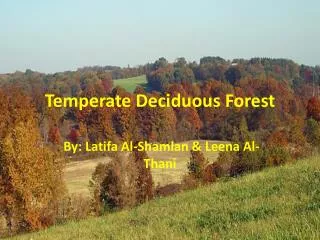
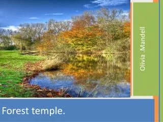
A trail for all seasons . . . The Weyerhaeuser Forest Trail was developed in the summer of 1996. The trail winds through five kilometers of boreal forest ranging from bogs and marshes to pine dunes, mixed wood forests and old-growth aspen stands. The trail was created by Weyerhaeuser Canada, in partnership with the Wapiti Nordic Ski Club and is located at the Wapiti Nordic Centre, six kilometers south of Grande Prairie on Highway 40. During the winter the Weyerhaeuser Forest Trail serves as a scenic recreational cross-country ski trail providing enjoyable experiences for all skill levels. In the summer the trail is used for hiking, walking and running with opportunities for picnicking. In addition, the trail system is available as an interpretive forest trail covering a wide range of eco-types, forest and wildlife features and forest succession stages. Through the use of this interpretive trail you will have the opportunity to increase your knowledge and understanding of the boreal forest. Please join us for a walk. Safety first . . . Please use common sense as you walk along the trail. Do not light matches or fires in this area. Stay on the trail for your own safety and to help protect the sensitive soils and plant life. As windthrow and tree breakage are common events in any forest, use of the trail on very windy days is not recommended. Standing snags (dead trees) are also common. Please be careful not to push on these types of trees. Talking is recommended so that you do not surprise wildlife. Always give yourself enough time to enjoy your walk and return before dark or if the weather looks bad. Ensure that someone knows where you have gone. Use the trail at your own risk. Every effort has been made to make the trail as safe as possible, however, unsafe behaviours can cause accidents. Please think and act safely. Pond Creek that drains the bogs that you are now passing. The trail continues to the west along a low-lying, mixed wood ridge. You will see more recent fire stumps and charred logs from a fire that occurred about 35 years ago. Several thick stands of black spruce grow beside the trail. The trail turns south and crosses a floating bridge before climbing the pine ridge and heading east. Early in the year, the large, water-covered area in this bog provides homes and nesting habitat to many species of wildlife. The bog is mostly dry in late summer. As you travel along the dune over the Wapiti Summit, look to the south to see mixed wood stands transitioning into pure aspen stands overlooking the Wapiti Valley. Further along, the trail drops down into the pure aspen with great views of the valley. At this point you will notice considerable aspen deadfall on the ground. This aspen stand is old and the trees are falling down, providing space and light for new trees to grow. This is part of the natural cycle. A slight turn up the hill brings us to Birch Hill. This is one of the few, purer stands of white birch along the trail. If you look closely you will see a number of animal dens in this area. The trail follows the bottom and eventually climbs over the large sand dune. Notice the growth on this dune. Examine the ground vegetation and large ant nests where the trail begins to climb the dune. A side trail at this location takes you to Wapiti Lookout and a picnic table. You will have a great view from here. Once over the dune, you are back into the cooler, moister, mixed wood on the north-facing slope where the Valley Loop trail again joins the main trail system. Notice the various game trails that frequently cross the Weyerhaeuser Forest Trail. Fire scars are commonly seen on the growing pine trees. You can see many examples that pileated woodpeckers have been at work throughout the area. You can see that various tree and plant species prefer or require specific soil types, moisture amounts and degrees of sun or shade. Try to observe these differences as you walk the trail. 16 1
The trail heads toward Frog Pond Creek, a relatively open, mixed wood forest to the left and black spruce and swamp to the right. Frog Pond Creek drains the bogs to the west. This creek flows high in the spring. In late summer and fall this creek may dry up. As you pass the creek you are back in the pine forest and the trail turns to the east. Just past this intersection a side trail takes you south to the Wapiti Lookout and a picnic table. You have a great view of the Wapiti Valley from here. As you return from the side trail, head north where you again cross the creek. Here you will see a larger channel with higher banks. This is only a short distance downstream from the first crossing. The trail follows along the mixed wood that has some pure pine stands on the right, to the intersection with the two kilometer trail. At the four kilometer sign post, the Enchanted Forestloop heads to the east, then turns south. At this point you can see the start of a pure aspen stand that runs east across this ridge and follows down the south-facing slopes. The trail follows south of the aspen stand through mixed wood and parallels the lower reaches of Frog Pond Creek. This portion of the creek has a large channel with 10-meter banks. Further along you pass Bear Claw Corner. At this corner you can see many large aspen trees that have significant bear claw markings. Imagine the size of these bears! The trail follows along the top of the ridge. If you look to the south, down the slope and through the pure aspen – the view is very nice. At Sleepy Hollow you have the opportunity to rest at the picnic table. Also at Sleepy Hollow you can see the higher pine ridges to the north, the aspen and alder stand to the east, the mixed wood to the west and the pure aspen stands down the hill to the south. This location is a good example of vegetation diversity. The trail continues north, then west through mixed wood with a high component of alder along the lower slope of the pine ridge. Notice the vegetation types on the dunes to the right. Can you see the cranberries? What likes to eat these berries? The trail now enters a picturesque stand of older, very large pine just before turning south, then west again at the Great Divide. This is a very interesting area, with a distinct line running east and west between the pure pine on the north and the pure aspen stand on the south. The trail continues through the pine and joins with the three kilometer trail ahead. Notice the large, dead snag along the way. What do you think would live in this snag? The Valley Loopcontinues to the west at the far south intersection. On the left you will see large, high sand dunes covered with pine forest. Ahead the mixed wood transitions to bog and the upper-reaches of Frog A brief history of the area . . . The sandstones and shales which form the bedrock in this area were deposited from 65 to 135 million years ago during the Cretaceous Age. This bedrock belongs to the Wapiti Formation and was deposited in a fresh water environment of lakes and streams. Bedrock can be observed at many locations along the Wapiti River Valley where the river has washed away the surface soils. From about 10,000 to two million years ago this region was over-ridden by the Laurentide Ice Sheet which advanced from the northeastern part of the continent. As this ice sheet travelled it eroded and mixed the materials from the bedrock producing large, flat surfaces by filling river valleys and other depressions. The surface soils in the Weyerhaeuser Forest Trail area are predominantly sandy, with some sand dunes developed adjacent to the Wapiti River. These sands originated from glaciers and were deposited as shoreline materials along rivers and lakes, or were wind-blown. Most of these sands were deposited during glacial and post glacial periods. The surface sands cover other finer deposits of clay and clay tills. Groundwater doesn’t drain efficiently through these clay layers. This creates bogs and swamps. Some of the sandy soils present in the area are vulnerable to both wind and water erosion, so please stay on the trail and do not disturb the banks. Intermittent small streams throughout the trail area drain toward the Wapiti River. During the past 100 years two significant influences have helped shape the current landscape in this area. First, forest fires have played a major role in the development of the present forests. Fire scars on living trees, old fire stumps and burned logs can be seen throughout the area, especially along many of the dunes and in the pine stands. Secondly, and to a lesser extent, human development and use of the area can be seen in the many old trails and stumps scattered about. These stumps are probably the remains of trees that the early pioneers used for house and barn construction. 2 15
The trees in this area are older and are beginning to fall down. This makes room for new, healthy trees. Even so, healthy spruce trees can blow over in high winds when the soils are saturated. As you can see on several overturned spruce in this area, the roots of the spruce are very shallow and wide-spreading. If you continue west past the second intersection, you will enter the Caribou Alleyloop. The trail passes through a pine stand that has significant lichen development. Be sure to stay on the trail or you may damage this vegetation. You will see a large bog to the north, and depending on the time of year, this bog may be filled with water. Notice the tree types around this bog and how they change as you move onto the better drained soils up to the pine ridge. The trail follows along to the south before turning east onto another pine ridge. Along this ridge you will see dense, black spruce growing in the swamp to the south. As you leave the ridge you enter some alder thickets just before turning west. Black spruce has blown over in this area over time. Just ahead you will see Woody’s Trunk. This is a resilient, old pine tree who’s main stem snapped during a windstorm, then continued to grow from several branches. Wildlife, specifically pileated woodpeckers, thrive on damaged trees such as this. Notice wildlife signs on the trees in this area. Look for the impact these woodpeckers have madeon thelarger,older pine trees. A scientific glimpse of the boreal forest. . . with smaller younger pines in the same area. These older pines survived past fires. Along the dune past Alder Grove, the trail turns to the north and then west again. If you look to the north you will see a tamarack bog through the trees. Further along, the trail passes through dense black spruce and by Tamarack Swamp on your right. The tamarack is a conifer tree but is not evergreen – it looses its leaves in the fall. When the needles on these tamarack trees turn golden brown, they look brilliant in the sunlight. Past this swamp the trail passes through several mixed and pine stands, turning south at the next intersection. Turning left at the Fox Run intersection, the trail passes a bog on the left, then climbs up onto and follows along a pine ridge to a picnic table. From this location, to the north, you can see wet soil tree species surrounding the small bog and mixed wood lower down, between the two ridges on the south. After leaving the ridge, the trail drops down to a mixed wood stand continuing into a spruce swamp. Further along at Russ’s Revenge, the forest type consists of black and white spruce in combination with alder, willow and a carpet of moss. In the summer the temperature is considerably cooler in this area. Also, soil moisture is much higher and you can see different plants growing here including the carpet of moss. You will also see considerable windthrow along this trail just before it joins back to the Bunny Hop trail. Three of the eight major forest regions of Canada are represented in Alberta. The majority of Alberta’s forests are in the boreal forest region with a smaller percentage in the sub-alpine and montane forest regions. The Weyerhaeuser Forest Trail falls within the boreal region. Forests are complex, dynamic ecosystems that continually change in response to environmental fluctuations. The Weyerhaeuser Forest Trail passes through a complex, interacting system of living plants, animals and microscopic organisms, with a soil, an atmosphere and a microclimate. There are also various types of organic matter, in different stages of decay. The diversity of the forest reflects its history of natural disturbances, from fire to insect infestations, to wind storms. Forests burn naturally following thunderstorms and lightning activity. The occurrence of a forest fire is dependent on many factors, such as: the age of the forest, the dominant tree species and the local weather conditions. Fires may burn the plants and litter on the forest floor or they may consume the whole forest spreading from tree top to tree top. After a fire, the forest renews itself. A new forest begins with fast growing, young trees and plants that grow in the nutrient rich soil. Forest fires are a natural part of the life cycle of the forest ecosystem. It is this type of periodic renewal that has shaped the current patchwork of plant species in this forest. These patches vary in size, composition, age-structure and distribution. Depending on site-specific environmental conditions (e.g. soil, topography), plant and animal species occur in different assemblages (communities) depending on the stage of development of the forest. The number and the type of species that can be found in any place depends on the local vegetational mosaic. Soil conditions and topography, and the time that has passed since disturbance, determines the complexity and composition of plant communities. This complexity creates numerous structures that provide habitat farourable to a large number of species. Each habitat condition, or combination of habitat conditions, can support a different community of plant and wildlife species. Some species are associated closely with a single habitat characteristic, while others are found over a range of conditions. Often, it is these specific habitat characteristics that determine the presence or absence of a species. For instance, naturally occurring fires may leave large, living trees or a large number of snags (large, dead wood) that provide habitat opportunities for cavity-nesting birds. Old, decaying trees in a yet unburned, mature forest will provide feeding opportunities for woodpeckers. Fallen, decomposing logs not only contribute to the nutrient recycling of the forest floor, but offer habitat opportunities for insect species that may be critical to soil productivity and the food chain of the ecosystem. Early stages of a renewing forest provide many foraging opportunities for deer. Watch closely for the different habitat conditions along the forest trail. 14 3
Take a hike on the Weyerhaeuser Forest Trail . . . Vegetation types of Alberta boreal forests . . . The Weyerhaeuser Forest Trail is designed in a series of one kilometer loops. The intersections are clearly marked and you can choose to walk one, two, three, four, or the entire perimeter of five kilometers. Many features along the trail have signs to identify points of interest and assist you in determining your location on any particular loop. You can refer to the enclosed map as you plan your walk. Each loop has many different and interesting features. Read on to learn more about what you may see. The Bunny Hoploop starts in a spruce stand at the Wapiti Nordic Centre and travels west, up the hill through primarily mixed wood forest to the first south turn. Here you will find a huge tree named Tamarack Tom. Although tamarack trees seldom grow to this size, this is an example of a tree that found the perfect growing site and took advantage of it. Travelling along this trail you pass through mixed wood forest with the occasional, smaller pockets of willow and alder. At Disappearing Lake there is a larger stand of aspen and poplar mixed with scattered willow and alder. This is a unique area, completely covered in water during the spring months. This area dries up and provides marginal tree growing conditions during the summer and fall. Continuing on, you will notice pine stands ranging from moderately-open to open density on the sand dune to the left of the trail. Notice the lichen development and plant growth on this sandy, well drained site. On the right side you will see mixed wood transitioning to spruce, then poplar, alder, willow and bog. At the first intersection, the trail turns left, crosses over the pine dune and heads back along the lower slope of the dune to the east. The forest cover to the south along this trail transitions from black spruce swamp to a pure stand of aspen. At Seeping Spring you can see a balsam poplar (and some other indicators of moister soil) growing on the lower slope of the dry sand dune. There is actually an underground spring in this area providing moisture for this vegetation. Further along, the trail climbs back up onto the dune and follows the old game trail through mixed wood and spruce to the trailhead. This trail is one kilometer in length and can be covered in a relatively short period of time. The Fox Runloop continues on at the first intersection. There is a distinct difference in forest type along this trail with the pine forest on the better drained, sandy dune to the left, and the spruce transitioning to deciduous and bog on the right. Further along at Alder Grove you will notice several unique features. First, there is considerable alder growth under the pine stand, which forms an interesting cover type. Second, as you continue along in this area you will see many old fire scars on the larger, living pine trees Most of our forested areas in Alberta are a result of past wildfires. There are many different forest associations (groups of trees, shrubs and mosses) that can be found throughout the trails at the Wapiti Nordic Centre. A brief description of some of the commonly used words... Forb (herb)– small plants that grow within 30 centimeters above the ground. Duff layer– is the build-up of leaves, needles, small twigs, etc. It is the forest’s natural “composting”. Earthworms and other soil organisms work to help break down and decay this layer – releasing vital nutrients and minerals back to the soil and plants. Overstorey– is the upper tree layer in the forest. We also talk about it being the “Canopy” layer. Understorey– is the shrub, herb and moss layer in the forest. Tree– a plant with one main central trunk with branches more than three meters tall at maturity. Shrub– usually bush-shaped, multi-stemmed (rather than a central trunk) and less than three meters tall at maturity. Plant species commonly found along the trail . . . • Shrubs • Canadian buffalo-berry • High bush cranberry • Red-osier dogwood • Saskatoon • Wild raspberry • Wild rose • Bearberry • Blueberry • Twinflower • Forbs • Bunchberry • Fireweed • Horsetail • Wild strawberry • Conifer trees • Lodgepole pine • White spruce • Black spruce • Tamarack • Deciduous trees • Balsam poplar • Birch • Trembling aspen • Bog/wet area shrubs • Bog cranberry • Bog rosemary • Labrador tea • Small bog cranberry • Alder • Willow Look carefully and see how many species you can identify. Where do they typically grow? What wildlife do you find in association with these plant species? 13 4
Mixed wood forests White spruce and trembling aspen commonly grow together across the boreal forest – sometimes we call this a “mixed wood forest”. Mixed wood forests also commonly include black spruce, lodgepole pine, balsam fir, balsam poplar and birch trees. White spruce is a large, conifer (evergreen) tree with a long life span. Its needles are dark green, short (two to three centimeters), sharp-pointed, and grow from all sides of the twigs. Its branches are long, sweep down, and usually grow right from the ground level up to the top. White spruce produces cones each year that have papery scales which open to release the seed each fall. Spruce trees have several main roots that spread out for three meters or more in all directions, but stay close to the surface (within 50 centimeters) of the ground, as compared to pine that has a very deep tap root. The spruce tree is called “shade tolerant”, which means it does not need full sunlight to grow; in fact, its seedlings grow best in a somewhat shaded environment. It grows on moister sites where there are typically a lot of other plant species. Watch out for wildlife . . . There are over 100 species of birds that live in or pass through this area. Some of the more interesting inhabitants include hairy, downy and pileated woodpeckers, gray and great horned owls, yellow-bellied sapsuckers, black-capped chickadees, northern flickers, white-breasted nuthatches, and ovenbirds. Purple finches, various sparrows and hawks, crows, ravens, robins, ruffed and spruce grouse, and blue and Canada jays are commonly seen. Occasionally you’ll see nesting pairs of ducks in the bogs. The bogs are home to some amphibian species including a great number of frogs that can be heard croaking loudly at certain times of the year. Beware, the trail is also home to many insects including large numbers of the dreaded, giant mosquito. Which, if given the opportunity, will carry you home for supper– so dress and prepare accordingly. As you walk along the trail look closely for signs of wildlife. These signs could include dens, tracks or droppings, rub-trees, squirrel caches, bark removal on trees by porcupines, evidence of woodpecker or insect activity, fallen feathers, or even bear claw markings on the trees. Also look and listen carefully, you may see some of the wildlife that made these signs. trembling aspen Trembling aspen is a large, deciduous tree (sheds its leaves each fall). It has tight bark that is white or greenish-white in colour. Usually, it has one main trunk with small branches in the upper part of the crown. It is not shade tolerant – it needs full sun to grow best. This is why it does not have branches all the way down the trunk. The leaves on aspen are fairly small (up to 8 centimeters long) and are triangular-shaped. The petiole (leaf stem) joins the leaf to the branch and is usually red. It is always flattened at the base of the leaf. This causes the leaves to “tremble”, even in a small breeze. This is the reason it was named Trembling Aspen. Aspen is well-known for its suckering ability. The roots of the trees have small “buds” that remain dormant as long as the main trunk of the tree is alive and producing growth hormones. When the main stem is removed, the root buds are triggered to develop and grow up through the ground – what we call “suckering”. The aspen tree has evolved over time to have this very efficient survival strategy. The roots store food reserves that sustain these suckers until they have leaves of their own that can produce photosynthates (food). Common animals in the area include red squirrels, snowshoe hares, mule and white-tailed deer. The occasional moose can be seen in the bogs. From time to time porcupines eat bark on the trees along the trail and black bears do pass through. Fishers, pine martin and weasels also live in the area. There have been reported sightings of sasquatch, on skis, travelling at a high rate of speed. white spruce 12 5
After a fire, aspen will immediately colonize a site. (After a fire, the conditions are hot, dry and exposed to full sunlight, which aspen love). Due to its suckering ability, the aspen can quickly colonize an area and form a stand of aspen. Each fall, mature, white spruce from neighbouring forests will seed these exposed areas. Some of the seeds will germinate and grow under the aspen suckers (in the shade). Over time, the aspen stands become old, die, and blow over (around 110 years) leaving the spruce. The forest may change to become a pure spruce forest. Spruce can live more than 250 years. Shrubs commonly found in the understorey of mixed wood forests include cranberry, dogwood, buffalo-berry, saskatoon, rose and raspberry. The Forb Layer may contain bunchberry, bearberry, strawberry and horsetails. in a one meter square patch). This is extremely dense, and there is huge competition between the trees – for sunlight, soil moisture and nutrients. This leads to a natural thinning (a process by which the least vigorous or healthy trees will die off, leaving more space for the remaining ones). Aspen goes through its first thinning around the age of five years. There may be 100,000 remaining stems. The forest stand goes through successive thinnings at various ages but by the time the trees are about 70 years old, there will likely be about 800 to 1,000 trees per hectare (or about one tree in that one meter square patch). At approximately the age of 90 years, aspen becomes over-mature and the aspen forest starts to “break-up”. As trees get old, they are not as healthy. Diseases become more common and start to decay the inside of the trees. This makes them more susceptible to insects, which attracts woodpeckers. All these things damage the tree and eventually the tree dies. The tree may remain standing or it may blow over. Either way, space is made available and full sunlight can reach young suckers. This type of forest can look very “messy”, but it is nature’s way. There is an excellent example of this on the Valley Loop trail. Balsam poplar (often called black poplar or bam) is a large, deciduous tree that is closely related to aspen. Similar to the spruces (black spruce in wet areas, white spruce on drier Common shrubs of the boreal forest . . . Cranberry Low-bush cranberry (less than one meter high) and high-bush cranberry (two meters high) have “maple-shaped” leaves that turn a brilliant red in the fall. They produce large crops of cranberries that are bright red and scattered along the stems. They are edible, but sour. Red-osier dogwood Red-osier dogwood is a large bush (one to two meters high) with bright red stems. The leaves are oval-shaped, seven to 10 centimeters long and come to a point at the end. It produces white berries in large clusters at the ends of the stems. Canadian buffalo-berry Canadian buffalo-berry is a large bush (two meters high). The stems are covered with a metallic brown scurf (little bumps all over that fall off if you rub them). The leaves are oval (not pointed), covered in scurf and about two to five centimeters long. It produces bright red berries that grow in small clusters at the ends of its branches. Saskatoon berry Saskatoon berry is a shrub that may be shaped like a bush (multi-stemmed) or can have a main trunk with large bushy branches. Its leaves are circular with small, round, serrated (cut) edges. It produces bluish-purple berries (excellent in pies). Wild rose There are two species of the wild rose that grow throughout the boreal forest. Both shrubs are about one meter high and have sharp prickles along their branches. They have beautiful, pink flowers and the leaves are compound – meaning they have five to seven leaflets joined together. The rose flowers turn into rose hips. The common wild rose will form a red, very hard, completely round hip. The prickly rose will form a red, softer, oval-shaped hip. This is the only way to distinguish between the two species. Bearberry This shrub grows almost everywhere along the ski trails – in the hot, open pine stands; under the spruce and aspen; and in the wetter, boggy areas. Although it is technically a shrub, it has forb characteristics. It grows together forming a mat over the area (usually grows within 12 centimeters off the ground). It has round, thick, waxy, dark green leaves. Often the leaves are covered with brown spots, which are actually a fungus that grows on them. In the fall, it produces a lot of bright reddish-purple berries. Deciduous forests Aspen often grows in “pure” stands, meaning other tree species are not on the same site. It will also grow in combination with balsam poplar and birch on the moister sites. If there are no surrounding white spruce stands, conifer seeds will not blow in and germinate. As described above, aspen will colonize recently disturbed areas (such as a forest fire, or a logged cutblock) and grow a forest. When the aspen first comes back there can be over 400,000 stems per hectare (over 40 stems growing 11 6
sites), aspen grows on drier sites and balsam poplar can be found in the wetter areas. It is commonly found along the creeks and river valleys across Alberta. This tree is a short-lived species, partly because the inside of its trunk rots away. Often you will see bam with a broken top that has small branches sprouting out of it. Balsam poplar has very large, football-shaped leaves (10 to 18 centimeters long). The leaves are dark, shiny green on the top and pale whitish-green underneath. Balsam poplar leaves and buds are very sticky. (Those little, sticky, brown pods that fall on your driveway in the spring are the bud scales). Older bam trees have very rough bark with deep furrows. Its bark is dead wood cells, similar to pine, spruce or fir. Compare this with older aspen trees that still have tight, white bark; the cells in this type of bark remain alive – they continue to grow and multiply and expand as the tree grows in diameter, so it stays tight and doesn’t have shaggy bark or deep furrows. Tamarack (or larch) is another tree species that grows in the bog. This is a conifer tree – but is not evergreen. Its needles turn bright yellow each fall and are shed. During the summer the needles are light green, and very soft (not sharp like spruce). They grow in clusters with 15 to 20 needles coming out of the same point on the branch (compared to spruce which are spread along the branch). Tamarack produces very small cones (about one centimeter long) that sit upright on the branches and look like little roses. To avoid competition, tamarack has evolved to live on these very wet sites with black spruce. There are several pure tamarack bogs on the Fox Run trail. There are many species of shrubs that have adapted to grow in these wet areas. Many of the “berry” plants (sometimes mistakenly called forbs because they stay close to the ground and cover it in dense mats) are actually “dwarf” shrubs that do not grow over 50 centimeters tall. Most of these dwarf shrubs are evergreen – they keep their leaves all year long (e.g. bearberry, bog cranberry, small bog cranberry and bog rosemary). One of the most common shrubs you’ll find in boggy areas is Labrador Tea. This plant grows about 50 centimeters tall and has long, narrow, football-shaped leaves that have bright orange fuzz on the underside. Taller shrubs found in the wetter areas include bog birch, willow and alder. alder Another species commonly found growing alongside balsam poplar is alder. You can see it growing in the Disappearing Lake on the Bunny Hop and in Alder Grove on the Fox Run trail. This is a scruffy-looking, multi-stemmed shrub that can grow two to three meters high. It has smooth, grayish bark that is covered with small patches of lichen and looks messy. The leaves are oval-shaped, come to a point, and are crinkly. It produces small (two centimeters), brown, wooden conelets – you often see them used in Christmas decorations. tamarack White birch Paper birch is a well-known tree. It is named for its thin, white bark that is layered around the tree. Birch bark will peel off, much like a piece of paper. In this part of the boreal forest, birch is not a common species. It is found randomly in mixed stands and occasionally in pure stands (an example is Birch Hill on the Valley Loop trail). Birch grows equally well in the open with full sunlight or in shady environments. Shrubs in the understorey of birch often include wild rose bushes. willow Willow is another shrub that tends to grow in wetter areas along creek banks. Typically, it is a smaller shrub than alder and grows to a height of approximately two meters. There are many different types of willows. Most of the types have very distinctive leaves – long (8 to 16 centimeters), very thin, and usually pointed at each end. balsam poplar birch 10 7
As with aspen stands, if there is white spruce in the neighbourhood, it will seed in under the pine overstorey and a spruce understorey can form. The pine becomes mature around 90 years of age. Around 160 years it becomes over-mature and may start to break up. If there is no disturbance (fire or logging) for a long period, the forest may become a spruce forest. Before the province instituted forest fire control systems, forests in Alberta burned approximately every 40 to 70 years. The majority of the forests were pine stands. Less spruce was seen due to their longer lifespan requirements. Now that we fight fires, our average age of forests is well over 120 years and we see a lot more spruce. Shrubs in the understorey are not very common in a dense pine stand. Occasionally you will see alder and some rose. The Forb Layer commonly contains blueberry and bearberry. Black spruce is one of the main tree species in the boggy areas. It is a slow growing, long-lived tree that has adapted to extremely wet soils (to avoid competition). It has branches that sweep down, similar to white spruce, but the branches are not as large or as long. It is common to see a big clump of branches at the top of the tree. From far away this looks like the Pope’s hat. Overall the tree is not as “nice” a form as white spruce. These trees are usually shorter than other conifer trees due to the environment they live in. The needles are short (two to three centimeters), sharp-pointed and grow on all sides of the twig. The cones have papery scales and are small (two to three centimeters) and round (compared to the white spruce, which are oblong). The cones usually grow in clumps and they shed their seeds each year. Pine forests Lodgepole pine is a common conifer (evergreen) tree in this part of Alberta. It is a large tree with a “medium” life span – longer than aspen but much shorter than white spruce. It has long needles (five to 10 centimeters) that grow in pairs. Each needle is a semi-circle – when you hold them together they form a perfect circle. The needles usually point up, towards the sky and so do the branches (they do not sweep down like spruce – they lift up to try get more sunlight to their needles). The branches usually only exist on the upper, one-half to one-third of the crown. This is because the pine tree, like the aspen, does not like shade. It grows best in high sunlight; so the thicker or denser the forest, the less branches it has. (A pine tree growing on someone’s front lawn may have branches right down to the ground because it gets a lot of sunlight on all sides. This usually doesn’t happen in the forest.) Lodgepole Pine is called a “fire species”. It has evolved a different strategy than aspen to colonize areas after a fire or logging. It has very hard, woody and “serotinous” cones which means the cone scales stay closed. They are glued shut with resin (sap) and the seeds remain inside (unlike spruce which opens up each year and lets the seeds blow out). Only intense heat will break this resin bond and allow the seeds to fall out of the cone. A fire is hot enough to break this bond. The tree burns up and the cones open during or after the fire and the seeds fall to the ground. If enough of the forest burns, there is full sunlight reaching the ground – perfect for seeds to germinate in and not have any competition. Pine is also adapted to live on the more “extreme” sites. It does not like to compete for light – so it has made other adaptations. It will live on drier sites. You will often see pine stands growing in pure sand. This can be seen throughout the Forest Trail, especially on the Valley Loop. The pine has developed a “tap root” system. The tree has one main root that grows down deep (two meters or more) into the ground seeking water (compare this to spruce). Pine may also grow on sites that don’t have as many nutrients or minerals in their soils, which may also mean there are no competing species. Black spruce and tamarack bogs You may observe a couple of types of bogs in this area – some have standing water in them. Some bogs are on seepage areas (very wet soil with a lot of peat moss that holds water) where you see standing water only after heavy rains or in the spring. Typically these bogs have a huge, spongy layer of herbs and forbs. black spruce lodgepole pine 8 9
Wapiti Nordic Centre 6 km to Grande Prairie P COUNTY ROAD Steve Cooper Lodge P Tamarack Tom Tamarack Swamp Russ Bowen’s Picnic Spot Alder Grove Disappearing Lake Hwy 40 N BUNNY HOP (1 km) FOX RUN (2 km) Old Game Trail W E Russ’s Revenge Seeping Spring CARIBOU ALLEY (3 km) Pine Ridge S Woody’s Trunk Great Divide ENCHANTED FOREST ( 4 km) Sleepy Hollow Frog Pond Creek Floating Bridge Bear Claw Corner VALLEY LOOP (5 km) Wapiti Lookout Wapiti Summit Interpretive Program Birch Hill FOREST TRAIL