Download
1 / 9
90 likes | 258 Vues
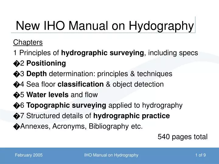
New IHO Manual on Hydography. Chapters 1 Principles of hydrographic surveying , including specs � 2 Positioning � 3 Depth determination: principles & techniques � 4 Sea floor classification & object detection � 5 Water levels and flow

E N D
New IHO Manual on Hydography Chapters 1 Principles of hydrographic surveying, including specs �2 Positioning �3 Depth determination: principles & techniques �4 Sea floor classification & object detection �5 Water levels and flow �6 Topographic surveying applied to hydrography �7 Structured details of hydrographic practice �Annexes, Acronyms, Bibliography etc. 540 pages total IHO Manual on Hydrography
1 Principles of hydrographic surveying • Survey specifications • Survey planning • Data gathering • Data processing • Data analysis • Data quality • Data quality presentation (reliability diagrams, ZOCs) • Data production • Nautical information system (compilation, presentation) • Zafaryab (Pakistan) 26 pages IHO Manual on Hydrography
2 Positioning • Principles (the earth, datum, coordinate systems, cartography, projections) • Horizontal control (triangulation, trilateration, traverse, photogrammetry) • Levelling (geometric, trigonometric, GPS) • Instruments for control (GNSS, electronic, optical) • Positioning methods (GNSS, radio, acoustic, optical) • Lamberti & di Lieto (Italy) & Lawrence (UK) 85 pages IHO Manual on Hydrography
3 Depth Determination • Acoustics (characteristics, sound speed, propagation, parameters) • Motion sensors (inertial principles, RPH sensors, heading) • Transducers (principle, beamwidth, single & multi, mounts) • Acoustic systems (single beam, swath) • Non-acoustic systems (LIDAR, electromagnetic, photbathymetry, lead line, sweep) • Freitas (Portugal) 81 pages IHO Manual on Hydrography
4 Seabed classification / feature detection • Feature detection (requirements, methods: sidescan, MBES, magnetometer, sweeps, other) • Seafloor characterization (principles, theory, methods) • Johnson (Australia) 54 pages IHO Manual on Hydrography
5 Water levels and flow • Tides (theory, support functions, methods: planning, zoning, operation, processing, datum computation, tide reducers, KGPS) • Currents (principles, measurement, prediction) • Mills & Gill (US) 48 pages IHO Manual on Hydrography
6 Topographic surveying • Topography, coastline delineation, AtoN positioning (specs, methods, coastal & harbour land surveys) • Remote sensing (photogrammetry, non-photogrammetric; satellite sensors, image processing) • Mayer & Salgado (Argentina) 108 pages IHO Manual on Hydrography
7 Hydrographic practice • Survey planning (requirements, horizontal & vertical control, sounding and sampling, coastine, other, teamwork, data compilation, checking, rendering, scheduling, costs, liason) • Reconnaissance (general, geodetic, tidal) • Data acquisition (horizontal & vertical control, environment, line layout - cross, main, inter & exams) • Coastline delineation (detail required, drying line, land heights, foreshore, coastline, air photos) • Data processing (bathymetry, feature detect, ancillary) • Data rendering (ROS, data required, format, density, media) • Wilson & Wyatt (UK) 74 pages IHO Manual on Hydrography
Appendices • Survey planning & estimation guide • Horizontal positioning systems & selection criteria • Bandwidth classification of radiopositioning systems • Radiopositioning systems in the field • System diagrams • Specimen report of survey IHO Manual on Hydrography