Download
1 / 42
420 likes | 422 Vues
This is a midterm exam covering lectures on wind balance in the upper atmosphere, including pressure gradient force, Coriolis force, and geostrophic balance. It also covers chapters 1-4 from the textbook. Remember to bring your catcard and necessary tools like a calculator and pencils.

E N D
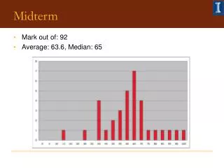
Midterm #1 on Thursday!! - Bring your catcard ~ 20 questions:- short answer, multi-choice, and problems - covers all lectures through today - covers chapters 1 – 4 from textbook You also need:- - calculator (non-programmable) - grey-lead pencils and eraser Closed exam – no textbook or notes
Midterm #1 on Thursday!! Tools for Review:- - review problem set and solutions available on d2l - also solutions to homeworks 1 and 2 - also review problems on reading list
Winds in the Upper Atmosphere:- 1. Pressure Gradient Force 2. Coriolis Force 3. Friction
Winds in the Upper Atmosphere:- L PGF PGF Balance! CF CF H
Winds in the Upper Atmosphere:- 1. Geostrophic Balance:- - When the PGF and the Coriolis force areinbalance,the wind flows parallel to the height contours at a constant speed with no change of direction (i.e., no net acceleration) L L PGF PGF In Balance! Out of Balance! CF CF H H
NH L H Winds in the Upper Atmosphere:- 1. Geostrophic Balance:- - This non-accelerating flow is called the Geostrophic flow (or geostrophic wind), andoccurs when the PGF and Coriolis force are equal and opposite.
H SH NH L L H 1. Geostrophic Balance:- - In the Northern Hemisphere, the geostrophic wind blows with lower pressure to its left and higher pressure to its right. - In the Southern Hemisphere, the geostrophic wind blows with lower pressure to its right and higher pressure to its left because the coriolis force is in an opposite direction.
Geostrophic Balance • The velocity (or speed) of the geostrophic wind is directly related to the strength of the PGF. • The weaker the PGF, the weaker the geostrophic wind. • The stronger the PGF, the stronger the geostrophic wind. • Geostrophic balance occurs when isobars are straight and parallel to each other.
Gradient Balance • Recall that in order for an object to change speed OR change direction it must have a “net force” actign on it. In Geostrophic balance there is no “net force” the PGF exactly balances the Coriolis force. When the isobars are NOT straight and parallel i.e., when they are curved, in order for the wind to still flow parallel to the isobars, it must change DIRECTION!
L H Gradient Balance:- • In order for the flow to follow curved contours, it must be constantly changing direction. • To be changing direction, there must be a net acceleration and a net force acting on the flow. • there must be a continual mismatch between the pressure gradient and coriolis forces to cause a direction change. • the flow cannot be in geostrophic balance in this situation. • instead, it is in “gradient balance”.
Gradient Balance:- • When this mismatch between the PGF and CF occurs so that the air can flow parallel to curving isobars, it is known asgradient flowor gradient wind. • Gradient flow develops only in the absence of friction i.e., at upper-levels away from the surface. • Geostrophic flow (balance) is a special case of gradient flow (balance) arising if the contours happen to be straight and parallel.
L PGF L L PGF CF CF L H L L L L Gradient Wind:- 1. Flow around high pressure - Supergeostrophic Flow In a high pressure system, there is high pressure at the center of the curved contour and low pressure on the outside. The air motion at an instant in time is tangential to the isobar The PGF is pointed away from the center of the curved contour (toward the low pressure). The CF is pointing into the center of the curved contour (at right angles to the air motion.
L L L PGF PGF CF CF H L L L L L Gradient Wind:- 1. Flow around high pressure - Supergeostrophic Flow Now, if the air is following the curved isobar, it is constantly changing direction away from the low pressure and toward the high pressure. Thus, it must be continuously accelerating toward the High pressure. There must be a net force on the air toward High pressure. Thus, the CF must be greater than the PGF. The net difference between the two is known as the inward-directed centripetal force - Ce
L L L PGF PGF CF CF H L L L L L Gradient Wind:- 1. Flow around high pressure - Supergeostrophic Flow Recall that the CF is proportional to the wind speed. For the CF to be greater than the PGF, the wind speed must be greater than that under the same geostrophic conditions (i.e., same pressure gradient, but straight isobars). Such flow is known assupergeostrophic flow.
H H H CF CF PGF PGF H L H H H H Gradient Wind:- 2. Flow around low pressure - Subgeostrophic Flow • In the case of a low pressure system there is low pressure at the center of the curved contour and high pressure on the outside. The PGF is pointed in to the center of the curved contour (toward the low pressure), and the CF is pointing out from the center of the curved contour.
H CF NH CF PGF H H PGF L Gradient Wind:- 2. Flow around low pressure - Subgeostrophic Flow For the air to follow the curved contour, it must be continuously accelerating toward the LOW pressure because it is constantly changing direction. The pressure gradient force must be greater than the Coriolis force. Again, the net difference is known as the inward pointing centripetal force, Ce For the CF to be less than the PGF, the wind speed must be less than that under the same geostrophic conditions. Such flow is known assubgeostrophic flow.
Two types of Balance for Upper-level Winds:- Gradient Flow:- three-way balance among PGF, CF, and Ce. Wind direction is parallel to curving isobars. Geostrophic Flow (special case of gradient flow):- isobars straight and parallel. PGF and CF exactly cancel each other. Wind direction is parallel to isobars.
Flow around low pressure NORTHERN HEMISPHERE SOUTHERN HEMISPHERE Counterclockwise flow Clockwise flow (because Coriolis force reverses with respect to wind direction)
There is another force balance possibility if the Coriolis force is very small or zero, so it’s negligible. In that case, the pressure gradient force would balance the centripetal force.
Cyclostrophic Balance PGF + centripetal force = 0 OR PGF = Centrifugal force L Pressure gradient balances the centrifugal force. Occurs where flow is on a small enough scale where the Coriolis force becomes negligible. Pressure gradient force Centrifugal force Important in (the really cool) meteorological phenomena that have really strong winds and tight pressure gradients!
TORNADOES Examples of Cyclostrophic Flow Inner-core of HURRICANES And the flushing toilet, too!!
The Great Mystery of the Flushing Toilet Solved! Centrifugal force PGF To Bart and Lisa: “A swirling, flushing toilet is in cyclostrophic balance, so the way it flushes depends more on the shape of the drain—and nothing to do with whether you’re in Australia or not!”
Near-surface winds:- the effects of friction - Friction makes winds near the surface slower than those in the middle or upper atmosphere, given equal pressure gradients. The lower wind speed reduces the Coriolis force, thus the flow cannot be gradient or geostrophic near the surface.
NH SH Friction Because the CF is reduced, the winds do not flow parallel to the isobars in the boundary layer, but cross them at an angle as they flow from high to low pressure. The deflection is to the right in the NH, and to the left in the SH. i.e. the direction of deflection due to Coriolis is unchanged – just the amount of deflection is less than in the upper atmosphere …
Boundary layer Upper levels Upper levels Boundary layer Friction • For high pressure systems at the surface, friction slows the wind down so that CF does not act as strongly. • cross-isobar flow outward from the center of the high (divergence) • For low pressure systems at the surface, friction slows the wind down so that CF does not act as strongly. • cross-isobar flow into the center of the low (convergence)
- The wind rotates clockwise around anticyclones in the NH as Coriolis deflects the air to the right and the PGF directs it outward. Upper levels Boundary layer Cyclones, anticyclones, troughs, and ridges • High pressure systems:- • are areas of enclosed high pressure marked by “roughly” circular isobars or height contours – called anticyclones.
Upper levels Boundary layer H 1. High Pressure Systems:- - In the boundary layer, the air spirals out of anticyclones because of frictional effects, while in the upper atmosphere it flows parallel to the height contours (gradient balance). - Because the air in the boundary layer is diverging in anticyclones, this surface air is being constantly replaced by air from above it sinking air.
1. High Pressure Systems:- Large areas of subsidence inhibits cloud formation and causes warming by compression Anticyclones typically exhibit clear skies and fair weather because of this large-scale subsidence. The divergence at the surface also causes the pressure isobars to spread apart as a general rule anticyclones are bigger than cyclones, and have weaker pressure gradients (and weaker winds).
Boundary layer Upper levels • Low pressure systems:- • are areas of enclosed low pressure marked by “roughly” circular isobars or height contours – call cyclones. - The wind rotates anticlockwise (counterclockwise) around cyclones in the NH as Coriolis deflects the air to the right and the PGF directs it inward.
L Boundary layer Upper levels 2. Low Pressure Systems:- - In the boundary layer, the air spirals in to cyclones because of frictional effects, while in the upper atmosphere it flows parallel to the height contours (gradient balance). - Because the air in the boundary layer is converging in cyclones, this surface air is being forced upwards rising air.
L H 2. Low Pressure Systems:- Areas of rising air encourages cloud formation Cyclones typically exhibit cloudy skies and often precipitation because of this organized surface convergence. The convergence at the surface also causes the pressure isobars to contract in as a general rule cyclones are smaller than anticyclones, and have stronger pressure gradients (and stronger winds).
Winds at the surface… Low pressure systems:- Closed isobar around low pressure Winds turn anticlockwise around low pressure in the NH Winds cross isobars moving toward the low pressure (converging) because of the effects of friction Isobars are spaced more closely together and thus winds tend to be stronger in a low compared to a high pressure system. Lows have a tendency to be smaller than highs
Winds at the surface… High pressure systems:- Closed isobar around high pressure Winds turn clockwise around high pressure in the NH Winds cross isobars moving away from high pressure toward low pressure (diverging) because of the effects of friction Isobars are spaced more widely apart and thus winds tend to be weaker in a high compared to a low pressure system. Highs have a tendency to be bigger than lows
3. Troughs and Ridges:- Many pressure systems occur not as closed cells, but as elongated “waves” called troughs (low pressure) and ridges (high pressure).
300 mb 500 mb 850 mb 700 mb 3. Troughs and Ridges:- Generally we see cyclones and anticyclones at the surface that gradually give way to troughs and ridges in the upper atmosphere. This is partly because of friction at the surface.
Winds in the upper atmosphere… Troughs:- - Winds turn anticlockwise around troughs in the NH - Winds follow isobars (gradient balance) Ridges:- - Winds turn clockwise around ridges in the NH - Winds follow isobars (gradient balance)
Measuring Wind:- Measure wind direction and speed northerly wind is from the north (0°/360°) easterly wind is from the east (90°) southerly wind is from the south (180°) westerly wind is from the west (270°)
Measuring Wind:- At the surface:- Wind direction is measured with a wind vane Wind speed is measured with an anemometer– rotating cups on a shaft that catch the wind and generate an electric current – the strength of the current is proportional to the strength of the wind. The two can be combined to give both direction and speed – an aerovane
Measuring Wind:- • At upper levels:- • rawinsondesattached to balloons launched twice daily are tracked by GPS to give upper-level winds. They also carry instrument packages including temperature and humidity sensors
Upper-level Wind:- The balloons continue to rise until they burst. It is possible to get a second profile as the instrument package descends (rapidly!!) back to Earth,
Upper-level Wind:- The same instrument package can be dropped out of the belly of of an airplane with a parachute attached to limit fall-speeddropwindsonde