Download
1 / 10
100 likes | 201 Vues
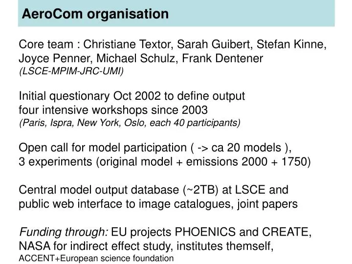
AeroCom organisation. Core team : Christiane Textor, Sarah Guibert, Stefan Kinne, Joyce Penner, Michael Schulz, Frank Dentener (LSCE-MPIM-JRC-UMI) Initial questionary Oct 2002 to define output four intensive workshops since 2003 (Paris, Ispra, New York, Oslo, each 40 participants)

E N D
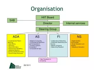
AeroCom organisation Core team : Christiane Textor, Sarah Guibert, Stefan Kinne, Joyce Penner, Michael Schulz, Frank Dentener (LSCE-MPIM-JRC-UMI) Initial questionary Oct 2002 to define output four intensive workshops since 2003 (Paris, Ispra, New York, Oslo, each 40 participants) Open call for model participation ( -> ca 20 models ), 3 experiments (original model + emissions 2000 + 1750) Central model output database (~2TB) at LSCE and public web interface to image catalogues, joint papers Funding through: EU projects PHOENICS and CREATE, NASA for indirect effect study, institutes themself, ACCENT+European science foundation
WEBSITE AeroCom Workup Structure Protocol NCDUMP NCO/ncregrid netCDF FTP submission Model simulation Model diagnostics CheckFormat ReformatRegrid feedback Storage email cp Model description excel Intercomparison Database RAID server Access feedback idl idl Scientific papers Visualisation Analysisstorage Analysis idl WWW access Image database Observational Database png divers Perl/javascript
WWW access Image database png Perl/javascript http://nansen.ipsl.jussieu.fr/AEROCOM/data.html
WWW access Image database png Perl/javascript Why we should cooperate: AeroCom tools exported to other projects (Harmonised structure Interface to image database AEROCOM interfaces AEROCOM comparison to data interfaces INCA chemical weather forecast RETRO40 year simulation visualisation ACCENT Emission database visualisation
How can we cooperate? Intercomparisons –a communication problem Interface toAnalysis tools Interface tocheck tools ImageDatabase Model DataDatabase(Distributed DODS?) Interface toWeb IntermediateAnalysis resultsDatabase Meta Databasemysql Interface tomodel Interface toInteractive analysistools FEEDBACK to Analyst/Observer FEEDBACK to modeller
How fuzzy should the interface definition be? Illustration of communication success between model output and analysis Model output Metadata base Results database Image database Analysis works AnalysisVisualisationReformattingRegridding Interactive analysis CheckingMetadatabase WEB Model output not used Analysisfunctionsnot used Foreseenadaptation fromanalysistools Perfectfunctioning Foreseenadaptationbutuseless AdaptationfromModel side Analysisdoes not work
Proposal for cooperation • « Atmospheric Tracer Model Intercomparison Tools Initiative » • Goals • General Goals • Accelerate Analysis of Models and Feedback to model participants • Develop jointly intercomparison tools through transformation, integration, adaptation and development of tools • Allow participants to join more easily into the analysis of an intercomparison • Specific Objectives to which the Network should contribute • for any intercomparison • Model documentation • Model quality control • Model comparison • Model benchmarking • Model improvement • Scientific understanding
Proposal part II « Atmospheric Tracer Model Intercomparison Tools Initiative » Procedure In the first place tutorial institutions are identified, which provide general support for the planning and implementation of the initiative (JRC, LSCE/IPSL + ??) A steering committee is put into place to develop the initiative and report to the tutorial institutions. A work plan is elaborated until early summer 2006 to structure and prioritisethe actions to be undertaken. A pilot project is the support of the planned 1st phase of the intercomparison under the HTAP convention, by reusing and integrating tools prepared for EuroDelta, ACCENT and AeroCom. Present the initiative at forthcoming meetings (eg AeroCom 17-19 Octobre HTAP workshops etc) and promote its existence through publication (IGAC newsletter? +?)
Proposal part III • « Atmospheric Tracer Model Intercomparison Tools Initiative » • Workplan components: • The Workplan aims to identify a detailed implementation plan • On What steps are taken, Who is doing them, and When they are ready. • Identify the formatting standards needed > units, CF or less strict?? • Identify standard names for specific tracer variables > report to CF • Identify the standard interface specifications between any of the tools and any of the data bases (see slide 5)so that different tools can call and adress each databases • To develop a standard protocol form to be used for differentintercomparisons and subparts of them ( reference+compliance w check tools) • Define standards for file names and image names for databases • Develop compliance test tools to test whether data and toolsfulfill the standards set under 1-5 • Implement a pilot database based on automod for testingof different existing tools(AeroCom catalogues etc)
Proposal part IV « Atmospheric Tracer Model Intercomparison Tools Initiative » Workplan components (continued): • Build a web based repository for users to find toolsto prepare CF compliant model output (fortran routines) to rename and reformat files (nco examples)to do specific diagnostics (region budgets, aerosol size fractions etc)to do regridding compliant to the standardsto handle/replace/identify missing data • To develop check tools for physical meaning of data(budgets, units, order of magnitude, ocean/land contrast) • Develop observational data comparison tools which interface to the model data as defined under 1-4 • Develop tools to develop higher order analysis results (ensemble averages, spatial correlation) • Documentation tool for keeping track of model version characteristics