Download
1 / 45
450 likes | 575 Vues
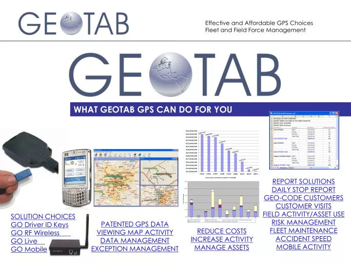
WHAT GEOTAB GPS CAN DO FOR YOU. REPORT SOLUTIONS DAILY STOP REPORT GEO-CODE CUSTOMERS CUSTOMER VISITS FIELD ACTIVITY/ASSET USE RISK MANAGEMENT FLEET MAINTENANCE ACCIDENT SPEED MOBILE ACTIVITY. SOLUTION CHOICES GO Driver ID Keys GO RF Wireless GO Live GO Mobile.

E N D
WHAT GEOTAB GPS CAN DO FOR YOU REPORT SOLUTIONS DAILY STOP REPORT GEO-CODE CUSTOMERS CUSTOMER VISITS FIELD ACTIVITY/ASSET USE RISK MANAGEMENT FLEET MAINTENANCE ACCIDENT SPEED MOBILE ACTIVITY SOLUTION CHOICES GO Driver ID Keys GO RF Wireless GO Live GO Mobile PATENTED GPS DATA VIEWING MAP ACTIVITY DATA MANAGEMENT EXCEPTION MANAGEMENT REDUCE COSTS INCREASE ACTIVITY MANAGE ASSETS
GEOTAB Provides The power of GPS technology to work for businesses is driven from the quality of the data that is collected. How frequently is data logged in memory? What triggers data to be recorded? How soon can I see data in my system? Do I own/store/archive my data behind my security firewall? Is the data useful for fuel savings? Is the data useful for risk management/insurance savings? Is the data useful to improve the productivity of my field force? Is the data available for by other software applications in our company? • As you will see, Geotab provides you with: • a low risk, high return on investment opportunity for your growth, • the highest quality, GPS business data possible, • building block device choices, all database compatible, • affordable, network-safe software options, • reliability from one of the world leading GPS developers of hardware and software business solutions
GEOTAB GPS CHOICES No Monthly Fees Affordable Data Plans GO Key GO RF GO Live GO Mobile ALL GO devices send data to ONE central database on YOUR network! Business Intelligence for SMALL BUSINESS through LARGE FLEET with multiple users report by group, branch, region or division
World leading breadcrumb trail GEOTAB has a patented, world leading method of recording GPS information by logging based on driving behavior (speed, turns, braking, stopping). Unlike competitors that log based on time.
View duplicate miles driven Recording parameters are customizable per vehicle. Multiple vehicle trips can be displayed on a single screen. High or low resolution recording is your choice and will vary depending on your requirements for how vehicles drive (quick stops, city driving, mileage accuracy). The result is trust and reliability in the solution. Geotab delivers on the promise of GPS technology by delivering accurate information.
Trip Recording Flexibility Recording parameters are customizable per vehicle – so high or low resolution recording is your choice and will vary depending on your requirements for how vehicles drive (quick stops, city driving, mileage accuracy).
GEOTAB GPS Building Block System GEOTAB GO Key, GO RF and GO Live systems can grow with you – upgrade firmware and logging frequency wirelessly. Integrate new devices using the Geotab Integration Module. Driver ID keys are optional and capture driver activity when vehicles are rotated regularly. ID keys can also be used for time clock verification. Memory capacity of 15,500 log records Wireless changes to logging parameters and custom firmware 100 Minutes of second-by-second accident data is stored in wraparound memory Reports engine idling (for fuel and maintenance management) An optional vehicle buzzer alerts drivers of speed, seatbelt or other risky driving behavior Up to 4 extra switches can be monitored (seatbelt, doors, motors) Sleep mode allows vehicle to be parked for over 60 days without affecting the battery/vehicle warranty
GO RF NO MONTHLY COST WIRELESS OPTION 900Mhz Digital Spread Spectrum with frequency hopping The vehicle ID is checked in the database to ensure the vehicle is permitted to download at the site 2. If authorized to download, a 2-way wireless download proceeds where the data is sent and verified between vehicle and the receiving base station • 3. Download range is up to 1000 ft. GEOTAB GO RF securely communicates with your network without danger of unauthorized access to your computer network 4. A final signal from the base station confirms that all data was received There is no fleet size restriction in your combining GO systems.
Driver ID Keys Driver ID Keys and Memory Keys are optional and can be interchanged with GO Key, RF and GO Live systems. It’s easy to record driver-specific information. The GEOTAB key is inserted into the Geotab key housing in the vehicle, which logs the key ID. The key is then removed. The driver is now taking responsibility for the trip. If configured to download trip information, the key can be used to extract the trip data from the GEOTAB GO unit. Keys can also be used to recover data from the Geotab accident memory buffer that stores 100 minutes of second-by-second resolution GPS data.
GO Live – GSM/GPRS GEOTAB GO Live securely delivers data to your network without danger of unauthorized access to your computer network. Which vehicles in your fleet NEED to be tracked throughout the day? Our low data use/high resolution recording is second to none – so track your assets for locate and dispatch PLUS drive payback by using Geotab activity, productivity, customer, maintenance and risk management reports. How often do you need to see your data? Pilot with Geotab for low cost/high monthly payback! Many fleets find less than 1MB/vehicle/month of Geotab compressed packet data is all that is sent over the cellular network. Only pay monthly for the data you need sent throughout the day. Easily customize the way you packet and send data to minimize your monthly expense.
GO Mobile Compass and speed are shown on screen. Privacy alert limits tracking to work hours only. Toggle buttons can either be UP/DOWN or a push button to capture incident. Buttons are customized by Mobile Device Group within Checkmate software Message with directions may be sent to the device from the desktop user running Geotab Checkmate Locate your position on a map. Route directions can also be generated using Microsoft MapPoint Web Service
CHECKMATE 5 – ICON LEGEND Icons for driving including exceptions make reconstructing activity simple
VIEW LAST KNOWN POSITION Vehicles last known positions are shown in different colors. Note that their ignition status (ON/OFF) and Auxiliary status are also displayed. Optional driver ID keys will identify driver of the vehicle.
VIEW ASSETS Select to view the last known position and the screen will refresh throughout the day as data is received. This is true for all GO systems! Fleets can combine GO Live, GO Mobile, GO RF and GO Key!
QUICK TRIP VIEW GO RF, GO Live and GO Mobile devices are shown on the single screen. If Driver ID keys are used, trips can be viewed by Drivers. Drill down on date and quickly view exceptions Click on date or exceptions and view on the map
CHECKMATE – Multi-Map Support View multiple maps and zoom levels at the same time! Useful for multi-branches where each branch region can be viewed on a single screen.
GO Mobile – Desktop Feature ON, IN TRAFFIC GO Mobile users indicate field status using toggle buttons - allowing dispatch to send text message and address to the Windows Mobile device.
Improved Mapping Functionality Support for MapPoint and alternative maps (TIGR, ESRI, etc…) Microsoft MapPoint and layered GIS map support – municipal fleets, land developers can view trips on their own GIS maps and when a vehicles leaves their maps –the trip will be displayed on MapPoint Multiple Map Views on a single screen Trip data is updated live throughout the day Zones types (Home, Office and Customer) are colored and labeled
CHECKMATE Data Manager – 4 Sources/1 Database Checkmate’s Server Side Processing method enables large amounts of data to be processed as it is received. When remote site managers request reports or refreshed map views, only a small amount of data needs to be sent over the network. The solution requires little bandwidth and works alongside other network applications. Customers own and store data for maximum data security Live data sent throughout the day via GEOTAB store & forward server to the customer’s database Data from all sources is combined and processed by the Geotab Data Manager for exception rules (speed, stop time, geo-fenced zones (area, customer, home), time of day, and any auxiliary device use GO RF or data key is delivered to the data when vehicles return to the download site
CHECKMATE Data Manager - E-mail Support The Geotab Data Manager can E-mail system support notifications to customer support for proactive maintenance. Pop-up alerts appear on screen notifying activity.
CHECKMATE Data Manager – Proactive Support The new Checkmate Data Manager handles all incoming data as it is received from all Geotab GO units.
CHECKMATE Data Manager – SQL Archive Automatic archiving allows customers to keep data for as long as desired
3 Geo-fence Zone Types GEOTAB Exception Management Tools GEOTAB allows users to customize 3 types of zones. Each zone is displayed in a different color. Area zones are for managing by exception. Quickly report and view driving rules broken (no speeding in side an area, no driving outside an area). Customer zones are for tracking time inside customer zones and for customer visits reporting. Office zones are for tracking asset time back at a depot for asset optimization study of time at depot vs. driving vs. customer time.
Customer Zones Zones can be visible or hidden. Customer zones are for the Checkmate Activity, Trips List and Customer Visits reports and charts. Exception rules can be set up to show vehicles/drivers as they arrive or depart zones after hours or if they stop or speed excessively inside a zone.
Exception Rules Wizard GEOTAB Exception Management Tools Managing by exception allows you to quickly identify activity and operating exceptions. The Exception Wizard helps create rules surrounding speed, stop time, auxiliary use – and then assigns rules to all vehicles or groups or individual vehicles or zones. Exception rules apply 7/24, during work hours only or after hours only. Customer zones are for tracking time inside customer zones and for customer visits reporting. Office zones are for tracking asset time back at a depot for asset optimization study of time at depot vs. driving vs. customer time.
Exception Rules Wizard GEOTAB Exception Management Tools Creating new rules is useful for new data but is also a great analysis tool where rules can be applied to historic data when doing ‘what if’ scenarios.
Exception Management Tools Rules can be applied to vehicle groups – so light duty vehicles can have different rules than heavy duty vehicles.
GEOTAB REPORTS GEOTAB reports are simple to generate within our software application. Each user screen follows a similar one page structure as the Trips List screen shown. Select from GO Devices or Driver Keys. Select the date range, whether you want to display excessive engine idling or over-speeding or any motors, PTOs, seatbelt or other wired sensors. Print or View. The default View is a MS Excel report. If desired, or if Excel is not installed, the report can be generated in html.
Trips List Report GEOTAB REPORTS Trips List – breakdown of the trip including address or customer name of stop, stopped time, the exclusive GEOTAB GPS odometer and idling. Excessive speeding and idling are highlighted in red. Geotab can provide accurate driving miles, driving time and stop time at customer in order to provide route/scheduling variance reporting.
Trips Log Report GEOTAB REPORTS GEOTAB precisely captures latitude/longitude coordinates for customers zones and routing. No driver intervention is required. It’s as simple as driving and turning off the ignition. If ignition is not always turned off, an auxiliary switch or GPS2GO toggle switch can be set to indicate customer site. Generate geo-coded customer locations that are more accurate because they are based on vehicle park location and not address lookup.
Geo-Fencing GPS Data GEOTAB REPORTS The Trips Log Report provides a sequential summary of daily stops with Latitude and Longitude along with the arrival date and stop time. If used with MapPoint, the report provides an address lookup feature to assist in identifying the customer. This report can be used to auto-create customer zones within GEOTAB software for Customer Visits Reports. Use with the Checkmate Import Customer Wizard tool.
Fleet Maintenance GEOTAB REPORTS GEOTAB is the ONLY GPS system to offer: Distance, Maintenance, Lease Expiry, Monthly Lease Mileage quota data WITHOUT having drivers record odometer readings or tapping into the engine. If engine information is desired (fault codes, odometer), then an expansion module is available.
Risk Management Report GEOTAB REPORTS When Driver ID system deployed – track by driver-specific behavior regardless of which vehicle is driven, otherwise, vehicle only behavior is monitored. Speed > keep drivers below 70mph – accidents involving speed greater than 70mph sustain significantly higher personal injury to drivers. This summary data used to implement Driver Safety Scorecard system. Stop Lengths > excessive stop times can represent lower productivity but also higher risk for cargo theft Idling > a vehicle left idling is at higher risk of theft (not to mention wasted fuel, greenhouse gas emissions and increased engine wear) After Hours Trips > monitor if DUI is a problem due to after hours trips Harsh Braking > displayed on the Exception Summary report but can be added to standard Risk Management Report
Risk Management Report The quality of Geotab GPS empowers fleets with the tools to take action to reduce insured or self-insured claims.
Customer Visits Report GEOTAB REPORTS –ACCOUNT FOR CUSTOMER TIME/GROW SALES Customer Visits can be broken down by vehicle or driver (ID keys with GO RF or GO Live required. This report shows all stops at a customer in April -05 allowing 1) proof of activity, 2) evaluation of value of time spent, and 3) study of profitability of the account based on time to service.
Customer Visits Chart Quickly chart time at customers and identify who your company is investing your field time with. Compare with profitability to see if that time is spent wisely.
Activity Chart GEOTAB REPORTS The Activity Report is the first step in a ‘QUICK START’ analysis of how often assets are used, customers visited and vehicles driven. The report provides needed perspective for managers to reassess how field personnel and assets are deployed.
Activity Report The MS Excel report can be sorted by any column. Speeding is included in this report because we want to ensure that as drivers increase productivity, that they are not compromising safety in speeding.
GPS2GO Activity Report GEOTAB REPORTS – ACTIVITY SUMMARY FOR GO MOBILE USERS All Geotab reports are generated in MS Excel. The GPS2GO Activity Report shown summarizes the use of the touch screen buttons on the mobile device. A detailed summary is also easily generated. All Geotab reports are provided in MS Excel for further use and analysis.
Auxiliary Sensor Report GEOTAB REPORTS Auxiliary Report - Easily monitor and report unauthorized use of any wired devices such as seat belts or cargo doors. The settings on this screen would detect if the sensor (wired to Aux1) is ON for a period of longer than 10 minutes while the engine is left running on the vehicle. The street address or work zone name of where the exception happened will be displayed on the final report. The settings allow easy user configuration of Auxiliary use rules. The report forms the basis of a need for driver training, customer invoicing or proof of activity.
Speed Profile Report GEOTAB REPORTS Speed Profile Report – use with Geotab’s 100 minute accident data recorded in separate memory buffer on the vehicle unit Should an accident occur or the GEOTAB exception processor detect harsh braking or speeding incidents, then a Speed Profile Report is a useful tool to view driving habits during the day. The report is used together with GEOTAB’s 100 minutes of second-by-second GPS data accident reconstruction data that is stored in a unique memory buffer on board the GEOTAB black box.
CUSTOM ENGINEERED SOLUTIONS Geotab base recording systems have expansion capability to integrate with devices such as bar code wand scanners, or engine diagnostics connectors. CHECKMATE software is written with open architecture for integration with third party software programs in administration and maintenance. For example, GEOTAB has written a custom user interface that displays Symbol Handheld data on the Checkmate View Trip screen. Contact GEOTAB to discuss your custom engineered solution requirement.
WHAT MAKES GEOTAB UNIQUE? GEOTAB is a LOW RISK / HIGH Return On Investment Solution • ONE application, MANY solutions: • AVL/Field Force Location • World-leading breadcrumb trip view • Time Activity Management • Asset Use Management • Risk Management • Lease Management • Fleet Maintenance • Fuel conservation • Fuel Tax Management • Engine Idling Reduction • Customer Time Analysis • Fleet Size Management • Exception Reporting • Route Auditing • Device and software integration Industry-leading, patented GPS recording system for trip and event recordingSimple to use and learn software – initial training to field branch managers in half dayEnterprise Solution for network deployments – with password authorized access for Division, Region, Branch and National Managers. MORE GROWTH CHOICES – MORE VALUE – HIGH QUALITY – SOLUTIONS DRIVEN
Affordable Monthly solutions No Monthly Fees GO Key GO RF GO Live GO Mobile GEOTAB GPS CHOICES ALL GO devices send data to ONE central database on YOUR network! Business Intelligence for SMALL BUSINESS through LARGE FLEET with multiple users report by group, branch, region or division
CONTACT US To discuss your needs or to arrange an on-site meeting or trial with one of our representatives: Email: sebastien@aalto.net Call: 1-877-68AALTO Web: www.aalto.net