Download
1 / 1
10 likes | 173 Vues
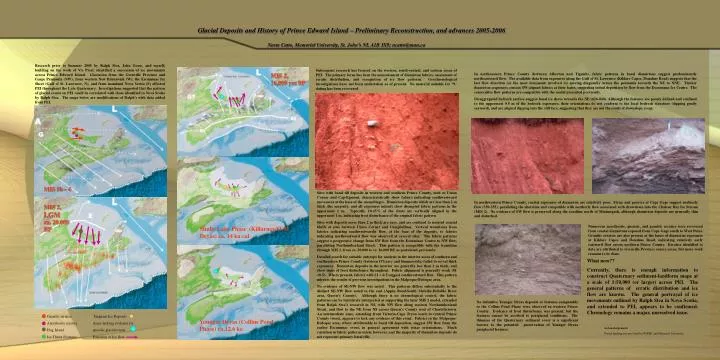
MIS 2, 16,000 yrs BP. MIS 2, LGM ca. 20,000 BP. Younger Dryas (Collins Pond Phase) ca.12.6 ka. Shulie Lake Phase (Killarney/O-M Dryas) ca. 14 ka cal. MIS 5b - 4. Glacial Deposits and History of Prince Edward Island – Preliminary Reconstruction, and advances 2005-2006.

E N D
MIS 2, 16,000 yrs BP MIS 2, LGM ca. 20,000 BP Younger Dryas (Collins Pond Phase) ca.12.6 ka Shulie Lake Phase (Killarney/O-M Dryas) ca. 14 ka cal MIS 5b - 4 Glacial Deposits and History of Prince Edward Island – Preliminary Reconstruction, and advances 2005-2006 Norm Catto, Memorial University, St. John’s NL A1B 3X9; ncatto@mun.ca Research prior to Summer 2005 by Ralph Stea, John Gosse, and myself, building on the work of Vic Prest, identified a succession of ice movements across Prince Edward Island. Glaciation from the Grenville Province and Gaspe Peninsula (NW); from western New Brunswick (W); the Escuminac Ice Sheet (Gulf of St. Lawrence, N), and from mainland Nova Scotia (S) affected PEI throughout the Late Quaternary. Investigations suggested that the pattern of glacial events on PEI could be correlated with those identified in Nova Scotia by Ralph Stea. The maps below are modifications of Ralph’s with data added from PEI. Subsequent research has focused on the western, south-central, and eastern areas of PEI. The primary focus has been the measurement of diamicton fabrics, assessment of erratic distribution, and recognition of ice flow patterns. Geochronological investigations have not been undertaken as of present. No material suitable for 14C dating has been recovered. In northeastern Prince County (between Alberton and Tignish), fabric patterns in basal diamictons suggest predominantly northeastward flow. The available data from exposures along the Gulf of St. Lawrence (Kildare Capes, Donahue Road) suggests that the last flow direction (or the most dominant) involved ice moving diagonally across the peninsula towards the NE to NNE. Thicker diamicton sequences contain SW-aligned fabrics at their bases, suggesting initial deposition by flow from the Escuminac Ice Centre. The consecutive flow patterns are compatible with the model presented previously. Disaggregated bedrock surface suggest basal ice shove towards the NE (026-040). Although the features are poorly defined and confined to the uppermost 0.5 m of the bedrock exposures, their orientations do not conform to the local bedrock structure (dipping gently seaward), and are aligned dipping into the cliff face, suggesting that they are not the result of downslope creep. Sites with basal till deposits in western and southern Prince County, such as Union Corner and Cap-Egmont, characteristically show fabrics indicating southwestward movement at the base of the assemblages. Diamicton deposits which are less than 2 m thick (the majority, and all exposures inland) show disrupted fabric patterns in the uppermost 1 m. Typically, 10-15% of the clasts are vertically aligned in the uppermost 1 m, indicating frost disturbance of the original fabric pattern. Sites with deposits more than 2 m thick are rare, and are confined to isolated coastal bluffs at sites between Union Corner and Campbellton. Vertical transitions from fabrics indicating southwestwardly flow, at the base of the deposits, to fabrics indicating northwestward flow was observed at several sites. The fabric patterns suggest a progressive change from SW flow from the Escuminac Centre to NW flow, paralleling Northumberland Strait. This pattern is compatible with the transition through MIS 2, from ca. 20,000 to ca. 16,000 BP, as postulated previously. Detailed search for suitable outcrops for analysis in the interior areas of southern and southeastern Prince County (between O’Leary and Summerside) failed to reveal thick exposures. Diamicton deposits in the interior are generally less than 2 m thick, and show signs of frost disturbance throughout. Fabric alignment is generally weak (S1 <0.5). Where present, fabrics with S1 > 0.5 suggest southwestward flow. This pattern mirrors the results of previous investigations in the Malpeque-Bedeque area. No evidence of SE-NW flow was noted. This patterns differs substantially to the distinct SE-NW flow noted to the east (Appin Road-South Melville-DeSable River area, Queen’s County). Although there is no chronological control, the fabric patterns can be tentatively interpreted as supporting the later MIS 2 model, extended from Ralph Stea’s research in NS, with NW flow along western Northumberland Strait, and flow to the NE from NS across Queen’s County west of Charlottetown. An intermediate zone, extending from Victoria-Cape Tryon (east) to central Prince County (west), appears to lack any evidence of this event. Fabrics in the Malpeque-Bedeque area, where attributable to basal till deposition, suggest SW flow from the earlier Escuminac event, in general agreement with striae orientations. Much variation in fabric patterns exists, however, and the majority of diamicton deposits do not represent primary basal tills. In northwestern Prince County, coastal exposures of diamicton are relatively poor. Striae and grooves at Cape Gage suggest northerly flow (350-355), paralleling the shoreline and compatible with northerly flow associated with drawdown into the Chaleur Bay Ice Stream (MIS 2). No evidence of SW flow is preserved along the coastline north of Minimegash, although diamicton deposits are generally thin and disturbed. Numerous anorthosite, gneissic, and granitic erratics were recovered from coastal diamictons exposed from Cape Gage south to West Point. Granitic erratics are also present at the bases of diamicton exposures at Kildare Capes and Donahue Road, indicating relatively early eastward flow across northern Prince County. Erratics identified to date are attributed to Grenville Province source areas, but more work remains to be done. What now?? Currently, there is enough information to construct Quaternary sediment-landform maps at a scale of 1:50,000 (or larger) across PEI. The general patterns of erratic distribution and ice flow are known. The general portrayal of ice movements outlined by Ralph Stea in Nova Scotia, and extended to PEI, appears to be confirmed. Chronology remains a major, unresolved issue. No definitive Younger Dryas deposits or features comparable to the Collins Pond Phase were observed in western Prince County. Evidence of frost disturbance was present, but the features cannot be ascribed to periglacial conditions. The thinness of the Quaternary sediment cover is a significant barrier to the potential preservation of Younger Dryas periglacial features. Granitic erratics Stagnant Ice Deposits Anorthosite erratics Areas lacking evidence for Hog Island specific glacial event Ice Thrust Features Direction of Ice flow Acknowledgements Partial funding was provided by NSERC and Memorial University.