Download
1 / 17
170 likes | 251 Vues
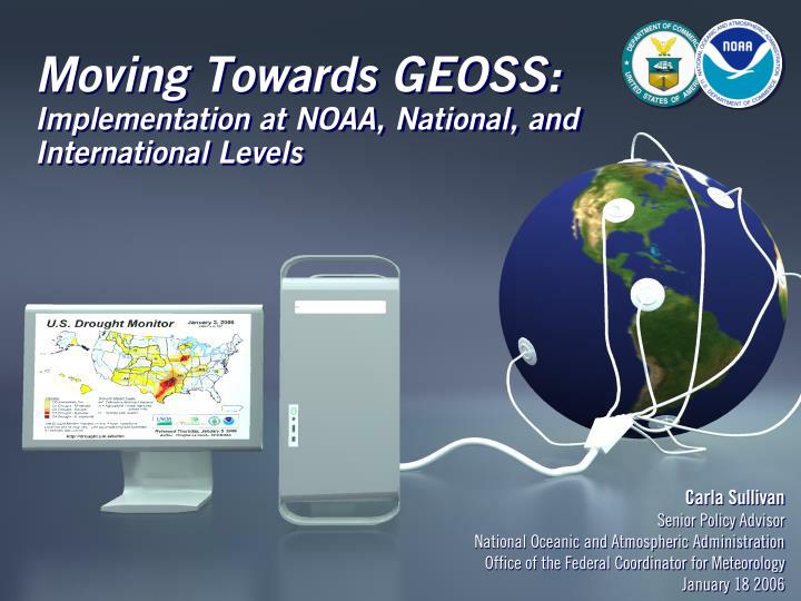
Moving Towards GEOSS: Implementation at NOAA, National, and International Levels. Carla Sullivan Senior Policy Advisor National Oceanic and Atmospheric Administration Office of the Federal Coordinator for Meteorology January 18 2006.

E N D
Moving Towards GEOSS: Implementation at NOAA, National, and International Levels Carla Sullivan Senior Policy Advisor National Oceanic and Atmospheric Administration Office of the Federal Coordinator for Meteorology January 18 2006
Global Earth Observation System of SystemsIntegrated Observations & Data Management Moving Towards GEOSS
GEO Moves Forward:Working Towards Implementation • Adopted formal GEO organization and 10-year implementation plan • Held GEO I in May 2005, and GEO II in December 2005 • Selected new GEO Secretariat Director, Jose Achache • Accepted 2006 Work Plan, adopted a budget and formally created GEO Committees • Architecture and Data; Capacity Building; Science and Technology; User Interface; and Working Group on Tsunami Activities Moving Towards GEOSS
GEO Moves Forward:Working Towards Implementation • Near-Term Implementation Efforts: • Working Group on Tsunami Activities continuing to provide integration observation requirements to the Indian Ocean Tsunami Early Warning System effort • United States announced intention to move GOES satellite to a position to help offset the lack of sounder data over South America • GEO-Netcast proposed as tangible near term project to implement GEOSS Moving Towards GEOSS
USGEO Near-Term Opportunities • US Strategic Plan provides the framework for the US contribution to GEO USGEO tracking US activities to GEO WorkPlan • USGEO focusing on 6 Near-Term Opportunities • Disasters • Drought / National Integrated Drought Information System • Land Observation • Air Quality • Sea Level • Data Management Moving Towards GEOSS
USGEO Near Term Opportunity (NTO) Plans • Plans due to OSTP/OMB in early 2006, as part of subcommittee’s annual reporting requirement • Plans to be used for agency planning, as well as for inclusion in OSTP/OMB’s annual federal research and development guidance • Plans look at observation investments in 2005 enacted, as well as 2006 requested budgets • Plans further identify gaps in coverage and potential low-cost / high impact remedies for those gaps Moving Towards GEOSS
NTO - Disasters • Identifies need for integrated, end-to-end, disaster reduction framework, and explores multi-hazard demonstration projects for two regions at high risk: the Pacific states and the Gulf of Mexico coast • Projects would deliver the following products and services: • Real-time earthquake information delivery for targeting rapid emergency response • Improved tsunami and coastal inundation forecast and warning capability • Rapid detection of conditions allowing forecasting of volcanic eruptions, especially ash-forming events endangering aviation • Prototype early warning system for debris flows and landslides in wildfire-impacted areas • Tracks to GEOSS and IEOS benefit areas: • Disasters Moving Towards GEOSS
NTO - National Integrated Drought Information System (NIDIS) • Identifies critical gaps in the nation’s infrastructure, which inhibit our ability to most effectively reduce the impact of drought • Early opportunities to address gaps include: • Improvements in the frequency, timeliness, and density of key observations • Creation of an Internet portal to provide a drought early warning system • Establishment of a NIDIS operations office to ensure optimization of existing Federal, state, local and private sector observations and information delivery • Tracks to GEOSS and IEOS benefit areas • Water Resource Management • Disasters • Sustainable Agriculture • Climate Variability and Change Moving Towards GEOSS
NTO – Land Observing • Identifies three enhancements that would be the basis of a functional GLOS: • Mid-decadal global data set of high resolution (30m) satellite imagery in 2006 • Global land data base at high resolution (30m) and the seasonal collection of such data (i.e., continuity of Landsat-type observations) • Extension of a network (Global Integrated Trends Analysis Network) that combines ground data and earth observations from aircraft and space to evaluate land cover trends • Tracks to GEOSS and IEOS benefit areas: • Terrestrial Ecosystems • Climate Variability and Change • Disasters • Biodiversity • Sustainable Agriculture/Combating Desertification Moving Towards GEOSS
NTO – Air Quality • Noting that more than one-third of the U.S. population lives in areas that have unhealthy air quality (AQ), causing an estimated tens of thousands of deaths and costing society more than $100B, this plan identifiesneed for: • Integrated Observation-Model Air Quality Fields • Systems for Utilizing Observations to Improve AQ Forecasts • Assessments of Key Air Quality Processes • Improved Emissions Inventories • Improved International Transport Assessments • Tracks to GEOSS and IEOS benefit areas: • Human Health • Weather Forecasting • Climate Variability and Change Moving Towards GEOSS
NTO – Sea Level • Identifies needs for direct ocean observations, coastal Observations, ice sheet measurements and associated observations, and reference frames • Major recommendations include: • Explore options for operationalizing satellite altimetry data sets • Initiate planning for potential ICESat follow-on at NASA • Tracks to GEOSS and IEOS benefit areas: • Marine/Coastal Ecosystems (GEO) / Oceans (USGEO) • Climate Variability and Change • Disasters Moving Towards GEOSS
NTO – Data Management • Identifies goal to provide specific crosscutting or interagency integration of data management infrastructure or tools to assist the development of the other five IEOS NTOs • Specific architecture and data management objectives include: • Data Portals • Improved Infrastructure and Resources • Better Interoperability • Improved Metadata • Consistent Terminology • Clearinghouse • Consistent Data Policy • Tracks to GEOSS and IEOS benefit areas: • Crosscuts all benefit areas Moving Towards GEOSS
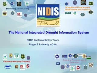
GEOSS USGEO IOOS ISOS IUOS HCN COOP-M ASOS CRN LegacyCOOP Other Networks NERON NOAA’s Integrated Surface Observing System Moving Towards GEOSS
NOAA’s Integrated Surface Observing System NERON Moving Towards GEOSS
NOAA’s Integrated Surface Observing System • Climate Reference Network • Accuracy: Very High • Redundancy: Yes • Siting: Climate Quality • Data Timeliness: Hourly • Fields: Temperature, Precipitation, Wind Speed/Direction, Surface IR, Relative Humidity, Total Solar Radiation • Modernized Historical Climate Network (NERON) • Accuracy: High • Redundancy: Some sensors • Siting: Climate Quality • Data Frequency: Hourly • Fields: Initially Temperature, Precipitation • Modernized COOP (NERON) • Accuracy: High • Redundancy: No • Siting: Climate and Societally relevant • Data Frequency: Minutes • Fields: Initially Temperature, Precipitation Moving Towards GEOSS
NOAA’s Integrated Surface Observing System • Legacy COOP (NERON) • Accuracy: Variable • Redundancy: No • Siting: Variable • Data Frequency: Variable • Fields: Temperature, Precipitation, Snow, • ASOS (NERON) • Accuracy: High • Redundancy: No • Siting: Airport Operations • Data Frequency: Minutes • Fields: Temperature, Precipitation, Visibility, Ceiling, Relative Humidity, Wind Speed/Direction, • Other Networks (NERON) • Accuracy: Variable • Redundancy: No • Siting: Variable • Data Frequency: Variable • Fields: Variable Moving Towards GEOSS
Resulting Capacity • Integrated System of Systems • Expanded Data Sets • Spectrum of Quality • Spectrum of Timeliness • Spectrum of Parameters • Spectrum of Scales • Expanded Services • NIDIS • Nowcasting • Climate Benchmarking – long-term continuity • Expanded Partnerships Moving Towards GEOSS