Download
1 / 58
600 likes | 669 Vues
Radio Navigation. HDG 105° DME20 ALT = 5000ft Radial 140 Incercept: 345° CRS TO Do I turn left or right? Do I fly heading 315° or 015°?. Effective use of NAV instruments. Radio Navigation. For a successful navigation we need to: Understand how to use a map

E N D
HDG 105° DME20 ALT = 5000ft Radial 140 Incercept: 345° CRS TO Do I turn left or right? Do I fly heading 315° or 015°? Effective use of NAV instruments
Radio Navigation For a successful navigation we need to: Understand how to use a map Understand the function of an OBI/RMI Understand the terminology Only after we can be fully able to navigate
Basic Rule for navigation • Consider the compass instrument as a map. • (needle) arrow ALWAYS FALL (RMI). • (needle) tail ALWAYS RISE (RMI). • The station is ALWAYS IN THE CENTER. • The aircraft is ALWAYS ON THE TAIL.
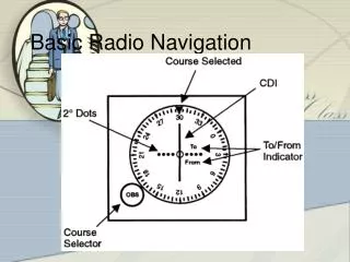
Omni Bearing Indicator Basic Rule for navigation
Omni Bearing Indicator Let’s remove numbers for the purpose of exercise Using OBI for navigation
I cannot determine accurate position whitout centering Accurate position is needed to carry out accurate navigation Using OBI for navigation
Step 1: center the instrument. It is not important if it falls To or From Using OBI for navigation
Where is the station? Using OBI for navigation
Where is the station? Always in the center of the instrument! Using OBI for navigation
Where is the aircraft? Using OBI for navigation
Where is the aircraft? Always on the tail of the needle! Which one is the tail? Using OBI for navigation
Where is the aircraft? Always on the tail of the needle! Look at the pointer TO/FROM Using OBI for navigation
I have no indication about the heading of the aircraft. Which radial do I want to intercept? Using OBI for navigation
Find the route I want to follow Using OBI for navigation
Find the route I want to follow Using OBI for navigation
bring selected route parallel from the center of the instrument, and find the desired heading Using OBI for navigation
Now start turning onto the new heading frist. Then move the OBS to select desired radial. Using OBI for navigation
Radio Magnetic Indicator Using RMI for navigation
Radio Magnetic Indicator Let’s remove numbers for the purpose of exercise Using RMI for navigation
Where is the station? Using RMI for navigation
Where is the aircraft? Using RMI for navigation
The heading of the aircraft is always upward. Now find the radial to intercept. Using RMI for navigation
Visualise the range of possible headings to intercept as desired Using RMI for navigation
Note that in this example a 90° intercept would bring us intercepting the reciprocal radial. If radial has to be inbound, leave adequate turn distance Using RMI for navigation
Once selected a heading turn onto that heading, the RMI allow monitoring of intercept progress Using RMI for navigation
Coming back on numbers, let’s monitor this intercept I turn 45° on the left, new heading 325° Using RMI for navigation
Coming back to basic rules: Arrows always falls, Tails always rise. Will the needle move toward the blue cross? Using RMI for navigation
Yes, the aircraft is leaving the station behind on the left wing: Arrows always falls, Tails always rise. Using RMI for navigation
To intercept the radial inbound, shall I turn left or right? Using RMI for navigation
I read DME20, and wish to intercept radial 220 at DME 10 From such point I will join a left DME10 arc until radial 090 Can you see the intended track? Advanced Use of RMI
Draw distance circles, my aircraft is at 20DME. Advanced Use of RMI
Draw distance circles, my aircraft is at 20DME. Find desired Radial Advanced Use of RMI
Draw distance circles, my aircraft is at 20DME. Find desired Radial Find desired DME Advanced Use of RMI
Find desired heading to reach the point and see the subsequent turn and arc. Advanced Use of RMI
Find desired heading to reach the point and see the subsequent turn and arc. Advanced Use of RMI
Flying DME arcs. • The direction of the arc as left or right is referred to the direction of turns once established in the arc.
Flying DME arcs. • The direction of initial turn depend from the inbound/outbound arrival. • The arc is flown as straight segments of approximately 10 degrees
Advanced Use of RMI • Enter the 10NM Arc to the left. • Actual DME read 20NM
Advanced Use of RMI • Proceed inbound the station until DME reads 10 plus leading distance. • Make short legs of 10 degrees.