Download
1 / 21
210 likes | 295 Vues
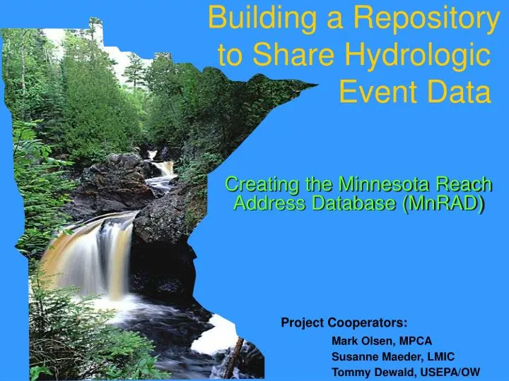
Building a Repository to Share Hydrologic Event Data. Creating the Minnesota Reach Address Database (MnRAD). Project Cooperators: Mark Olsen, MPCA Susanne Maeder, LMIC Tommy Dewald, USEPA/OW. Minnesota Water Quality Business Needs.

E N D
Building a Repository to Share Hydrologic Event Data Creating the Minnesota Reach Address Database (MnRAD) Project Cooperators: Mark Olsen, MPCA Susanne Maeder, LMIC Tommy Dewald, USEPA/OW
Minnesota Water Quality Business Needs • Integrate water related information from different sources • Electronic data access and exchange
Minnesota Water Quality Challenges • Distributed authority • Requires cooperation • Need to integrate and exchange data • Legacy data • Standards: codified and defacto • Data inconsistencies
Key Components • Standards Based Approach for Critical Infrastructure • STORET/Assessment Database (ADB) • Environmental Data Access (EDA) • Public and timely access • Better use of local data • Competent repository • National Hydrography Dataset (NHD) • Exchange Network • MnRAD
Key Components - NHD • Formal coordination mechanism • Governor’s Council • Local buy-in • Use of value added data • Cross reference to existing systems • Involvement in production process • Partnerships • Fund match • Expertise • Tools and data • Outreach • Education and training • Reach Indexing Tool (RIT) • NHD data and use
NHD is the Framework for Integration • NHD Consists of: • Hydrographic features for making maps • A national stream addressing system • A modeling network for navigating upstream/downstream • A maintenance infrastructure
What are NHD Reaches? Watershed 02050701 Watershed 02050701 contains 3 NHD reaches: - 02050701000001 - 02050701000002 - 02050701000003 which provide the framework for stream (reach) addresses in the same manner that streets do for street addresses 2 1 3
Water Quality Standards Nonpoint Source Grants National Hydrography Dataset Water Quality Monitoring Impaired Waters & Total Maximum Daily Loads EPA/OW WATERS Data Architecture (Watershed Assessment, Tracking & Environmental ResultS) (www.epa.gov/waters) WQSDB GRTS Reach Address Database (RAD) STORET NTTS ADB/NAD Water Quality Assessments
MnRAD Goals Business need: Integrate water data from different sources • MnRAD as central repository • Authoritative source of NHD • Manage and share data and related events • Locally update and maintain NHD • Consistent with national repository
MnRAD Goals Business need: Electronic data access and exchange • Enable electronic exchange of water quality data with EPA • Programmatic data • Assessed and impaired waters (305(b)/303(d) ) • Geospatial data • NHD events relating to that reporting
MnRAD Progress Through Partnerships • Critical success factors: • Cooperative agreement with EPA Office of Water • RAD design and expertise • Integrated reporting process improvements • Exchange Network • EPA systems and tools • Reach Indexing Tool (RIT) • Assessment Database (ADB) • STORET • USGS tools for state stewardship
MnRAD Accomplishments • Assess user needs • Establish new WQ reporting data and process flows with EPA • Programmatic and geospatial • NHD • transition to Geodatabase • 100K to 24K migration • Update and maintenance
NHD Stewardship and Updates • Nationwide database at USGS • Local updates to USGS • “Administrative” steward in state • State authoritative copy • Gatekeeper for the state’s updates • Many potential updaters/ coordinate and track updates • USGS synchronizes updates back to states
MnRAD Accomplishments • Assess user needs • Establish new WQ reporting data and process flows with EPA • Programmatic and geospatial • NHD • transition to Geodatabase • 100K to 24K migration • Update and maintenance • Draft system design
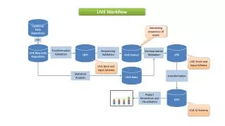
MnRAD CDX Spatial Data Submission: Part 1: Minnesota Data Submittal
MnRAD CDX Spatial Data Submission: Part 2: CDX Web Services
MnRAD CDX Spatial Data Submission: Part 3: Backend Handoff
MnRAD Next Steps • Complete system design and implement • Finalize flow configuration document for integrated reporting • Develop system and methods to update the NHD for Minnesota
For More Information • Mark Olsen: 651-296-3412 mark.olsen@pca.state.mn.us • Susanne Maeder: 651-201-2488 susanne.maeder@state.mn.us