Download
1 / 35
350 likes | 460 Vues
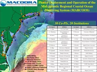
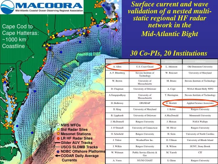
Surface current and wave validation of a nested multi-static regional HF radar network in the Mid-Atlantic Bight. NWS WFOs Std Radar Sites Mesonet Stations LR HF Radar Sites Glider AUV Tracks USCG SLDMB Tracks NDBC Offshore Platforms CODAR Daily Average Currents. Cape Cod to

E N D
Surface current and wave validation of a nested multi-static regional HF radar network in the Mid-Atlantic Bight NWS WFOs Std Radar Sites Mesonet Stations LR HF Radar Sites Glider AUV Tracks USCG SLDMB Tracks NDBC Offshore Platforms CODAR Daily Average Currents Cape Cod to Cape Hatteras: ~1000 km Coastline 30 Co-PIs, 20 Institutions
Regional Theme 1: Maritime Safety – Search And Rescue MARCOOS Regional Observations Before HF Radar Coast Guard SAROPS After HF Radar USCG Weatherflow
Search & Rescue Problem • Create a SAR case when alerted
Search & Rescue Problem • Create a SAR case when alerted • Gather information about case
Search & Rescue Problem • Create a SAR case when alerted • Gather information about case • Get environmental data & uncertainties
Search & Rescue Problem • Create a SAR case when alerted • Gather information about case • Get environmental data & uncertainties • Use model to determine search area
Search & Rescue Problem • Create a SAR case when alerted • Gather information about case • Get environmental data & uncertainties • Use model to determine search area • Estimate resource availability and capability
Search & Rescue Problem • Create a SAR case when alerted • Gather information about case • Get environmental data & uncertainties • Use model to determine search area • Estimate resource availability and capability • Plan, promulgate & perform the next search
Search & Rescue Problem • Create a SAR case when alerted • Gather information about case • Get environmental data & uncertainties • Use model to determine search area • Estimate resource availability and capability • Plan, promulgate & perform the next search • Evaluate the completed search
Search & Rescue Problem • Create a SAR case when alerted • Gather information about case • Get environmental data & uncertainties • Use model to determine search area • Estimate resource availability and capability • Plan, promulgate & perform the next search • Evaluate the completed search • Repeat above until survivors are found and rescued
Catalog Server Winds Currents Drifters Weather THREDDS OPeNDAP EDS Catalog DB Web Services Internet SAROPS Client Web Client
Example EDS Data Sources • Winds • FNMOC NOGAPS • FNMOC COAMPS • NOAA NCEP NAM • NOAA NCEP GFS • NOAA NDFD* • NOAA NDBC • Regional Models (e.g GLERL) • Other… commercial • Currents • NAVO Global NCOM • NOAA NCEP HYCOM • NOS Regional • ADCIRC • CODAR • Regional Models • Other… Bluelink, • Satellite Data(AOML), commercial
Example EDS Data Sources • Winds • FNMOC NOGAPS • FNMOC COAMPS • NOAA NCEP NAM • NOAA NCEP GFS • NOAA NDFD* • NOAA NDBC • Regional Models (e.g GLERL) • Other… commercial • Currents • NAVO Global NCOM • NOAA NCEP HYCOM • NOS Regional • ADCIRC • CODAR • Regional Models • Other… Bluelink, • Satellite Data(AOML), commercial
Regional Theme 1: Maritime Safety Search And Rescue Product Flow Chart MARCOOS QA/QC HF Radar Data STPS, (UConn) SAROPS ROMS (Rutgers) YEAR 1 HOPS (SMAST) YEAR 2 NYHOPS (Stevens)
US Coast Guard SAROPS Testbed Models SAROPS QA/QC Goals: Ensure that data going to Coast Guard is within uncertainty estimates defined in SAROPS Standardize settings among 26 current sites. Continue research on new algorithms/settings
US Coast Guard SAROPS Testbed July 26-September 15 2006 10 Drifters 51 Days February 24 – April 7 2007 2 Drifters 45 Days In Partnership with - USCG R&D Center - USCG Office of SAR - URI (Dave Ullman)
HF radar grid HF radar grid Tuckerton
Abs[Codar-drifter] (cm/s) RMS: 10.24 cm/s R2: 0.62
Total Vector Comparisons East Component RMS: 8.5 cm/s R2: 0.76 NP: 929 North Component RMS: 11.7 cm/s R2: 0.40 NP: 929
Test and Evaluate QA/QC Procedures UNC-CH (Seim and Haines) - First Order Lines - MUSIC Parameters ODU (Garner and Atkinson) - Real-time Diagnostics - Baseline Comparisons Rutgers (Kohut, Roarty, Lichtenwalner) - Merging Algorithm - Antenna Pattern Sensitivity - Nearshore waves and Currents
Test and Evaluate QA/QC Procedures UNC-CH (Seim and Haines) - First Order Lines - MUSIC Parameters ODU (Garner and Atkinson) - Real-time Diagnostics - Baseline Comparisons Rutgers (Kohut, Roarty, Lichtenwalner) - Merging Algorithm - Antenna Pattern Sensitivity - Nearshore waves and Currents
How CODAR Averages… Time Series Cross-spectra Radial Files 11:00 12:00 13:00 RadsSITE_04_04_21_1200
Test and Evaluate QA/QC Procedures Original Algorithm RMS: 11.7 cm/s R2: 0.55 NP: 783 Vector Count Min: 2 Max: 4 Avg: 2.8 New Algorithm RMS: 10.8 cm/s R2: 0.60 NP: 842 Vector Count Min: 3 Max: 12 Avg: 6.8
Test and Evaluate QA/QC Procedures UNC-CH (Seim and Haines) - First Order Lines - MUSIC Parameters ODU (Garner and Atkinson) - Real-time Diagnostics - Baseline Comparisons Rutgers (Kohut, Roarty, Lichtenwalner) - Merging Algorithm - Antenna Pattern Sensitivity - Nearshore waves and Currents
HF Radar derived Wave Evaluation Longterm trends and focused process studies
Transition Through the Storm
Present Algorithm HF Radar derived Wave Evaluation Nearshore bathymetric effects Inversion: deep to shallow (Lipa and Barrick) Linear dispersion vs. depth Refraction: Snell’s Law CODAR In Situ Nearshore Algorithm
Test and Evaluate QA/QC Procedures UNC-CH (Seim and Haines) - First Order Lines - MUSIC Parameters ODU (Garner and Atkinson) - Real-time Diagnostics - Baseline Comparisons Rutgers (Kohut, Roarty, Lichtenwalner) - Merging Algorithm - Antenna Pattern Sensitivity - Nearshore waves and Currents December 2007 – February 2008
Summary MARCOOS is providing regional surface current observations to the Coast Guard through SAROPS MARCOOS will provide regional surface current forecasts to the Coast Guard through SAROPS MARCOOS QA/QC team is continually testing new algorithms to further lower uncertainties of surface current and nearshore wave estimates.