Download
1 / 29
340 likes | 585 Vues
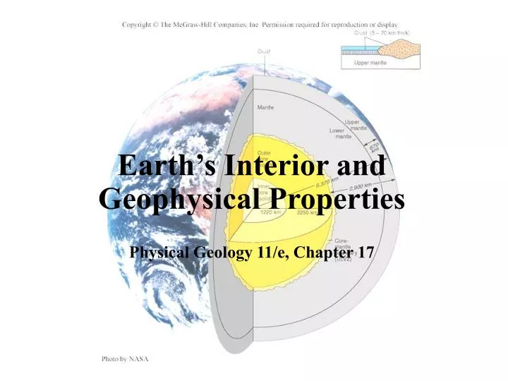
Earth’s Interior and Geophysical Properties Physical Geology 11/e, Chapter 17. Introduction. Geophysics is the branch of geology that studies the interior of the Earth Deep interior of the Earth must be studied indirectly Deepest drillhole was about 12 km, but did not reach the mantle.

E N D
Earth’s Interior and Geophysical PropertiesPhysical Geology 11/e, Chapter 17
Introduction • Geophysics is the branch of geology that studies the interior of the Earth • Deep interior of the Earth must be studied indirectly • Deepest drillhole was about 12 km, but did not reach the mantle
Introduction • Direct access only to crustal rocks and small upper mantle fragments brought up by volcanic eruptions or accreted onto continents by subducting oceanic plates
Evidence from Seismic Waves • Seismic waves or vibrations from a large earthquake (or underground nuclear test) will pass through the entire Earth • Affected by the properties of Earth materials, • Density and state (solid or liquid) may result in changes in seismic wave velocity, reflection, refraction, or both reflection and refraction. • Allow geologists to ‘see’ into the Earth
Evidence from Seismic Waves • Seismic reflection - the return of some waves to the surface after bouncing off a rock layer boundary • Sharp boundary between two materials of different densities will reflect waves
Evidence from Seismic Waves • Seismic refraction - bending of seismic waves as they pass from one material to another with different seismic velocities • V2 > V1 = ‘upward’ refraction • V2 < V1 = ‘downward’ refraction • Seismic velocity (and density) of the mantle increases uniformly with depth • Curved ray paths result because the wavefronts are continuously refracted
Earth’s Internal Structure • The crust, mantle and core, the three main layers within the Earth, have been determined based on seismic evidence.
The Crust • The crust is the outer layer of rock that forms a thin skin on Earth’s surface • Seismic wave studies indicate that the crust is thinner and denser beneath the oceans than on the continents
The Crust • Seismic wave velocities are different in oceanic (7 km/sec) vs. continental (~6 km/sec) crustal rocks • Indicate different compositions • Oceanic crust is mafic • Primarily of basalt and gabbro (basaltic and gabbroic) • Continental crust is felsic • Average composition is similar to granite and rhyolite (granitic and rhyolitic)
Crust-Mantle Boundary • The crust-mantle boundary, called the Mohorovičić discontinuity or Moho,is marked by a jump in seismic wave velocity.
The Mantle • The mantle is a thick shell of dense rock that separates the crust above from the core below • Seismic wave studies indicate the mantle, like the crust, is made of solid rock with only isolated pockets of magma • Higher seismic wave velocity (8 km/sec) of mantle vs. crustal rocks indicate denser, ultramafic composition
The Mantle • Crust + upper mantle = lithosphere, the brittle outer shell of the Earth that makes up the tectonic plates • Lithosphere averages 70 km thick beneath oceans and 125-250 km thick beneath continents • Beneath the lithosphere, seismic wave speeds abruptly decrease in a plastic low-velocity zone called the asthenosphere
The Core-Mantle Boundary • Core-mantle boundary (D” layer) is marked by great changes in seismic velocity, density and temperature • P-wave velocitites dramatically decrease • Ultralow-velocity zone (ULVZ) • Due to hot core melting lowermost mantle or reacting chemically to form iron silicate ‘sediments’
The Core • The core is the metallic central zone of the Earth • Subdivided into a liquid outer core and solid inner core • Seismic wave studies have provided primary evidence for existence and nature of Earth’s core
The Outer Core • Seismic shadow zones • Specific areas on the opposite side of the Earth from large earthquakes do not receive seismic waves • S-wave shadow zone (≥103° from epicenter) suggests outer core is liquid • Liquids have no shear strength • P-wave shadow zone (103°-142° from epicenter) explained by refraction of waves encountering core-mantle boundary • Decreased velocity causes wavefront to be refracted ‘downward’
The Inner Core • Careful observations of P-wave refraction patterns indicate that inner core is solid • Core composition inferred from its calculated density, physical and electro-magnetic properties, and composition of meteorites • Iron metal (liquid in outer core and solid in inner core) best fits observed properties • Iron is the only metal common in meteorites
Other Geophysical Properties of the Earth • Isostasy - equilibrium of adjacent blocks of brittle crust “floating” on upper mantle • Thicker blocks of lower density crust have deeper “roots” and float higher (as mountains)
Isostasy • Isostatic adjustment - rising or sinking of crustal blocks to achieve isostatic balance • Crust will rise when large mass is rapidly removed from the surface, as at end of ice ages • Rise of crust after ice sheet removal is called crustal rebound • Rebound still occurring in northern Canada and northern Europe
Gravity Measurements • Gravitational force between two objects determined by their masses and the distance between them
Gravity Measurements • Gravity meters - detect tiny changes (anomalies) in gravity at Earth’s surface related to total mass beneath any given point • Gravity slightly higher (positive gravity anomaly) over dense materials (metallic ore bodies, mafic rocks) • Gravity slightly lower (negative gravity anomaly) over less dense materials (caves, water, magma, sediments, felsic rocks)
Earth’s Magnetic Field • A magnetic field (region of magnetic force) surrounds the Earth • Field has north and south magnetic poles • A compass detects Earth’s magnetic field • Recorded by magnetic minerals (e.g., magnetite) in igneous rocks as they cool
Earth’s Magnetic Field • Magnetic reversals - times when the poles of Earth’s magnetic field switch • After next reversal, a compass needle will point toward the south magnetic pole • Direction recorded in magnetic minerals • Minerals also recorded the time that they formed • Radioactive decay • Reversals have occurred many times • Timing appears chaotic, no discernable pattern
Earth’s Magnetic Field • Paleomagnetism - the study of ancient magnetic fields in rocks • Allows reconstruction of plate motions over time
Magnetic Field Strength • Magnetometers are used to measure local magnetic field strength • Used as metal detectors in airports • Measurements of local increases or decreases in the Earth’s magnetic field strength are known as magnetic anomalies
Magnetic Anomalies • Positive and negative magnetic anomalies represent larger and smaller than average local magnetic field strengths, respectively • Can detect metallic ore deposits, igneous rocks (positive anomalies), and thick layers of non-magnetic sediments (negative anomaly) beneath Earth’s surface
Heat Flow Within Earth • Geothermal gradient - temperature increase with depth • Tapers off sharply beneath lithosphere • Due to steady pressure increase with depth, increased temperatures produce little melt (mostly within asthenosphere) except in the outer core
Heat Within the Earth • Heat is gradually lost through Earth’s surface • Major heat sources include radioactive decay and original heat (from accretion and compression as Earth formed) • Locally higher where magma is near surface • Heat loss is of the same magnitude in ocean and continental crust • Different heat sources • Oceanic crust from mantle • Continental crust from radioactive decay within the crust)