Download
1 / 14
150 likes | 295 Vues
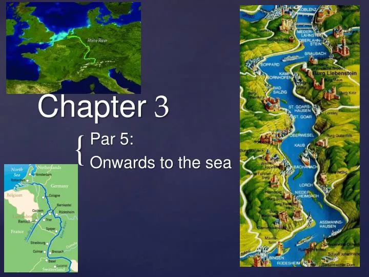
Chapter 3. Par 5: Onwards to the sea. Rhine divided into sections: Oberrhein = Upper Rhine Plain. In the Upper Rhine graben , the valley is approximately 50 km wide.

E N D
Chapter 3 Par 5: Onwardsto the sea
In the Upper Rhine graben, the valley is approximately 50 km wide Upper Rhine graben: when the surface is stretched out too much, the continent breaks and become a much lower part than the surrounding area.
Horst Horst Graben or rift :The earth’s crust is extended and afterwards collapsed. Horst: higher surrounding area’s.
Basel: start of the middle course of the Rhine wide river, no mountains in the area.
The forming of meanders: sediments transported in the river batter the walls of the river. Fast flowing water cause erosion of the outer bend, slow flowing water causes sedimentation/ deposition on the inner bend.
meander Oxbow lake: a U-shaped lake formed when a wide meander is cut off to create a lake.
RomanticRhine: Along the middle course of the Rhine there are a lot of castles (burgs)
The lower Rhine: almost no relief a wide, flat river valley
Length 1 238,8 km Height (source) 1 602 m Fall 1 602 m (from source to sea level) Drop 1,214 m/km Length 150 m Altitude 12m Altitude 0 m Fall in the Netherlands 12 m Drop in the Netherlands Drop (verhang): the fall (verval) of a river per kilometre