Download
1 / 35
360 likes | 502 Vues
The ESA Earth Explorer Missions. C.J. Readings Earth Science Division Estec. The Earth System - Four Key Points. • The need to address public concerns about the Earth, its environment and mankind’s impact on it.

E N D
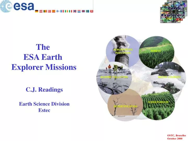
The ESA Earth Explorer Missions C.J. Readings Earth Science Division Estec
The Earth System - Four Key Points • The need to address public concerns about the Earth, its environment and mankind’s impact on it. • The Earth is a complex (and evolving) system which is not properly understood. • Data required to improve knowledge of the processes involved, to develop and validate models. • Space has a role to play in the helping to ensure the provision of the requisite data. See Earth Explorers: Science and Research Elements of ESA’s Living Planet Programme (ESA SP-1227)
The Earth System - Illustrative Observations Flooding in Mozambique (Landsat)
The Earth System - Illustrative Observations Los Alamos before and after the fire (Landsat)
The Earth System - Illustrative Observations NO2 emission over Europe
The Earth System - Illustrative Observations Ozone ‘holes’
The Earth System - Illustrative Observations Calving of an ice sheet from the Ronna Ice Shelf
True? El Niño
Earth System Models Understanding of the Earth will improve by the development and elaboration of global Earth System models which describe: • the evolution of the state and composition of the atmosphere • the physical state of the ocean and cryosphere • the physical state of the top few metres of soil and dynamical interactions with the Earth’s interior • the physical state of terrestrial vegetation • the key bio-geochemical cycles which in turn require the representation of terrestrial and ocean biota See Earth Explorers: Science and Research Elements of ESA’s Living Planet Programme (ESA SP-1227)
Earth System Models - An Iterative Process See Earth Explorers: Science and Research Elements of ESA’s Living Planet Programme (ESA SP-1227)
The Four Themes Four major interdisciplinary themes identified: • Theme 1 - Earth Interior • Theme 2 - Physical Climate System • Theme 3 - Geosphere-Biosphere • Theme 4 - Anthropogenic Influences on the Atmospheric and Marine Environment The four Themes span the full Earth System and recognise the need for the detailed treatment of interactions between the regimes. See Earth Explorers: Science and Research Elements of ESA’s Living Planet Programme (ESA SP-1227)
Theme 1 - Earth Interior (1) • Marine Geoid and • Ocean Circulation • Gravity Field • and Earth Interior • Processes • Magnetic Field • and Earth Interior • Processes • Geodesy See Earth Explorers: Science and Research Elements of ESA’s Living Planet Programme (ESA SP-1227)
Theme 1 - Earth Interior (2) See Earth Explorers: Science and Research Elements of ESA’s Living Planet Programme (ESA SP-1227)
Theme 2 - Physical Climate See Earth Explorers: Science and Research Elements of ESA’s Living Planet Programme (ESA SP-1227)
The Physical and Biophysical Systems See Earth Explorers: Science and Research Elements of ESA’s Living Planet Programme (ESA SP-1227)
Theme 3 - Geosphere/Biosphere See Earth Explorers: Science and Research Elements of ESA’s Living Planet Programme (ESA SP-1227)
Theme 4 - Anthropogenic Impact (1) • Changes in Atmospheric Composition Induced by Human Activity • Chemical Processes in the Stratosphere and Upper Troposphere • Marine Pollution See Earth Explorers: Science and Research Elements of ESA’s Living Planet Programme (ESA SP-1227)
Theme 4 - Anthropogenic Impact (2) See Earth Explorers: Science and Research Elements of ESA’s Living Planet Programme (ESA SP-1227)
The Earth Explorer Missions - General Characteristics (1) • • Means of addressing objectives (see ESA SP-1227) • • Regular flight opportunities funded under the Earth Observation Envelope Programme • • Objectives of Earth Explorer Missions - research and development focussing on specific topics/techniques • • Two complementary types of Earth Explorer missions, namely: • Earth Explorer Core Missions - larger research/demonstration missions led by ESA. • Earth Explorer Opportunity Missions - smaller research and demonstration missions not necessarily ESA led. • • Complemented by Earth Watch - thematic pre-operational missions focussing on specific emerging Earth Observation application areas See Earth Explorers: Science and Research Elements of ESA’s Living Planet Programme (ESA SP-1227)
The Overall Scenario Earth Observation Future Missions Earth Watch Earth Explorer research oriented, also demonstration of new observation techniques Operational, service oriented missions Core Missions OpportunityMissions smaller, faster missions, not necessarily ESA led larger missions, ESA led GOCE AEOLUS / ADM CRYOSAT SMOS see <http:/www.estec.esa.nl/explorer/>
The Earth Explorer Missions - General Characteristics (2) • Within Financial Envelope - flexibility in allocation of resources • Cyclic Process • Regular Flight Opportunities Illustrative diagram see <http:/www.estec.esa.nl/explorer/>
GOCE Mission Objectives • Studies in: • Solid Earth Physics - anomalous density structure of lithosphere and upper mantle • Oceanography - dynamic ocean topography and absolute ocean circulation • Ice Sheet Dynamics - ice sheet mass balance • Geodesy - unified height systems • Sea Level change • Determine Earth’s gravity field and its geoid (equipotential surface for a hypothetical ocean at rest): • high accuracy (1 mgal and 1 cm) • fine spatial resolution (~ 100 km) see <http:/www.estec.esa.nl/explorer/>
The GOCE Technical Concept • Gradiometry and precise satellite orbit tracking (high-low satellite to satellite tracking) • 2 key instruments: • Capacitive 3-axis gradiometer • GPS-GLONASS receiver • Mission duration: 20 months • Orbit: 250 km altitude, sun-sync. • Launch in 2004/2005 see <http:/www.estec.esa.nl/explorer/>
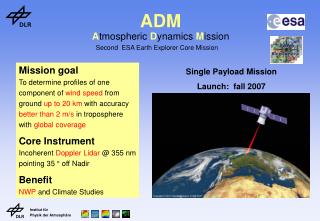
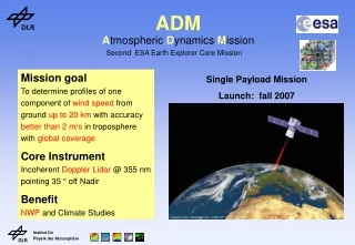
Aeolus-ADM Mission Objectives • Measures atmospheric winds in clear air to: • Improve parameterisations of atmospheric processes in models • Advance climate and atmospheric flow modelling • Provide better initial conditions for weather forecasting • Using: • A Doppler Wind Lidar operating in the UV (355 nm) • Two channel receiver to detect aerosol and molecular backscatter signal see <http:/www.estec.esa.nl/explorer/>
The ADM Technical Concept • Main mission parameters: • sun-synchronous orbit • ~400 km altitude • dawn-dusk crossing time • Main instrument characteristics • Doppler Wind Lidar operating in the UV (355 nm) • Two channel receiver to detect aerosol and molecular backscatter signal • Main sampling characteristics • LOS perpendicular to orbit plane • Vertical resolution: 0-2 km 500 m2-16 km 1 km16-27 km 2 km see <http:/www.estec.esa.nl/explorer/>
CryoSat Mission Objectives • Research goals: • Study of mass imbalances of Antarctic and Greenland ice sheets • Investigate the influence of the Cryosphere on global sea level rise • Use of sea ice thickness information for advances in Arctic and global climate studies • Measures variations in the thickness of the polar ice sheets and thickness of floating sea ice • Uses a Ku-band radar altimeter: • conventional pulse limited mode • synthetic aperture processing along track (over sea ice) • Interferometric processing across track (over ice sheets) see <http:/www.estec.esa.nl/explorer/>
CryoSat Technical Concept • Ku-band radar altimeter in three operation modes: • Conventional pulse limited mode • Synthetic aperture processing along track (over sea ice) • Interferometric processing across track (over ice sheets) • Mission duration: 3 years • High inclination orbit with 500-600 km altitude • Launch in 2003 see <http:/www.estec.esa.nl/explorer/>
SMOS Mission Objectives • To demonstrate the use of L-band 2-D interferometry to observe: • salinity over oceans, • soil moisture over land • ice characteristics • To advance the development of climatological, hydrological and meteorological models. see <http:/www.estec.esa.nl/explorer/>
SMOS Technical Concept • passive microwave radiometer (L-band - 1.4GHz) • 2D interferometry • multi-incident angles (0°-55º) • polarimetric observations • spatial resolution: 20-50km • revisit time: 1-3 days • mission duration: 3-5 years see <http:/www.estec.esa.nl/explorer/>
To provide data for:- atmospheric analysis and modelling studies of energy balance and transport Exploits the refraction of signals from GNSS satellites to provide: temperature soundings (1 K at 1 km vertical resolution in the stratosphere); humidity soundings (10 % in the troposphere); => Averaged values of 0.1 K in temperature and 2 % in humidity ACE Mission Objectives see <http:/www.estec.esa.nl/explorer/>
ACE Technical Concept • 6 satellites in 2 planes separated 90O in longitude. • 800 km altitude, 75O inclination. • 80 kg, 60 W, 50 kbps satellite. • Near-real time data assimilation see <http:/www.estec.esa.nl/explorer/>
The Earth Explorer Missions - Overall Situation • 1. In addition to ACE the reserve list of Earth Explorer Opportunity Missions: • SWARM - observation of the Earth’s magnetic field • SWIFT - measurement of stratospheric winds using a Doppler interferometer • 2. SWIFT and GRAS under consideration for GCOM (Japanese satellite) • 3. Work in support of potential future missions - notably atmospheric chemistry, land surface and Earth’s radiation budget • 4. A call for ideas for the next Earth Explorer Core Missions was issued on 1 June 2000; deadline for receipt of proposals 1 September 2000 • 5. The next call for Earth Explorer Opportunity Missions is planned for 2001 see <http:/www.estec.esa.nl/explorer/>
The Future - examples of other activities • Precipitation - use of passive microwave radiometers on drone satellites (possible European contribution to Global Precipitation Mission) • DIAL - use of DIAL to measure water vapour and carbon dioxide • PARIS - use of reflected GNSS signals for altimetry and sea state (wind and wave) • FLEX - observation of fluorescence as an indicator of vegetation condition and state • SAR - development of P-band, Ku-band; scientific exploitation of operational missions in L-, C- and X-band, including multi-static configurations • Geostationary missions - catalogue of ideas, carrier requirements • Solid Earth - superconducting gravity gradiometry; accelerometers; one axis gradiometers ; high performance drag compensation systems • Satellite Formations - analysis tool being developed • Fire Detection - algorithm development