Download
1 / 1
10 likes | 98 Vues
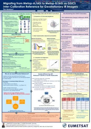
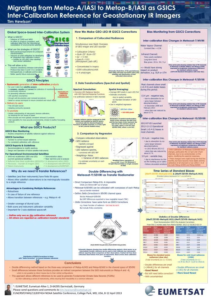
Migrating from Metop-A/IASI to Metop-B/IASI as GSICS Inter-Calibration Reference for Geostationary IR Imagers Tim Hewison 1. How We Make GEO-LEO IR GSICS Corrections. Bias Monitoring from GSICS Corrections. Global Space-based Inter-Calibration System. 1. Comparison of Collocated Radiances.

E N D
Migrating from Metop-A/IASI to Metop-B/IASI as GSICS Inter-Calibration Reference for Geostationary IR ImagersTim Hewison1 How We Make GEO-LEO IR GSICS Corrections Bias Monitoring from GSICS Corrections Global Space-based Inter-Calibration System 1. Comparison of Collocated Radiances • What is GSICS? • Initiative of CGMS and WMO • An effort to produce consistent, well-calibrated data from the international constellation of environmental satellites • What are the strategies of GSICS? • Best practices/requirements for prelaunch characterisation • Improve on-orbit calibration by developing an integrated inter-calibration system • Initially by LEO-GEO Inter-satellite/inter-sensor calibration • This will allow us to: • Improve consistency between instruments • Produce less bias in Level 1 & 2 products • Retrospectively re-calibrate archive data • Better specify future instruments Inter-calibration Bias Changes in Meteosat-7/MVIRI • Simultaneous near-Nadir Overpass • of GEO imager and LEO sounder • Collocation Criteria: • ΔLat<35° ΔLon<35° • Δt < 5 min • Δsecθ < 0.01 (Atmospheric path diff.) • Concentrated in tropics • ~1000 collocations/orbit • ~1-4 orbit/night • Water Vapour Channel: • Constant Bias ~+2.5K • Infrared Channel: • Twice yearly oscillation • Long-term trend • Bias grows -2K to -3K / 5 yr • => Would have strong impact on product derivation, e.g. OLR or UTH Time series plot showing relative bias of IR channels of Meteosat-7/MVIRI (MSG2) wrt Metop-A/IASI, expressed as brightness temperature difference for standard radiance scenes (1976 US Standard Atmosphere with clear sky). Schematic illustration of the geostationary orbit (GEO) and polar low Earth orbit (LEO) satellites and distribution of their collocated observations Inter-calibration Bias Changes in Meteosat-9/SEVIRI GSICS Principles 2. Data Transformations (Spectral and Spatial) • Systematic generation of inter-calibration products • for Level 1 data from satellite sensors • to compare, monitor and correct the calibration of monitored instruments to community references • by generating calibration corrections • with specified uncertainties • through well-documented, peer-reviewed procedures • based on various techniques to ensure consistent and robust results • Delivery to users • Free and open access • Adopting community standards • To promote • Greater understanding of instruments’ absolute calibration, by analysing the root causes of biases • More accurate and more globally consistent retrieved L2 products • Inter-operability for more accurate environmental, climate & weather forecasting products Most channels show small (<0.4 K) and stable biases during this period. 13.4 μm : negative bias, • due to absorption by ice • grew larger between decontaminations • in December 2008 and February 2013 • when bias was reduced by about 0.7 K. Spectral Convolution: • Convolve LEO Radiance Spectra with GEO Spectral Response Functions • to synthesise radiance in GEO channels Spatial Averaging: • Average GEO pixels in each LEO FoV • Estimate uncertainty • due to spatial variability • as Standard Deviation of GEO pixels • Use in weighted regression TRACEABILITY / UNBROKEN CHAINS OF COMPARISONS Time series plot showing relative bias of IR channels of Meteosat-9/SEVIRI (MSG2) wrt Metop-A/IASI, expressed as brightness temperature difference for standard radiance scenes. LEO FoV~12km ~ 5x5 GEO pixels Inter-calibration Bias Changes in Meteosat-10/SEVIRI Illustration of spatial transformation. Small circles represent the GEO FoVs and the two large circles represent the LEO FoV for the extreme cases of FY2-IASI, where n xm=3x3 and SEVIRI-IASI, where n xm=5x5 Example radiance spectra measured by IASI (black) and modeled by LBLRTM (grey), convolved with the Spectral Response Functions of SEVIRI channels 3-11 from right to left (colored shaded areas). 2012-07-05 Launched 2012-12-12 Operational Small (<0.4 K) biases in most channels 13.4 μm : negative bias, • due to absorption by ice • grew larger between decontaminations • in 2012-08 and 2013-12 • when bias was reduced by about 0.7 K. • 3.9 μm : variable bias, • due to interference by thin ice film building up on optics • follows sinusoidal variations What are GSICS Products? GSICS Bias Monitoring • Routine comparisons of satellite radiances against reference GSICS Correction • Function to correct issued radiances • For consistent calibration with reference GSICS Reports & Guidelines • Recommendations to modify practices • Design and Operation of future satellite instruments For Operational Environmental Satellites Infra-red recalibration (GEO and LEO) Demonstration status (current operational satellites) Near real-time and re-analysis Reflected Solar Band recalibration (GEO/LEO) In development within GSICS Microwave – Sounders & Imagers (LEO) In development with GPM XCAL Historic Instruments In development at EUMETSAT… 3. Comparison by Regression • Compare collocated observations • GEO radiance • Spatially averaged • Regressed against • LEO radiance spectra, • convolved with GEO SRF • Weighting= Noise + Variance of GEO radiances • to estimate uncertainty on each collocation Time series plot showing relative bias of IR channels of Meteosat-10/SEVIRI (MSG2) wrt Metop-A/IASI, expressed as brightness temperature difference for standard radiance scenes • Inter-calibration of Meteosat-10/SEVIRI show changes, particularly the 13.4μm and 3.9μm channels, due to ice contamination on the optics, modifying the spectral responses. • These changes were rapid during the first few months, but have become more stable and the calibration of all channels is now within 1 K of the both Metop-A/IASI and Metop-B/IASI. Weighted linear regression of LGEO|REF and <LGEO> for Meteosat-9 13.4μm channel based on single overpass of IASI Why do we need to transfer References? Double-Differencing with Meteosat-9/SEVIRI as Transfer Radiometer Time Series of Standard Biases(Met9/SEVIRI-MetopB/IASI) & (Met9/SEVIRI-MetopA/IASI) Shaded areas represent k=1 uncertainty • Satellites (and their instruments) have finite life spans • Allows other satellite’s observations to be metrologically traceable to a single reference • Advantages in Combining Multiple References • Robustness • In case of failure of one reference • Allows transition between references – e.g. Metop-A->B • Greater coverage of diurnal cycle • Both scene and instrument calibration variability • Important for 3-axis stabilized spacecraft • Define only one as the calibration reference • All others are regarded as calibration transfer standards • Direct Comparison Metop-B & -A impossibleOrbits are 50min/180° out of phase • Meteosat-9/SEVIRI can be collocated with overpasses of each Metop • Use as transfer standard • Define Delta Corrections in SEVIRI channel space • Strictly Meteosat-9/SEVIRI • But SRF Differences expected to have negligible impact (TBC) • Delta Corrections have same form as GSICS Corrections • e.g. linear function of radiance – but may be zero! • But include finite uncertainty Statistics of Double Difference (Met9/SEVIRI-MetopB/IASI)-(Met9/SEVIRI-MetopA/IASI) • From Demonstration GSICS Re-Analysis Corrections • From first 2 months data from Metop-B/IASI: 2012-12-16/2013-02-14 Schematic diagram showing how double differencing against a third sensor as an intermediate transfer reference can be used to inter-calibrate two instruments without requiring direct comparison of their observations. Dashed red lines show collocated observations from pairs of instruments. Black arrows show calibration transfers. Biases for standard scene radiances (clear sky) • [Total Uncertainty (k=1) ~0.01K] • Double differences are small (<|40mK|) for all channels • Good News! • But still need delta correction! • With uncertainties! • Biases for cold cloud radiances (220K) • [Total Uncertainty (k=1) :~0.7K for IR3.9 ~0.2K for IR10.8] • Double differences are small (<|1K|) for all channels • More Good News! Distribution of GSICS Corrections to Users with “Delta Correction” to Convert between references Conclusions • Double differencing method based on the three-way comparison of Metop-A/IASI and Metop-B/IASI in the channel space of SEVIRI • Small differences between these functions provides an indirect comparison between the IASI instruments on Metop-A and –B, • - which is not possible by direct means due to their orbital configurations • This approach allows different references to be used to generate Fundamental Climate Data Records (FCDRs) • by inter-calibrating a series of instruments, while ensuring their traceability to a common reference 1: EUMETSAT, Eumetsat-Allee 1, D-64295 Darmstadt, Germany Please send questions and comments to tim.hewison@eumetsat.int EUM/RSP/VWG/13/697414 NOAA Satellite Conference, College Park, MD, USA, 8-12 April 2013