Download
1 / 70
700 likes | 716 Vues
Chapter 7 Climate and Biodiversity. Core Case Study: Different Climates Support Different Life Forms. Climate -- long-term temperature and precipitation patterns – determines which plants and animals can live where Tropical: equator, intense sunlight Polar: poles, little sunlight

E N D
Chapter 7 Climate and Biodiversity
Core Case Study: Different Climates Support Different Life Forms • Climate -- long-term temperature and precipitation patterns – determines which plants and animals can live where • Tropical: equator, intense sunlight • Polar: poles, little sunlight • Temperate: in-between tropical and polar
Three Major Climate Zones Fig. 7-1, p. 147
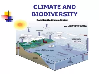
7-1 What Factors Influence Climate? • Concept 7-1 Key factors that determine an area’s climate are incoming solar energy, the earth’s rotation, global patterns of air and water movement, gases in the atmosphere, and the earth’s surface features.
The Earth Has Many Different Climates • Weather Set of physical conditions in the troposphere (the lower atmosphere): • Temperature, precipitation, wind speed, cloud cover, Humidity • Time Span: Hours to days • Climate • Area’s general pattern of atmospheric conditions over periods ranging from 3 decades to thousands of years. • Climate is the SUM of weather conditions in a given area, averaged over a long period of time.
Natural Capital: Generalized Map of the Earth’s Current Climate Zones Fig. 7-2, p. 149
Arctic Circle Labrador current Oyashio current North Atlantic drift Alaska current California current Canaries current North Pacific drift Kuroshio current Gulf stream Tropic of Cancer North equatorial current Monsoon Caribbean current drift Guinea current Equatorial counter current South equatorial North equatorial current South equatorial current current South equatorial current Brazil current Tropic of Capricorn West Australian current East Australian current Peru current Benguela current West wind drift West wind drift West wind drift Antarctic Circle Polar (ice) Subarctic (snow) Cool temperate Highland Warm ocean current River Warm temperate Dry Tropical Major upwelling zones Cold ocean current Fig. 7-2, p. 149
The Earth Has Many Different Climates • Air circulation in lower atmosphere due to • Uneven heating of the earth’s surface by sun: Sun hits the earth more directly at the equator, so smaller areas are delivered more heat. At poles the light is indirectly angled so the heat is spread over a larger area. • Rotation of the earth on its axis: Equator spins faster than regions north or regions south. Locations farther from the equator spin slower. The atmosphere over these areas are divided into areas called cells. Cells:Distinguished by their differing directions of air movement. 3.Properties of air, water, and land: Heat from the sun evaporates water and transfers heat to the atmosphere. This transfer forms convection cells that circulate heat, air, and moisture from place to place and vertically.
Global Air Circulation Fig. 7-3, p. 149
Moist air rises, cools, and releases moisture as rain Polar cap Cold deserts 60°N Air cools and descends at lower latitudes. Evergreen coniferous forest The highest solar energy input is at the equator. Westerlies Temperate deciduous forest and grassland 30°N Northeast trades Hot desert Tropical deciduous forest Warm air rises and moves toward the poles. Solar energy Equator 0° Tropical rain forest Tropical deciduous forest Hot desert Southeast trades Air cools and descends at lower latitudes. 30°S Temperate deciduous forest and grassland Westerlies Cold deserts 60°S Polar cap Fig. 7-3, p. 149
LOW PRESSURE HIGH PRESSURE Heat released radiates to space Condensation and precipitation Cool, dry air Falls, is compressed, warms Rises, expands, cools Warm, dry air Hot, wet air Flows toward low pressure, picks up moisture and heat LOW PRESSURE HIGH PRESSURE Moist surface warmed by sun Fig. 7-4, p. 150
Energy Transfer by Convection in the Atmosphere Fig. 7-4, p. 150
The Earth Has Many Different Climates • Ocean currents • Prevailing winds • Earth’s rotation • Redistribution of heat from the sun due to differing densities of warm vs. cool water • Surface currents and deep currents
Connected Deep and Shallow Ocean Currents Fig. 7-5, p. 150
Warm, less salty, shallow current Cold, salty, deep current Fig. 7-5, p. 150
The Earth Has Many Different Climates • El Niño-Southern Oscillation • Every few years • Prevailing winds in tropical Pacific Ocean change direction • Affects much of earth’s weather for 1-2 years • Link between air circulation, ocean currents, and biomes
Normal and El Niño Conditions Figure 4, Supplement 7
Impact of El Nino-Southern Oscillation Figure 5, Supplement 7
Greenhouse Gases Warm the Lower Atmosphere • Greenhouse gases • H2O • CO2 • CH4 • N2O • Natural greenhouse effect • Gases keep earth habitable • Human-enhanced global warming
Flow of Energy to and from the Earth Fig. 3-4, p. 57
Earth’s Surface Features Affect Local Climates • Differential heat absorption by land and water • Land and sea breezes • Rain shadow effect • Most precipitation falls on the windward side of mountain ranges • Deserts leeward • Cities create microclimates
Rain Shadow Effect Fig. 7-6, p. 152
Prevailing winds pick up moisture from an ocean. On the windward side of a mountain range, air rises, cools, and releases moisture. On the leeward side of the mountain range, air descends, warms, and releases little moisture, causing rain shadow effect. Fig. 7-6, p. 152
7-2 How Does Climate Affect the Nature and Locations of Biomes? • Concept 7-2 Differences in average annual precipitation and temperature lead to the formation of tropical, temperate, and cold deserts, grasslands, and forests, and largely determine their locations.
Climate Helps Determine Where Organisms Can Live • Major biomes: large land regions with certain types of climate and dominant plant life • Not uniform • Mosaic of patches • Latitude and elevation • Annual precipitation • Temperature
The Earth’s Major Biomes Fig. 7-7, p. 153
North America Biomes Figure 3, Supplement 8
Generalized Effects of Elevation and Latitude on Climate and Biomes Fig. 7-8, p. 153
Elevation Mountain ice and snow Tundra (herbs, lichens, mosses) Coniferous Forest Latitude (south to north) Deciduous Forest Tropical Forest Tropical Forest Deciduous Forest Coniferous Forest Tundra (herbs, lichens, mosses) Polar ice and snow Fig. 7-8, p. 153
Elevation Mountain ice and snow Tundra (herbs, lichens, mosses) Coniferous Forest Deciduous Forest Latitude Tropical Forest Coniferous Forest Tundra (herbs, lichens, mosses) Deciduous Forest Tropical Forest Polar ice and snow Stepped Art Fig. 7-8, p. 153
Natural Capital: Average Precipitation and Average Temperature as Limiting Factors Fig. 7-9, p. 154
Cold Arctic tundra Cold desert Evergreen coniferous forest Temperate desert Temperate deciduous forest Temperate grassland Chaparral Tropical desert Hot Wet Tropical rain forest Dry Tropical grassland (savanna) Fig. 7-9, p. 154
Global Plant Biodiversity Figure 6, Supplement 8
Tropic of Cancer Equator High mountains Polar ice Arctic tundra (cold grassland) Temperate grassland Tropic of Capricorn Tropical grassland (savanna) Chaparral Coniferous forest Temperate deciduous forest Temperate rain forest Tropical rain forest Tropical dry forest Desert Fig. 7-7, p. 153
There Are Three Major Types of Deserts • Tropical deserts • Temperate deserts • Cold deserts • Fragile ecosystem • Slow plant growth • Low species diversity • Slow nutrient recycling • Lack of water
Climate Graphs of Three Types of Deserts Fig. 7-10, p. 155
Stepped Art Fig. 7-10, p. 155
Temperate Desert Ecosystem in North America Figure 1, Supplement 6
Science Focus: Staying Alive in the Desert • Beat the heat/every drop of water counts • Plant adaptations • Succulents • Deep tap roots • Animal strategies and adaptations • Physiology and anatomy • Behavior
Wildflowers Bloom after Rain in Arizona Fig. 7-A, p. 156
There Are Three Major Types of Grasslands (1) • Tropical • Temperate • Cold (arctic tundra)
Climate Graphs of Tropical, Temperate, and Cold Grasslands Fig. 7-11, p. 157
Stepped Art Fig. 7-11, p. 157
There Are Three Major Types of Grasslands (2) • Tropical • Savanna • Grazing animals • Browsing animals • Temperate • Cold winters and hot and dry summers • Tall-grass prairies • Short-grass prairies • Often converted to farmland
Temperate Tall-Grass Prairie Ecosystem in North America Figure 2, Supplement 6
There Are Three Major Types of Grasslands (3) • Arctic tundra: fragile biome • Plants close to ground to conserve heat • Most growth in short summer • Animals have thick fur • Permafrost • Underground soil that stays frozen • Alpine tundra: above tree line in mountains
Monoculture Crop Replacing Biologically Diverse Temperate Grassland Fig. 7-12, p. 158
Temperate Shrubland: Nice Climate, Risky Place to Live • Chaparral • Near the sea: nice climate • Prone to fires in the dry season
There Are Three Major Types of Forests (1) • Tropical • Temperate • Cold • Northern coniferous and boreal
Climate Graphs of Tropical, Temperate, and Cold Forests Fig. 7-13, p. 160