Download
1 / 11
310 likes | 989 Vues
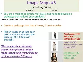
Image Maps. Lecture 14. Image Maps. An image map is a single image that can be used to link to several different URLS. Hot Spots. Image Maps. Server-Side Image Maps Client-Side Image Maps Summary: Image Maps. Image used as image map

E N D
Image Maps Lecture 14
Image Maps • An image map is a single image that can be used to link to several different URLS Hot Spots
Image Maps • Server-Side Image Maps • Client-Side Image Maps • Summary: Image Maps
Image used as image map Map file defines areas of image and corresponding URLs Image map program runs on server as part of its server software Map file and image map program reside on server Web server performs calculations Server-Side Image Maps Image Maps
HTML document contains map information Browser performs calculations Better performance that server-side image maps Can test and implement locally URL of hyperlink will display in browser status bar when mouse hovers over image Client-Side Image Maps
Select image to use Define areas of image map Three shapes: circle, rectangle, polygon X and Y coordinates in pixels Get coordinates from a graphics program such as Paint Shop Pro or Photoshop Four Steps to Create a Client-Side Image Map
Four Steps to Create a Client-Side Image Map • Include map information in HTML document: • <MAP></MAP> - NAME attribute names the map • <AREA> tags identify shapes in map • SHAPE attribute – circle, rect, poly • HREF attribute – URL to load • COORDS – x and y coordinates of shape • Connect image with map information • USEMAP attribute in <IMG> tag • USEMAP value is map name with a # symbol before it
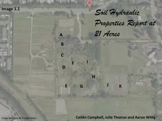
Finding Coordinates • Open image in Irfanview or some other graphics program • Point to the locations of interest and click to see the X, Y coordinates in the title bar
x,y x+r,y Circle <AREA SHAPE=“circle” COORDS=“x,y,r” HREF=“url”> • Replace x,y,r with three numbers: horizontal and vertical position of the circle’s center, and the radius of the circle in pixels • Replace url with the Web address of the link target
x1,y1 x2,y2 Rectangle <AREA SHAPE=“rect” COORDS=“x1,y1,x2,y2” HREF=“url”> • Replace x1,y1 with two numbers: horizontal and vertical position of one corner of the rectangle • Replace x2,y2 with the horizontal and vertical position of the opposite corner of the rectangle • Replace url with the Web address of the link target
x1,y1 x2,y2 x6,y6 x3,y3 x5,y5 x4,y4 Polygon <AREA SHAPE=“poly” COORDS=“x1,y1,x2,y2,x3,y3,x4,y4,…” HREF=“url”> • Replace x1,y1 with two numbers: horizontal and vertical position of a point on the edge of the polygon • Add more x,y pairs until you have traced around the desired shape