Download
1 / 1
10 likes | 132 Vues
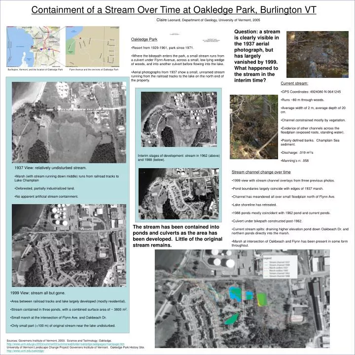
Containment of a Stream Over Time at Oakledge Park, Burlington VT. Claire Leonard, Department of Geology, University of Vermont, 2005. Question: a stream is clearly visible in the 1937 aerial photograph, but has largely vanished by 1999. What happened to the stream in the interim time?.

E N D
Containment of a Stream Over Time at Oakledge Park, Burlington VT Claire Leonard, Department of Geology, University of Vermont, 2005 Question: a stream is clearly visible in the 1937 aerial photograph, but has largely vanished by 1999. What happened to the stream in the interim time? • Oakledge Park • Resort from 1929-1961, park since 1971. • Where the bikepath enters the park, a small stream runs from a culvert under Flynn Avenue, across a small, low-lying wedge of woods, and into another culvert before flowing into the lake. • Aerial photographs from 1937 show a small, unnamed stream running from the railroad tracks to the lake on the north end of the property. Burlington, Vermont, and the location of Oakledge Park Flynn Avenue and the environs of Oakledge Park • Current stream: • GPS Coordinates: 4924080 N 0641245 • Runs ~80 m through woods. • Average width of 2 m, average depth of 20 cm. • Channel constrained mostly by vegetation. • Evidence of other channels across the floodplain (exposed roots, standing water). • Poorly defined banks. Champlain Sea sediment. • Discharge: .019 m3/s • Manning’s n: .058 Interim stages of development: stream in 1962 (above) and 1988 (below). Interim stages of development: stream in 1962 (above) and 1988 (below). • 1937 View: relatively undisturbed stream. • Marsh (with stream running down middle) runs from railroad tracks to Lake Champlain • Deforested, partially industrialized land. • No apparent artificial stream containment. • 1937 View: relatively undisturbed stream. • Marsh (with stream running down middle) runs from railroad tracks to Lake Champlain • Deforested, partially industrialized land. • No apparent artificial stream containment. • Stream channel change over time • 1999 view with stream channel overlays from three previous photos. • Pond boundaries largely coincide with edges of 1937 marsh. • Channel has meandered all over small floodplain north of Flynn Ave. • Lake shoreline has retreated. • 1988 ponds mostly coincident with 1962 pond and current ponds. • Culvert under bikepath constructed post-1962. • Current stream splits: draining higher elevation pond down Oakbeach Dr. and northern ponds directly into the marsh. • Marsh at intersection of Oakbeach and Flynn has been present in some form throughout. The stream has been contained into ponds and culverts as the area has been developed. Little of the original stream remains. • 1999 View: stream all but gone. • Area between railroad tracks and lake largely developed (mostly residential). • Stream contained in three ponds, with a combined surface area of ~ 3800 m2. • Small marsh at the intersection of Flynn Ave. and Oakbeach Dr. • Only small part (<100 m) of original stream near the lake undisturbed. • 1999 View: stream all but gone. • Area between railroad tracks and lake largely developed (mostly residential). • Stream contained in three ponds, with a combined surface area of ~ 3800 m2. • Small marsh at the intersection of Flynn Ave. and Oakbeach Dr. • Only small part (<100 m) of original stream near the lake undisturbed. Sources: Governers Institute of Vermont, 2003. Science and Technology: Oakledge. http://www.uvm.edu/giv/2003/summer03/summerwebfolder/oakledge/webpages/mainpage.htm University of Vermont Landscape Change Project/ Governers Institute of Vermont. Oakledge Park History Site. http://www.uvm.edu/oakledge/