Download
1 / 41
410 likes | 413 Vues
Explore the evidence to determine if Mt. Baker, Crater Mtn, and Mt. Pilchuck are volcanic mountains. Study photos, maps, and geological features to make your conclusions.

E N D
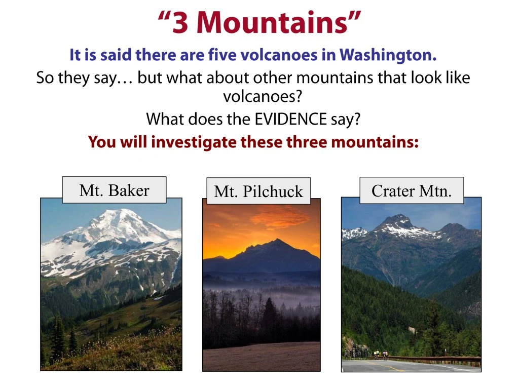
“3 Mountains” It is said there are five volcanoes in Washington. So they say… but what about other mountains that look like volcanoes? What does the EVIDENCE say? You will investigate these three mountains: Mt. Baker Crater Mtn. Mt. Pilchuck
To investigate each mountain, click on the pin.To return to this page, click on the map icon in the corner of each slide. Mt. Baker Crater Mtn Keep asking yourself: What evidence is there that these mountains are volcanoes? What evidence is there that they are not volcanoes? Keep asking yourself: What evidence is there that these mountains are volcanoes? What evidence is there that they are not volcanoes? Click Here to go back to FIRSTTitle Page Mt. Pilchuck
Return to map page Mt. Baker • Study the photo and map. What evidence is there that Mt. Baker is or is not a volcano? • After you have answered step 1, click the numbers on the map to investigate Mt. Baker’s geology. B8 B1 B2 B7 B4 B3 B6 B5
Return to map page Mt. Pilchuck • Study the photo and map. What evidence is there that Mt. Pilchuck is or is not a volcano? • After you have answered step 1, click the numbers on the map to investigate Mt. Pilchuck’s geology. P1 P4 P3 P2 P5 P6 P8 P7
Return to map page Crater Mountain • Study the photo and map. What evidence is there that Crater Mountain is or is not a volcano? • After you have answered step 1, click the numbers on the map to investigate Crater Mountain’s geology. C6 C5 C4 C2 C3 C1
P1. Forest Trail No geologic clues here! Just deep forest for the first couple miles. The rocks are all covered by soil and vegetation from over 50” of rain a year.
P2. Boulder Field Finally, you find rock: a large jumble of boulders. They’re covered with moss and lichen so you can’t see fresh surfaces. They are light colored though. And separate grains are slightly visible. • Write your observations. • List types of rock this could be.
P3. Round Feature What is this?? You’re noticing a few of these along the trail. Many have a perfectly round hole in the center. Could they be volcanic? • Describe the feature and list as many hypotheses as you can for how they formed.
P4. More Boulders Lots of exposed rock! You have to walk carefully because they’re broken and jagged. Look closer at that one broken piece with no lichen. Click on it.
P4 Broken Rock Back to More Boulders What kind of rock does this look like? Compare with rocks back in the lab. • Write notes, then click to see more detail.
P4 Close up Broken Rock Back to Broken Rock • Write detailed observations. • What kind of rock is this? • What does this indicate about Mt. Pilchuck’s origin?
P5. Three Holes More clues to the round features seen earlier. What do you think caused these? They’re in that same light grey rock. Are these volcanic features?
P6. More Rock • Write notes, then click to see more detail. This grey rock is everywhere! All the way to the top! It appears the whole mountain is made of it.
P6 Close up of Rock Back to More Rock
P7. Cracks like a Caterpillar What caused these cracks? Think about the climate high up on Mt. Pilchuck. Here’s another example.
Cracks Hard to tell if this will help answer your “volcanic origins” question, but a good geologist is a good detective and leaves no stone unturned when looking for clues! Back Another Example So again, what might have caused these kinds of cracks? The rock was broken right where it sits.
P8. Pilchuck Lookout You made it! Still more of that grey rock on top. Click on the tower to see other views from the top.
Back Views At the Top North/NW East Looking to Stanwood. Olympics behind. Mr. Stoddard stands tall! Glacier Peak Southwest E Lake Stevens, Everett, Puget Sound Early November. Ice covers everything. For pictures of Mr Shafer and Mr. McLeod’s Saturday trip to Mt. Pilchuck, click here.
Oops. If you’re reading this, you hit return instead of clicking on links. Start again here.
C1. Schist in the Woods There’s a bunch of schist alongside the trail. What type of rock is schist? What does this indicate about Crater Mountain? Write your inferences, then come back to this question again after you’ve visited Crater Mountain sites 3-6. Nearby, an old miner’s cabin.
C2. The “Crater” OK, you get a little help with this one since you haven’t studied glacial landforms. Hiking up about 5,000 feet you reach the crater that’s visible from the road. You realize this is a cirque with a small tarn. You make note of these features in your notebook. Does this mean Crater Mountain is not a volcano? The top of Crater Mountain. Still a ways to go! Click here for a picture from the top of Crater Mountain looking across the valley to where present day glaciers are carving out cirques right now.
C3. Greenstone What kind of rock did greenstone used to be? Where did it form? What does this rock suggest about Crater Mountain’s origins and if it is a volcano? See more greenstone at the top, when you get to stop #6.
C4. Pillow Basalt How do pillow basalts form*? How might they have ended up here at 8,000’ ? What does this rock suggest about Crater Mountain’s origins and if it is a volcano? * More info: http://geology.about.com/od/structureslandforms/ig/pillowlava/ * Video:http://oceanexplorer.noaa.gov/explorations/04fire/background/volcanism/media/pillow_lava_video.html
More views from the top. C6. Rocks on Top More rocks made of greenstone. Some are rust colored from the oxidation of iron. What process might have caused the rocks to pile up in this U-shape? Put all of your Crater Mountain evidence together… schist, greenstone, pillow basalt.
Back to Rocks on Top. Views From the Top North East Looking to Canada The road 6,000’ below South West Mountains and Glaciers Jack Mc in front of Jack Mountain photo by Paul Reed
back Mountains to the south Here too! Cirques are being carved by these glaciers.
Oops. If you’re reading this, you hit return instead of clicking on links. Start again here.
B1. Columnar Lava Columnar lava forms from quick cooling lava flows (in this case, andesite). Describe this rock formation. Here’s another view just up the road. You’re about 5 miles northwest of Mt. Baker. Is this too far away or could these flows have come from Mt. Baker? Describe your thinking on this. photo by Scott Babcock
Back to Columnar Lava More Columnar Lava This time you’re walking over the tops of the columns. photo by Scott Babckock
B2. Tephra You’ve had these layers analyzed and learned the following: • The lower white layer is all the way from Mt. Mazama (Crater Lake, Oregon!). • Above it, the thick grey layer is from Mt. Baker. photo by Dave Tucker
B3. Hot Spring You’re in the woods about 4 miles east of Mt. Baker. This hot spring is about 100f (hot bath water). You take a hot soak, wipe off the decaying leaves and pine needles then get back to work. Does the hot spring suggest Mt. Baker is a volcano? Do hot springs always occur near volcanoes? photo by Scott Babcock
B4. Boulder Creek Lahar What direction do lahars flow? Go back and look at the map. Where did these deposits come from? What inference(s) can you make? There is a geologist in both pictures. Do you see the one in this picture? Click on the picture. photos by Dave Tucker
B5. Cinder Cone At first you don’t notice what the forested hill in the middle of the picture is. But look closely…. describe it. • Look here too. • Is this feature enough evidence to conclude Mt. Baker is a volcano? Explain your reasoning. photo by Dave Tucker
Back to Cinder Cone Cinder Cone map
B6. More Tephra The light bands are ash layers. • The upper yellow band is from Mount Baker 6,600 years ago. • The lower white layer is from Mt. Mazama 7,700 years ago. USGS photo photo by Dave Tucker
B7. Sherman Crater There’s a steamy crater on top! Take a closer look. Wait… are there layers here? Take a closer look. Photos by John Scurlock
Back to Sherman Crater Fumaroles The crater has dozens, if not 100’s, of gas vents, mostly a few centimeters across, that emit H2O, CO2, H2S (hydrogen sulphide), and other gases. These geologists are collecting samples for analysis*. For more pictures and videos of the fumaroles, click here. * To see data on the gases, click here. What’s the most prevalent gas? . photo by Dave Tucker photo by W.Chadwick
Back to Sherman Crater Layers in the Crater The crater wall has layers of lava. Some of the lava has been chemically altered to white-yellow material rich in clays, silica, and sulfur-bearing minerals. Photo by John Scurlock
B8. Roosevelt Glacier Looking back at Mt. Baker from a ridge called Skyline Divide, you see lots of rock underneath the ice. The rocks are hardened lava flows, though from this distance it’s too hard to tell if they are basalt or andesite.
Oops. If you’re reading this, you hit return instead of clicking on links. Start again here.