Download
1 / 15
150 likes | 247 Vues
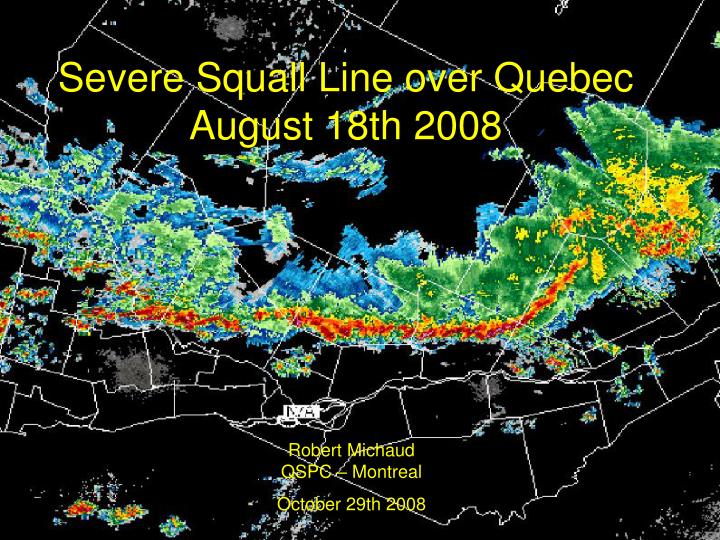
Severe Squall Line over Quebec August 18th 2008. Robert Michaud QSPC – Montreal October 29th 2008. Severe Squall Line – Aug 18th 2008. A strong thunderstorm line moved across western and southern regions of the province of Quebec;

E N D
Severe Squall Line over Quebec August 18th 2008 Robert MichaudQSPC – Montreal October 29th 2008
Severe Squall Line – Aug 18th 2008 • A strong thunderstorm line moved across western and southern regions of the province of Quebec; • Multiple reports of thunderstorm gusts (70 to 90 km/h) were received that day at the Quebec Storm Prediction Centre (QSPC) causing mostly tree damages ; • Few reports of hail were also received (1 to 2 cm); • 3 funnel clouds observations; • A few supercells have also developed ahead of the main line of thunderstorm with one particularly strong near Quebec City; • The Greater Montreal region was also hit without major damages;
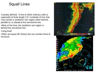
Severe Squall Line – Aug 18th 2008 (continued) • A few uncertainties remained on the intensity of the squall line as it approached the Greater Montreal area with the huge distance between the area of concern and the available radars that day; • A synoptic and thermodynamic analysis of this convective event will be done in the next few slides; • A radar analysis of the event will also be done with the help of the URP (Unified Radar Processor); • The radar data revealed that this Convective meso-scale event look like a well defined classical Squall line.
Synoptic Analysis A well defined low with frontal structure (Analysis of 12 and 18Z). Surface temperatures of 28ºC and dew point temperatures of 18 to 20ºC were reported in the warm sector.
Synoptic Analysis (continued) Long wave trough at 500 hPa with significative short wave trough rotating toward the east with winds of 45-55 knots at the base of the LWT (Analysis of 500 hPa at 12 and 00Z).
Synoptic Analysis (continued) We can clearly observed maximum winds at high and low levels (120 and 45 knots respectively) at the moment of the convective development at 18Z.
Convective Triggers Analysis • Low pressure centre over QC with frontal wave brushing SW QC; • Strong upper and lower jet streams under a SW-NE axis; • Humidity ridge in the warm sector with Td of 18 to 20 Celsius; • Upper short wave trough over western QC with wide area of PVA;
Thermodynamic Analysis (morning sounding of WMW) • Convective Available Potential Energy (CAPE) of 2000 J/Kg (with T=28 et Td=19); • SSI= 125 et LI=-6; • Wind shear 0-6 km of 45 knots (significative); • Average Cb tops of 42000 feet with maximum of 48000 feet; • We notice wind direction changes from southeast to northwest with altitude (above 500 hPa). Favourable wind shear for this type of event. Potential instability and latent instability under 750 hPa
Diagnosis/Forecasting • An area of Severe weather threat was delimited by late-morning covering the enhanced regions; • A first Severe weather watch was issued in the morning for western QC; • Later on, the Severe weather watch was extended to other regions of central QC as the Convective system progressed eastward during the day.
Satellite Imageries 12Z 15Z 18Z • We can notice the evolution of the Convective system as it moved over our regions (12, 15 et 18Z). This thunderstorm line persisted a long time since its development the day before over northwestern Ontario. Some dissipation was noticed during nightime near the Ontario-Quebec border before gaining again in strength in the afternoon of the 18th over our regions.
Radar Imageries • We will take a look of the evolution of this thunderstorm line with the support of the URP (Unified Radar Processor) display (mosaic of the QC radars). • We will also take a look to a cross-section of a Supercell that developed ahead of the main thunderstorm line;
Animation of the PRU mosaic (CAPPI at 1.5 km)
Radar Data Analysis (continued) • The left image is showing a vertical cross section of a cell that developed ahead of the main line at 19Z over the Quebec City region (in the red circle of the CAPPI image); • This cell was showing a well defined BWER with strong reflectivity to its southern flank, 45 dBz heights up to 11 km (very considerable for our region) and the presence of a mesocyclone; • This cell caused mainly flash flood rain over the region (between 20-30 mm) and a few minor damages caused by wind.
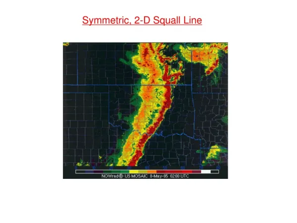
Final overview of the case • A line of thunderstorms caused multiple reports of gusty wind, small hail, a few funnel clouds and numerous lightning. This line brushed a great part of southwestern QC; • We highlighted this event for its classical structure; • As we saw on the radar data, the thunderstorm line was composed of a convective part and a stratiform part behind (characteristics of well defined squall line structure); • Despite the well organized aspect of this convective event, we were expecting more reports at the QSPC that day (we have to consider the limited density of the population north of the St. Lawrence river);
Final overview of the case (continued) • Severe weather watches and warnings were sent as the convective system was evolving across the province; • A great deal of uncertainties was existing on the intensity of the squall line has the system was approaching the Greater Montreal area. The McGill University radar was missing for that period; • A Severe weather warning was issued for the Greater Montreal area despite the diminishing intensity of the radar echoes from the two other radars (Ottawa and Quebec City).