Download
1 / 10
100 likes | 107 Vues
Chapter 3: Ancient Egypt and Nubia. Section 1 The Geography of the Nile. The Course of the Nile.

E N D
Chapter3:Ancient Egypt and Nubia Section 1 The Geography of the Nile
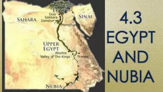
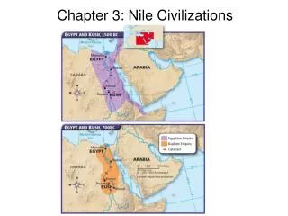
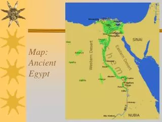
The Course of the Nile The Nile River is the longest river in the world. It starts in central Africa and flows north, and dumps into the Mediterranean Sea. The Nile is over 4,000 miles long, which is longer than the distance across the United States. The Nile has two main sources (the place a river starts) - The Blue Nile rises in the highlands of Ethiopia and the White Nile begins deep in central Africa. The two rivers meet at Khartoum, Sudan and travel north the the Mediterranean Sea.
The Nile Through Ancient Nubia From Khartoum northward, the Nile makes a large S shape. The northern tip of the S is at the city of Aswan in Egypt. The land from Khartoum to Aswan was once called Nubia. Farther south, between the Second and Sixth Cataracts was a region that was referred to as Upper Nubia. There is rainfall in upper Nubia, but there is only about two miles worth of farmland on either side of the river. The Nubian section of the Nile contained six rock-filled rapids called cataracts. Lower Nubia was between the First and Second Cataracts. Lower Nubia was had little farmland, and it didn’t rain much there.
The Nile Through Ancient Egypt The ancient Egyptian section of the Nile ran for about 700 miles, between the First Cataract at Aswan to the Mediterranean Sea. It passed through Upper Egypt, which was a narrow region of fertile soil. There was about 6 miles of fertile soil on each side of the river in Upper Egypt.
The Nile Through Ancient Egypt In the north, the Nile spread out to form a fertile, marshy area. This was called Lower Egypt. Dry deserts surrounded the river’s green banks. At the end of the nile, the river split into several streams that flowed into the Mediterranean Sea. These streams formed a delta, or triangle shape, of extremely fertile soil.
The Gifts of the Nile Every spring, waters came rushing down from the highlands. The rushing waters carried a rich, fertile soil called silt. Each spring the Nile flooded the dry land, and deposited a layer of the silt, which was ideal for farming.
Black Land and Red Land Beyond the fertile lands lay the vast deserts, or “red land.” Most of the Sahara Desert lay to the west of the Nile, and there was also desert lands on the east. The deserts were dangerous and could not grow anything. The deserts helped protect the ancient Egyptians from attackers. Unlike the wide open lands of Mesopotamia, which were constantly under attack, Egypt faced few invaders. The ancient Egyptians called their land Kemet, which meant “the black land.” The rich fertile soil that was left by the Nile’s floods was dark in color. The Egyptians could count on the floods nearly every year. Sometimes the floods would not come, which caused a famine.
Civilizations Along the Nile Communities began in the Nile delta of Lower Egypt by around 4000 B.C. These people built villages with straw and mud homes. The first Nubian communities appeared around 3800 B.C. Since farming was more difficult in Nubia, the Nubians also fished in the Nile River and hunted ducks for food.
The Growth of Trade The Nile River provided a great transportation route for trade. Ships could float downriver because the river flowed north. They could also sail upriver, because the wind blew toward the south. Trade routes over land also developed. Because of the cataracts, people could not travel through Nubia on the Nile River. The Nubians developed trade routes over land, and one went through the Nile River Valley. The Nubians became famous traders, and would bring things from central Africa to trade at bazaars in Egyptian cities.
Let’s Review! • How did the people of Ancient Egypt and Nubia benefit from the Geography of the Region? • How did the Nile operate as a “highway for trade?”