Download
1 / 29
330 likes | 1.39k Vues
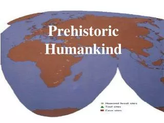
Prehistoric Landmasses. Gondwanaland. The hypothetical protocontinent of the Southern Hemisphere According to the theory of plate tectonics broke up into India, Australia, Antarctica, Africa, and South America. . Glossopteris. Glossopteris. Plant fossil

E N D
Gondwanaland • The hypothetical protocontinent of the Southern Hemisphere • According to the theory of plate tectonics • broke up into India, Australia, Antarctica, Africa, and South America.
Glossopteris • Plant fossil • 70 fossil species have been recognized in India alone • Additional species from South America, Australia, Africa, and Antarctica.
Cynognathus • A land reptile • Mammal-like • A worldwide distribution. • Fossils have so far been recovered from South Africa, South America, China and Antarctica.
Lystrosaurus • A land reptile • lived approximately 250 million years ago in what is now Antarctica, India and South Africa. • Lystrosaurs were medium-sized (about a meter long) herbivorous animals, approximately the size of a pig, with very stout limbs. • They had two long teeth protruding from their upper jaws. • Originally they were thought to be amphibious, a sort of small reptilian hippopotamus
Mesosaurus • A fresh water reptile • Came from amphibian ancestors • Its feet were webbed, body streamlined, and its long tail supported a fin. • Its body was flexible and could easily move sideways, but it could not turn as a result of highly thickened ribs
Alfred Wegener • in early 1915 • German scientist • Developed a theory that the continents once formed a giant supercontinent • He called it Pangaea. • He speculated that Earth took this form about 245 million years ago, during the Triassic period of the Mesozoic era. (The Mesozoic is the era in which dinosaurs lived.)
Du Toit’s Theory • A few years after Wegener proposed his theory, • South African geologist • Alexander Du Toit • Further theorized that Pangaea divided into two supercontinents 205 million years ago. • Northern supercontinent Laurasia • Southern one Gondwanaland
Activity: Prehistoric Landmasses • You’ll follow steps similar to those of Wegener and Du Toit to see if fossil evidence supports the theory that one supercontinent divided into two. • Focus on Gondwanaland • Supercontinent that includes what is now South America, Antarctica, Australia, Africa, Madagascar, and India..
Map the locations of four different fossils: • Glossopteris: a fern found on the southern continents • Cynognathus: a land reptile found in South America and Africa • Lystrosaurus: a land reptile found in Africa, Antarctica, and India • Mesosaurus: a freshwater swimming reptile found in Africa and South America
Colors • Glossopteris: Green “G” • Cynognathus: Orange “C” • Lystrosaurus: Red “L” • Mesosaurus: Blue “M”
cut out the continent shapes and try to piece them together as Gondwanaland. • Think about how the different shapes fit together. • Paste your finished version of Gondwanaland on the Activity Sheet: • “What Gondwanaland May Have Looked Like”
http://www.antarctica.org/UK/Cartes_UK/flash_UK/map_GEO_lands.swfhttp://www.antarctica.org/UK/Cartes_UK/flash_UK/map_GEO_lands.swf ANTARCTICA
Prince Harald Coast Oates Coast
Antarctica http://www.antarctica.org/UK/Cartes_UK/flash_UK/map_GEO_lands.swf
India Madurai