Download
1 / 32
370 likes | 914 Vues
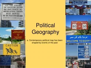
Political Geography . I. State and Nation. A. state: political unit (can be used interchangeably with country) B. nation: refers to a tightly knit group of people (usually having similarities: culture, language, religion, etc.) e.g. Yugoslavia is a state but not a nation.

E N D
I. State and Nation • A. state: political unit (can be used interchangeably with country) • B. nation: refers to a tightly knit group of people (usually having similarities: culture, language, religion, etc.) • e.g. Yugoslavia is a state but not a nation. • nationalism - loyalty to a nation/ sense of inclusion
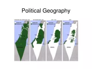
Stateless Nations - Have no national Territory • e.g. 1990 Palestinian Arabs • 6.5 million (Israel, Jordan, Lebanon, Syria) CIA Factbook. online
Kurdistan • 20 million Kurds • Turkey and Iraq very volatile relationship • Kurds desire territory or at least autonomous control of land in Iraq and Turkey Fellmann 343
Nation-State • Ideal built on homogeneity of territory and culture • Politically organized • Sovereignty: final authority over territories political and military affairs • Example - Japan • Ethnic Groups in Japan Japanese 99% Picture Here CIA Factbook. online
B. Territory Shape SAN MARINO CHILE VATICAN CITY ITALY URUGUAY THAILAND JAPAN
1. Compact State • Close to circular • Easiest to manage (most stable) and defend • The distance from any point of the country to its center is about the same. • e.g. Poland, Iceland, Democratic Republic of the Congo, Zimbabwe ZIMBABUE
2. Fragmented State • Territory is divided; some parts separated by water or another state. • Also known as archipelago states. • Difficult to govern because some may be composed of thousands of islands • e.g. Philippines, Indonesia, United States, Russia. THE PHILIPPINES
Hello down there! 3. Elongated • Long, “skinny” shape. • Can create separatist areas due to distance from center or core • Vietnam, Chile, Norway NORWAY
4. Prorupted States • Also known as “panhandle” state. • An area that extends from a compact area • Can create room for factions geographically • E.g.: Thailand, Burma BURMA
5. Perforated State • State that surrounds another state completely • Surrounded state (enclave) can only be reached by going through perforated state • E.g.: Italy, South Africa (only two recognized examples). SOUTH AFRICA
Enclave/Exclave • Exclaves: territories separated from the state by another state • e.g. Alaska (U.S.), Kaliningrad (Russia). • Azerbaijan has THREE exclaves inside Armenia. • Enclaves: territories whose entire boundaries are surrounded within the boundaries of another. • Lesotho, Vatican C = enclave of A, exclave of B C = exclave of B but NOT enclave of A; surrounded by both A and D
What Is a Boundary? • Boundary: a vertical plane that cuts through the airspace and ground to determine ownership
Problems with Boundaries • Lack of knowledge of underground resources when boundaries were created • 1990 Kuwait vs. Iraq: Rumaylah oil reserves • created International conflict (picture 349)
Who Controls Airspace? • When boundaries were created there was a lack of knowledge of importance of airspace • a. airline traffic • b. satellite space?
How are Boundaries Created? • Definition - usually legally by someone who is not directly involved (written) • Delimitation - mapped • Demarcation - marked with posts, walls, fences, etc. • Administration – determine how to maintain the boundary and how goods/people will cross it.
1. Geometric Boundary • Straight line boundary totally unrelated to physical features • Generally defined as a line of latitude or longitude • e.g. U.S./Canada (49N), many U.S. states
2. Physical/Political • AKA natural-political • Boundaries that conform to physical features • e.g. U.S./Mexico along the Rio Grande, Spain/France (Pyrenees), U.S./Canada (Great Lakes)
3. Historical/Genetic Boundaries A. Antecedent: Boundary created before present cultural landscape developed. 49th Parallel: Established as the northern border of the United States (with Canada) by treaty in 1846.
3. Historical/Genetic Boundaries B. Subsequent (ethnographic): Boundary created to accommodate existing cultural/economic differences between countries. Peace of Westphalia Created borders between European countries based on traditional homelands and culture.
3. Historical/Genetic Boundaries C. Superimposed:border that is forced upon a territory without consideration for a unified cultural landscape. Borders within were determined by European powers, which eventually created the modern borders. The borders have been a source of conflict within many countries, most notably Rwanda and Sudan.
3. Historical/Genetic Boundaries D. Relic (relict):Former boundary line that no longer serves as such, but imprint is still visible. East Side Gallery: Portion still standing of the Berlin Wall Hadrian’s Wall: Border of the Roman Empire in Britain. (122 CE)
4. Boundary Disputes A. Territorial/Definitional: Whose land is it? Dispute over legal language of the agreement. Kashmir Mountainous region disputed between India, Pakistan, and separatist movements. Under India’s control since 1947, when the leaders of Kashmir were given a choice to join either Pakistan or India. Majority of population is Muslim. Source of tension between the two countries.
4. Boundary Disputes B. Resource/Allocational Who gets to use these resources? • Examples: • Iraq/Kuwait (Ramallah oil field) • Saudi Arabia vs. Yemen (oil rich border not covered in the treaty)
IV. Boundary Disputes C. Functional/Operational How should the boundary function? United States/Mexico Dispute over immigration policy
Boundary Disputes • D. Allocational Border Dispute • 1. dispute over boundary due to location of resources • 2. water supplies - Colorado River nasa
Various boundary disputes - what type are they? • Botswana has built electric fences to stem the thousands of Zimbabweans who flee to find work and escape political persecution. Functional Source: http://www.cia.gov/cia/publications/factbook/fields/2070.html
Various boundary disputes - what type are they? • Eritrea and Ethiopia agreed to abide by 2002 Ethiopia-Eritrea Boundary Commission's (EEBC) delimitation decision, but despite international intervention, mutual animosities, accusations, and armed posturing have prevented demarcation • Ethiopia refuses to withdraw to the delimited boundary until claimed technical errors made by the EEBC that ignored "human geography" are addressed, including the award of Badme, the focus of the 1998-2000 war. Territorial and Positional Source: http://www.cia.gov/cia/publications/factbook/fields/2070.html
Various boundary disputes - what type are they? • All of the Spratly Islands are claimed by China, Taiwan, and Vietnam; parts of them are claimed by Malaysia and the Philippines; in March 2005, the national oil companies of China, the Philippines, and Vietnam signed a joint accord to conduct marine seismic activities in the Spratly Islands. Resource Source: http://www.cia.gov/cia/publications/factbook/fields/2070.html
Mari-time Boundaries • UN Convention on Law of the Sea Source: http://en.wikipedia.org/wiki/Image:Zonmar-en.svg