Download

1 / 74
740 likes | 744 Vues
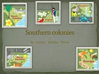
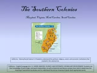
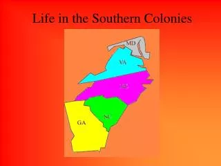
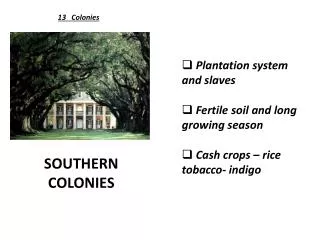
LEQ: What were the Southern Colonies?. The Southern Colonies included Virginia, Maryland, North Carolina, South Carolina, and Georgia. This image is courtesy of east-buc.k12.ia.us. LEQ: What were the Southern Colonies? Virginia, Maryland, North Carolina, South Carolina, Georgia.

E N D
LEQ:What were the Southern Colonies? The Southern Colonies included Virginia, Maryland, North Carolina, South Carolina, and Georgia. This image is courtesy of east-buc.k12.ia.us.
LEQ:What were the Southern Colonies?Virginia, Maryland, North Carolina, South Carolina, Georgia The Southern Colonies included Virginia, Maryland, North Carolina, South Carolina, and Georgia. This image is courtesy of east-buc.k12.ia.us.
The Southern Colonies Basics The Southern Colonies established by Great Britain in North America included Maryland, Virginia, North Carolina, South Carolina, and Georgia. This image is courtesy of englishcolonizationofna07.pbworks.com.
Southern ColoniesVocabulary This image is from wordinfo.info.
A guarantee that all Christians had the right to worship as they pleased. This image depicts Lord Baltimore (Cecil Calvert) issuing the Acts of Toleration to the citizens of Maryland. This painting by Tompkins Harrison Matteson (1813-1884) was created in 1853. This image is courtesy of msa.maryland.gov.
Toleration ActA guarantee that all Christians had the right to worship as they pleased. This image depicts Lord Baltimore (Cecil Calvert) issuing the Acts of Toleration to the citizens of Maryland. This painting by Tompkins Harrison Matteson (1813-1884) was created in 1853. This image is courtesy of msa.maryland.gov.
In Maryland, Protestants outnumbered Catholics. To protect both groups, Lord Baltimore issued the Toleration Act. The Toleration Act did not guarantee other religious groups such as Jews, the right to worship as they chose. The first settlers in the colony of Maryland erected a cross on St. Clement’s Island in what is now St. Mary’s County. This image by Francis Blackwell Mayer (1827-1899), titled “The Planting of the Colony of Maryland” was created in 1893. This image is courtesy of msa.maryland.gov.
Products of pine forests used in wooden shipbuilding and maintenance. Tar and pitch were largely used to paint the bottom of wooden British ships to seal the ships from water (keep it from leaking) and to prevent shipworms from damaging the hull.This image shows the British Royal Navy’s H.M.S. Victory, now in dry-dock in England. This image is courtesy of Wikimedia Commons.
Naval StoresProducts of pine forests used in wooden shipbuilding and maintenance. Tar and pitch were largely used to paint the bottom of wooden British ships to seal the ships from water (keep it from leaking) and to prevent shipworms from damaging the hull.This image shows the British Royal Navy’s H.M.S. Victory, now in dry-dock in England. This image is courtesy of Wikimedia Commons.
Naval stores includes products such as tar, pitch, and turpentine that are used in shipbuilding. This painting shows the construction of the ship Pilgrim. This image is courtesy of medfordhistorical.org.
A plant that produces a blue dye. Indigo is not native to North America. It is native to India. Europeans brought it to North America to attempt to compete with the Indian market. In 1773 over 1.1 million pounds were exported to England. This image is courtesy of clemson.edu.
IndigoA plant that produces a blue dye. Indigo is not native to North America. It is native to India. Europeans brought it to North America to attempt to compete with the Indian market. In 1773 over 1.1 million pounds were exported to England. This image is courtesy of clemson.edu.
In 1773 over 1.1 million pounds of indigo were exported to England. This image from the 1700s shows the different stages of indigo processing in South Carolina. This image is from “A Map of the Parish of St. Stephen,” by Henry Mouzon. This image is courtesy of the rare Book, Manuscript, and Special Collections Library at Duke University and of the University of North Florida.
Southern ColoniesPeople to Meet This painting shows the Yamacraw Creek Indians meeting with the Trustees of the colony of Georgia in July, 1734 in England. This image is courtesy of Wikimedia Commons.
He was granted a charter for the colony of Maryland and he was the creator of the Toleration Act which guaranteed freedom of worship to all Christians. Cecilius Calvert, the second Lord Baltimore (1605-1675) governed Maryland for 42 years from his home in North Yorkshire, England. This image by Florence MacKubin (1861-1918) was painted in 1910. It is courtesy of Wikimedia Commons.
Lord BaltimoreHe was granted a charter for the colony of Maryland and he was the creator of the Toleration Act which guaranteed freedom of worship to all Christians. Cecilius Calvert, the second Lord Baltimore (1605-1675) governed Maryland for 42 years from his home in North Yorkshire, England. This image by Florence MacKubin (1861-1918) was painted in 1910. It is courtesy of Wikimedia Commons.
He was the founder of the colony of Georgia which he had established for people to escape debtor’s prison. James Edward Oglethorpe (1696-1785) was a British general, and a member of the British Parliament. Oglethorpe chaired a Parliamentary committee on prison reform and documented terrible abuses in three debtors’ prisons. This image is courtesy of Wikimedia Commons.
James OglethorpeHe was the founder of the colony of Georgia which he had established for people to escape debtor’s prison. James Edward Oglethorpe (1696-1785) was a British general, and a member of the British Parliament. Oglethorpe chaired a Parliamentary committee on prison reform and documented terrible abuses in three debtors’ prisons. This image is courtesy of Wikimedia Commons.
King of Great Britain when the last of the 13 original English colonies was founded. The last colony was named after him. This painting of King George II (1683-1760) was created by Thomas Hudson (1701-1779) in 1744. The original hangs in London’s National Portrait Gallery. This image is courtesy of Wikimedia Commons.
King George IIKing of Great Britain when the last of the 13 original English colonies was founded. The last colony was named after him. This painting of King George II (1683-1760) was created by Thomas Hudson (1701-1779) in 1744. The original hangs in London’s National Portrait Gallery. This image is courtesy of Wikimedia Commons.
Southern ColoniesMaps The Southern Colonies included Virginia, Maryland, North Carolina, South Carolina, and Georgia. This image is courtesy of east-buc.k12.ia.us.
James River This image shows the 50 States of the United States. This image is courtesy of the University of Texas.
James River The James River is now colored blue. This image shows the 50 States of the United States. This image is courtesy of the University of Texas.
Potomac River This image shows the 50 States of the United States. This image is courtesy of the University of Texas.
Potomac River The Potomac River is now colored blue. This image shows the 50 States of the United States. This image is courtesy of the University of Texas.
Charles Town or Charleston, South CarolinaFind Charleston, South Carolina on this map of the current United States. This map shows the present boundaries of the states. The image is courtesy of the University of Texas.
Charles Town or Charleston, South CarolinaFind Charleston, South Carolina on this map of the current United States. Charleston, South Carolina is now marked by a red dot and the word “Charleston.” This map shows the present boundaries of the states. The image is courtesy of the University of Texas.
Virginia Before 1863Find Virginia on this map of the current United States. This map shows the present boundaries of the states. The image is courtesy of the University of Texas.
Virginia Before 1863Find Virginia on this map of the current United States. Virginia before 1863 is now colored red. During that time it included what is now the State of West Virginia. The image is courtesy of the University of Texas.
Virginia Find Virginia on this map of the current United States. This map shows the present boundaries of the states. The image is courtesy of the University of Texas.
Virginia Find Virginia on this map of the current United States. Virginia is now colored red. The image is courtesy of the University of Texas.
MarylandFind Maryland on this map of the current United States. This map shows the present boundaries of the states. The image is courtesy of the University of Texas.
MarylandFind Maryland on this map of the current United States. Maryland is now colored red. The image is courtesy of the University of Texas.
North Carolina Find North Carolina on this map of the current United States. This map shows the present boundaries of the states. The image is courtesy of the University of Texas.
North CarolinaFind North Carolina on this map of the current United States. North Carolina is now colored red. The image is courtesy of the University of Texas.
South CarolinaFind South Carolina on this map of the current United States. This map shows the present boundaries of the states. The image is courtesy of the University of Texas.
South CarolinaFind South Carolina on this map of the current United States. South Carolina is now colored red. The image is courtesy of the University of Texas.
GeorgiaFind Georgia on this map of the current United States. This map shows the present boundaries of the states. The image is courtesy of the University of Texas.
GeorgiaFind Georgia on this map of the current United States. Georgia is now colored red. The image is courtesy of the University of Texas.
LEQ:What were the Southern Colonies? The Southern Colonies included Virginia, Maryland, North Carolina, South Carolina, and Georgia. This image is courtesy of east-buc.k12.ia.us.
LEQ:What were the Southern Colonies?Virginia, Maryland, North Carolina, South Carolina, Georgia The Southern Colonies included Virginia, Maryland, North Carolina, South Carolina, and Georgia. This image is courtesy of east-buc.k12.ia.us.
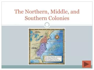
13 British colonies were located from New England to Georgia. This map shows the Thirteen British colonies. Maine, shown in red, was not one of the 13 original colonies. Maine was part of the colony of Massachusetts. This image is courtesy of socialstudiesforkids.com.
MassachusettsFind Massachusetts on this map of the 50 States of the United States. This image shows the 50 States of the United States. This image is courtesy of the University of Texas.
MassachusettsFind Massachusetts on this map of the 50 States of the United States. Massachusetts is now colored red. On February 6, 1788, Massachusetts became the 6th State. This image shows the 50 States of the United States. This image is courtesy of the University of Texas.
Rhode IslandFind Rhode Island on this map of the current United States. This map shows the present boundaries of the states. The image is courtesy of the University of Texas.
Rhode IslandFind Rhode Island on this map of the current United States. Rhode Island is now colored red. The image is courtesy of the University of Texas.
ConnecticutFind Connecticut on this map of the current United States. This map shows the present boundaries of the states. The image is courtesy of the University of Texas.
ConnecticutFind Connecticut on this map of the current United States. Connecticut is now colored red. The image is courtesy of the University of Texas.
New HampshireFind New Hampshire on this map of the current United States. This map shows the present boundaries of the states. The image is courtesy of the University of Texas.
New HampshireFind New Hampshire on this map of the current United States. New Hampshire is now colored red. The image is courtesy of the University of Texas.