Download
1 / 3
30 likes | 162 Vues
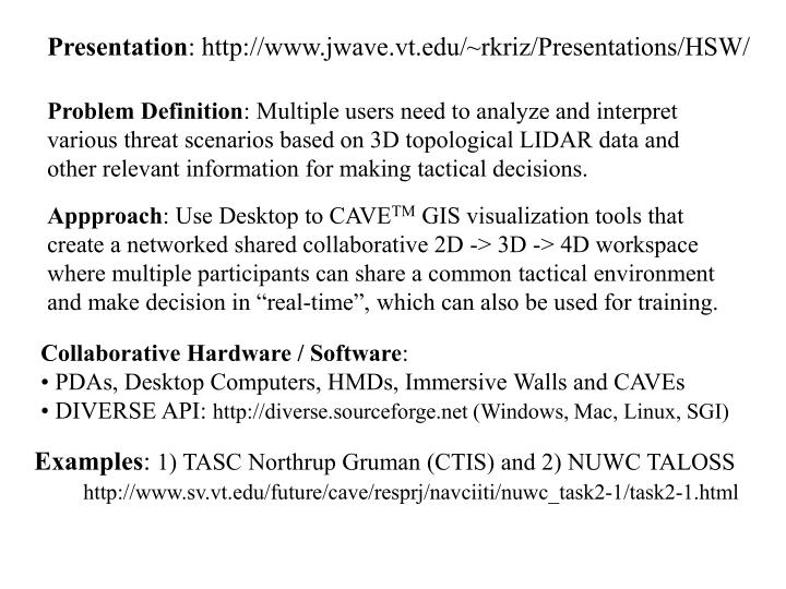
Presentation : http://www.jwave.vt.edu/~rkriz/Presentations/HSW/. Problem Definition : Multiple users need to analyze and interpret various threat scenarios based on 3D topological LIDAR data and other relevant information for making tactical decisions.

E N D
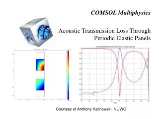
Presentation: http://www.jwave.vt.edu/~rkriz/Presentations/HSW/ Problem Definition: Multiple users need to analyze and interpret various threat scenarios based on 3D topological LIDAR data and other relevant information for making tactical decisions. Appproach: Use Desktop to CAVETM GIS visualization tools that create a networked shared collaborative 2D -> 3D -> 4D workspace where multiple participants can share a common tactical environment and make decision in “real-time”, which can also be used for training. • Collaborative Hardware / Software: • PDAs, Desktop Computers, HMDs, Immersive Walls and CAVEs • DIVERSE API: http://diverse.sourceforge.net (Windows, Mac, Linux, SGI) Examples: 1) TASC Northrup Gruman (CTIS) and 2) NUWC TALOSS http://www.sv.vt.edu/future/cave/resprj/navciiti/nuwc_task2-1/task2-1.html