Download
1 / 79
790 likes | 959 Vues
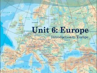
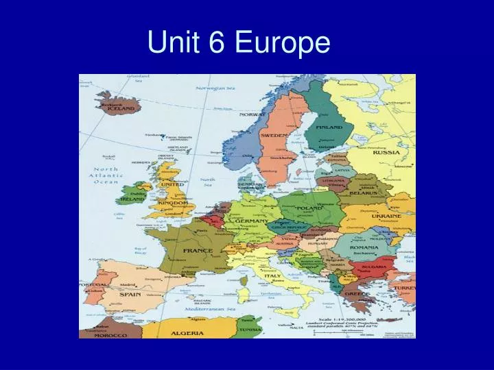
Unit 6 Europe. Satellite View. 3,800 square miles. Regions. Europe Population Density. Climate. Strait of Gibraltar. Separates Europe from Africa. Landmarks Strait of Gibraltar - separates Europe from Africa at the mouth of the Mediterranean Sea

E N D
Climate Strait of Gibraltar Separates Europe from Africa
Landmarks Strait of Gibraltar- separates Europe from Africa at the mouth of the Mediterranean Sea • Climates varied climate regions--everything from tundra to Mediterranean • Western & Northern Europe dominated by Marine West Coast, due to the prevailing westerly winds off the Atlantic Ocean • Eastern by Cool & Subarctic, • Southern by Mediterranean
North Atlantic Drift • Is a powerful warm ocean current that continues the Gulf Stream northeast. West of Ireland it splits in two; one branch, the Canary Current, goes south, while the other continues north along the coast of northwestern Europe.
Peninsulas and Islands • Europe is a large peninsula made of smaller ones. • Europe has islands in the North Atlantic and the Mediterranean Sea. All have depended on trade.
Northern Peninsulas: Scandinavian Jutland Southern Peninsulas: Iberian Italian Balkan European Peninsulas
Northern Peninsulas Scandinavian Peninsula Jutland Peninsula
Scandinavian Peninsula • Norway and Sweden
Jutland Peninsula • Denmark and a small part of Germany
Southern Peninsulas CrimeanPeninsula Iberian Peninsula Italian Peninsula Balkan Peninsula AnatoleanPeninsula
Iberian Peninsula • Spain and Portugal
Italian Peninsula • Italy
Balkan Peninsula • It is very mountainous and is surrounded by the Adriatic, Mediterranean, and Aegean Seas.
Larger Islands: Located in the North Atlantic. Great Britain Ireland Iceland Greenland Smaller islands: Located in the Mediterranean Sea. Corsica Sardinia Sicily Crete European Islands
Mediterranean Sea: Strait of Gibraltar & the“Pillars of Hercules” 2,400 miles long & 1,000 miles wide “Crossroads of 3 Continents” Strait of Gibraltar- separates Europe from Africa at the mouth of the Mediterranean Sea
Mountains • Mountains and uplands have made movement of people, goods, and ideas more difficult. They also affect the weather.
The Alps Cover most of Switzerland, Austria, and parts of Italy and France. *Innovations in transportation and technology have made the alps much less of a barrier to travel and trade
Mt. Blanc in the Alps Highest mountain in the Alps: 15,771 feet
The Pyrenees Mountains • Restrict movement from France to Spain and Portugal.
The Apennine Mountains • Divide the Italian Peninsula between east and west.
The Balkan Mountains • Blocks off the Balkan Peninsula from the rest of Europe. • Historically, have isolated the peninsula’s ethnic groups from each other.
Uplands • Uplands are hills or low mountains that may contain mesas or high plateaus.
The Meseta • Spain’s central plateau, this an upland region.
Massif Central • French uplands.
Rivers: Europe’s Link • The two major rivers are the Danube and the Rhine. • They are or were used for transportation, power, and trade.
Rivers Po R. Tiber R.
The Danube River 1770 miles
The Danube River Flows through the12 countriesof Germany, Austria, Slovakia, Hungary, Serbia, Croatia, Bosnia and Herzegovina, Slovenia, Bulgaria, Romania, and the Ukraine.
Fertile Plains • The most important plain in Europe is the Northern European Plain. • It produces a lot of food but is also an avenue for invasion. • Europe has an abundance of coal and iron ore and those resources are essential for making steel. • The Irish burn peat because they lack other kinds of energy resources. • Peat – is partially decayed plant matter found in bogs (is a wetland).
Dikes • *The Dutch needed land reclaimed from the Sea. To do this they built Dikes, earthen banks to hold back the sea.
Polder • *The Dutch then drained the water off the land. The land that is reclaimed by dikes and drainage is a polder.
Zuider Zee • An arm of the North Sea that the Dutch transformed into a freshwater lake.
Ijsselmeer • Name of the freshwater lake created by the Zuider Zee.
Waterways for Commerce • Water transportation is important in Venice because the city is made up of islands and canals. • Venice grew because it is a good location for trade. • Problems Venice faces are pollution, flooding, algae, and it is sinking.
Water Pollution • Mines and factories create much of Europe’s water pollution. • Sewage contaminates rivers and many cities do not have treatment plants. • Oil spills spread and kill wildlife. • *Spain built Europe’s first desalination plant.
Cleaning Up the Water • Because water pollution spreads so easily, nations must cooperate to solve the problem. • The EU also set up the European Environmental Agency, which provides the EU with reliable information about the environment.
Deforestation • One fourth of Europe is affected by acid rain. • Acid rain is produced when sulfur emissions from factories combine with water vapor. • Clearing of forest for fuel and building and industrial pollution have all led to deforestation.
Agricultural Pollution • Chemical fertilizers cause algae and plants to grow faster than fish can eat them. Plants and algae die, a process that uses up oxygen. • Agricultural pesticides can harm wildlife, contaminate water, and kill beneficial insects.
Air Quality • Air pollution is made up of harmful gases and particulates, very small particles of liquid or solid matter. • Using fossil fuels causes much air pollution. • Other causes are fires, chemical use, and industry.