Download
1 / 10
100 likes | 625 Vues
Map Scale, Proportion and Google earth. Alyson Dougherty. NCTM Standards. Make decisions about units and scales that are appropriate for problem situations involving measurement Understand and use ratios and proportions to represent quantitative relationships

E N D
Map Scale, Proportion and Google earth • Alyson Dougherty
NCTM Standards • Make decisions about units and scales that are appropriate for problem situations involving measurement • Understand and use ratios and proportions to represent quantitative relationships • Develop, analyze, and explain methods for solving problems involving proportions, such as scaling and finding equivalent ratios
Summary • Aerial imagery was utilized through Google Earth to relate proportions to students in an Algebra 1/ Data Analysis class. • Constructivist approach to understanding map scale and proportional reasoning • Use of familiar surroundings and major landmarks to relate to students and engage their fascination with satellite imagery
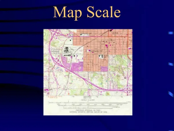
Five aerial photographs of varying map scale of the school and surrounding streets, student discussion about size and teacher scaffolding to introduce scale • Football field as common measurement basis in representative fraction • Conversion to a unit fraction, numerator equal to 1 =
Extending Map Scale to Create Proportions • Ground distance was expressed as an unknown variable, x • Students came up with 2 ways • map scale= (image length)/(ground distance) =
World Imagery Challenge • Series of 19 aerial photographs of famous places (Taj Mahal, Eiffel Tower) from Google Earth printed using a variety of scales. • Students had to recognize location and make map scale calculations
Strengths • Engaging activity that builds on itself • Don’t have to be in a computer lab to complete • Integrates technology, making it a differentiated lesson • Relates real life application to the classroom • Having posters hung in a hallway addresses the preferred learning style for kinesthetic learners • Application of “doing math” with high level Bloom’s objectives
Weakness • In hopes of including this activity in my 8th grade classroom at Bristol Central, this activity is too time consuming. I think it’d be great for a regular school year activity where a couple class periods can be spent investigating. • Key to have a football field or other standard measurable landmark in the image to create the initial benchmark measurement. Picking a part of New York City or a rural area without a football field reduces the inductive reasoning required by students.
Discussion Questions • Are there any other adaptations you can think of to make this more interactive? • How do you think it would work to include distance, rate and time in for traveling on some of the roads? Do you think that would be too cumbersome and/or boring for students? • Is Google really going to take over the world?
Bibliography • Map Scale, Proportion, and Google Earth by Martin C. Roberge and Linda C. Cooper in Mathematics Teaching in Middle School Vol 15, No.8, April 2010