Download
1 / 24
240 likes | 390 Vues
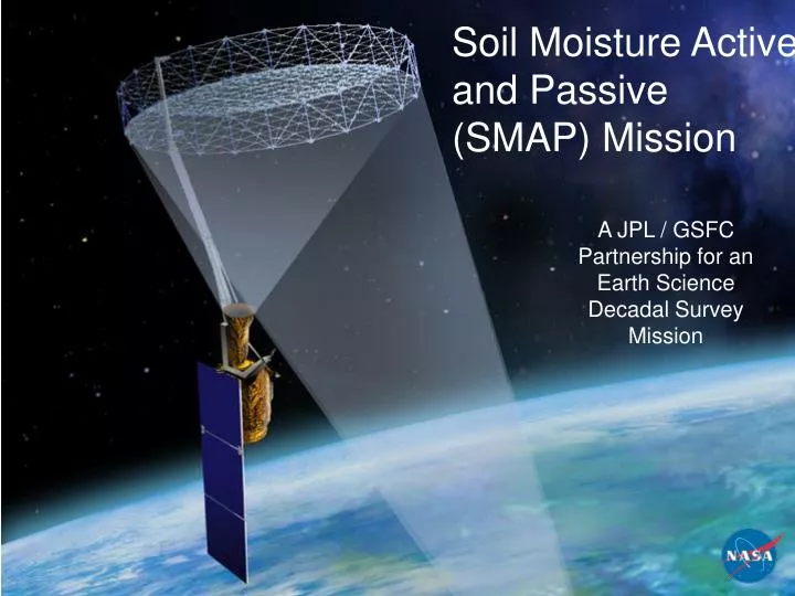
Soil Moisture Active and Passive (SMAP) Mission. A JPL / GSFC Partnership for an Earth Science Decadal Survey Mission. Outline. SMAP science – why do we care about soil moisture & FT NRC Decadal Survey impetus SMAP science objectives Mission & instrument concept

E N D
Soil Moisture Active and Passive (SMAP) Mission A JPL / GSFC Partnership for an Earth Science Decadal Survey Mission
Outline • SMAP science – why do we care about soil moisture & FT • NRC Decadal Survey impetus • SMAP science objectives • Mission & instrument concept • SMAP science products & synergy
Dry Soil 5°C Moist Soil Soil Moisture Controls Land / Atmosphere Interactions • Soil moisture is an important land surface control on water and energy fluxes. • A soil moisture mission will help answer: • -- do climate models correctly represent land • surface / atmosphere interactions? • -- what are the water resources and water • availability impacts of global climate change? Impact on Atmosphere May 10 : Clear w/ scattered cirrus & mild winds May 18: 90 mm Rain May 20: Clear sky & mild winds Water and Energy Cycle (Cahill et al., 1999) CASES’97, BAMS (81), 2000.
Value of Soil Moisture Data to Weather and Climate New space-based soil moisture observations and data assimilation modeling can improve forecasts of local storms and seasonal climate anomalies NWP Rainfall Prediction Seasonal Climate Predictability Predictability of seasonal climate is dependent on boundary conditions such as sea surface temperature (SST) and soil moisture – soil moisture is particularly important over continental interiors. Difference in Summer Rainfall: 1993 (flood) minus 1988 (drought) years Buffalo Creek Basin Observed Rainfall 0000Z to 0400Z 13/7/96 (Chen et al., 2001) Without Realistic Soil Moisture Observations 24-Hours Ahead High-Resolution Atmospheric Model Forecasts Simulation driven by SST and soil moisture Simulation driven just by SST With Realistic Soil Moisture High resolution soil moisture data will improve numerical weather prediction (NWP) over continents by accurately initializing land surface states (Schubert et al., 2002) -5 0 +5 Rainfall Difference [mm/day]
Terrestrial Water, Energy and Carbon Cycle Processes SMAP will provide important information on the land surface processes that control land-atmosphere carbon source/sink dynamics. It will provide more than 8-fold increase in spatial resolution over existing spaceborne sensors. Carbon Cycle Landscape Freeze/Thaw Dynamics Drive Boreal Carbon Balance [The Missing Carbon Sink Problem]. Are Northern Land Masses Sources or Sinks for Atmospheric Carbon? Mean growing season onset for 1988 – 2002 derived from coarse resolution SSM/I data
Current Operational Drought Indices by NOAA and National Drought Mitigation Center (NDMC) Current NWS Operational Flash Flood Guidance (FFG) Flood and Drought Applications “…delivery of flash-flood guidance to weather forecast offices are centrally dependent on the availability of soil moisture estimates and observations.” “SMAP will provide realistic and reliable soil moisture observations that will potentially open a new era in drought monitoring and decision-support.” Decadal Survey: Current: Empirical Soil Moisture Indices Based on Rainfall and Air Temperature ( By Counties or ~30 km ) SMAP Capability: Direct Soil Moisture Observations – global, 2-3 day revisit, 10 km resolution
NRC SMAP Expectations “…the SMAP mission is ready for “fast-track” towards launch as early as 2013, when there are few scheduled Earth missions. The readiness of the SMAP mission also enables gap-filling observations to meet key NPOESS community needs (soil moisture is “Key Parameter,” see 4.1.6.1.6 in IORD-II Document).” SMAP is one of four missions recommended by the NRC Earth Science Decadal Survey for launch in the 2010-2013 time frame
NASA SMAP Workshop (July 2007) Key Workshop Conclusions(Executive Summary): • There is a stable set of instrument measurement requirements for SMAP that are traceable to science requirements for soil moisture and freeze/thaw. • The baseline SMAP instrument design is capable of satisfying the science measurement requirements. • Significant heritage exits from design and risk-reduction work performed during Hydrosphere State (Hydros) mission formulation and other technology development activities. • Heritage and lessons learned can be leveraged from the Aquarius project. This heritage includes both the L-Band radiometer and radar electronics. • • There are no technology “show-stoppers”, and SMAP formulation is positioned to begin where Hydros left off. http://hydrology.jpl.nasa.gov/missions/SMAP/
SMAP Science Objectives • Global mapping of Soil Moisture and Freeze/Thaw state to: • Understand processes that link the terrestrial water, energy & carbon cycles • Estimate global water and energy fluxes at the land surface • Quantify net carbon flux in boreal landscapes • Enhance weather and climate forecast skill • Develop improved flood prediction and drought monitoring capability Primary Controls on Land Evaporation and Biosphere Primary Productivity Freeze/ Thaw Soil Moisture Radiation
SMAP Mission Concept • Orbit: • Sun-synchronous, 6 am/pm orbit • 670 km altitude • Instruments: • L-band (1.26 GHz) radar • High resolution, moderate accuracy soil moisture • Freeze/thaw state detection • SAR mode: 3 km resolution • Real-aperture mode: 30 x 6 km resolution • L-band (1.4 GHz) radiometer • Moderate resolution, high accuracy soil moisture • 40 km resolution • Shared instrument antenna • 6-m diameter deployable mesh antenna • Conical scan at 14.6 rpm • incidence angle: 40 degrees • Creates contiguous 1000 km swath • Swath and orbit enable 2-3 day revisit • Mission Development Schedule • Phase A start: September 2008 • SRR/MDR: February 2009 • PDR: December 2009 • CDR: December 2010 • SIR: October 2011 • Instrument Delivery April 2012 • LRD: March 2013 • Mission operations duration: 3 years
Mission Implementation Approach • Mission partners: JPL and GSFC • Potential non-NASA partnerships • Leverage knowledge from Hydros studies • Science Team selected competitively by NASA • Radar provided by JPL • Radiometer provided by GSFC • Maximize Aquarius heritage • Shared antenna and spin assembly procured from industry • Instrument data processing shared between JPL and GSFC • Spacecraft developed in-house at JPL • Launch vehicle: Minotaur IV based on DoD use of SMAP data
SMAP Instrument Concept • Radiometer measurements: • 40 km real-aperture resolution • Made over 360 deg of scan • Form full contiguous swath of 1000 km • Collected continuously; AM/PM, over land and over ocean • “Low res” radar measurements: • 30 x 6 km real-aperture “slices” • Made over forward and aft portions of scan • Form full contiguous swath of 1000 km • Collected continuously, AM/PM, over land and over ocean • “High res” radar measurements: • Used to generate 1 km gridded product, can be further averaged up to 3 km and 10 km. • Made over forward 180 deg of scan only (optional 360 deg collection possible) • 1000 km swath with nadir gap of 200-300 km astride spacecraft ground track • Collection programmable; baseline to collect over land during AM portion of orbit only • Orbit:670 km, sun-synchronous, 6 pm LTAN • Instrument Architecture:Radiometer and radar share rotating 6 meter diameter reflector antenna • Antenna Beam:14.6 rpm rotation rate, 40 deg incidence angle 1000 km Nadir gap in high res radar data: 200-300 km
SMAP Coverage Strategy Radiometer, Low-Res Radar High-Res Radar • Three orbit sample shown in image above. • Low-res radiometer and low-res radar: Using AM revs only, cover entire Earth in 3-days. Average revisit time improves when AM + PM passes are used (but Faraday rotation becomes an issue). • High-res radar data collection is programmable via ground command. Average revisit time is 3-days over land when only AM revs are used.
Key antenna requirements Dual-pol L-Band feed < 2.6 deg BW at 1.4 GHz, >90% beam efficiency. 14.6 rpm rotation rate Deployable mesh material, high reflectivity at L-Band Pointing: 0.3º stability, 0.1º knowledge Rotational Inertia < 150 kg-m^2, CG to 2.5 cm, Inertia Cross Products < 1%, Stiffness > 1 Hz. During Hydros risk reduction, two antenna vendors were funded to study adaptations of heritage reflector designs for rotation. “Radial Rib” design with fixed central boom and rotating reflector. “Perimeter Truss” design with rotating reflector and boom. SMAP antenna RFP will have a requirement of no boom blockage Rotating Reflector
Level 1 Baseline and Minimum Requirements * Excludes forests (regions with vegetation water content greater than ~5 kg/m2) and urban / mountainous areas
Science L1 Requirements Baseline Mission Duration Requirement is 3 Years (Decadal Survey) (1)North of 45°N latitude
Baseline Science Data Products Global Mapping L-Band Radar and Radiometer High-Resolution and Frequent-Revisit Science Data Observations + Models = Value-Added Science Data
SMAP Mission Uniqueness Day SMOS SMAPRadar-Radiometer Climate Applications Aquarius Weather Applications Resolved Temporal Scales Week Evolution of L-Band Sensing Carbon Cycle Applications Radiometer Radar Month ALOSSAR 100 km 10 km 1 km Resolved Spatial Scales
SMAP Synergy With Other Missions/Applications Estimated Mission Timeline • SMAP provides continuity for L-band measurements of ALOS, SMOS, and Aquarius, and synergy with GPM and GCOM-W • SMAP soil moisture and co-orbiting GPM precipitation data will improve surface flux estimates and flood forecasts (Crow et al., 2006) • SMAP also benefits GPM by providing surface emissivity information for improved precipitation retrievals SMAP GPM GCOM-W Aquarius SMOS ALOS Potential reduction in GPM-estimated latent heat flux error by assimilation of SMAP soil moisture in land surface model (LDAS) RMS Error in Latent Heat Flux [W m-2] SMAP 3-day sampling Frequency of Rainfall Observations [day-1]
Examples of Combined L-Band Sensor Systems Aircraft-Based Tower-Based
SMAP Major Field Campaigns • SMAPVEX08 • High priority design/algorithm issues • Australia 2009-2010 • 4 one-week campaigns to span four seasons • J. Walker aircraft radiometer (PLMR) and new radar (PLIS) • Separate SMOS validation • SMAP SDT participation • Germany/Spain 2009-2010 • SMOS validation…launch delays possible • Can we get a European group to add L-band radar (DLR)? • SMAP SDT participation • SMAPVEX10: CLASIC • Spring-Summer 2010 • Oklahoma • SMOS and Aquarius available • Focus of algorithm validation • SMAPVEX11 • Focus on different problems: F/T, regions, seasons • SMAPVEX13 and 14 • SMAP product validation Satellite Launch in Red
Applications and User Engagement • By providing direct measurements of soil moisture and freeze/thaw state, SMAP will enable a variety of societal benefits: • Near-term SMAP applications outreach will be focused on: • 1. Developing a community of end-users, stakeholders, and decision makers that understand SMAP capabilities and are interested in using SMAP products in their application (SMAP Community of Practice). • 2. Developing an assessment of current application benefits / requirements and needs for • SMAP products (survey). • 3. Identifying a handful of “early adopters” who will partner to optimize their use of • SMAP products, possibly even before launch as part of the extended OSSE activities • (“targeted partners”). • 4. Providing information about SMAP to the broad user community Droughts Floods/Landslides Agriculture Weather/Climate Human Health
Project Overview SMAP is a first-tier mission recommended by 2007 NRC Earth Science Decadal Survey Primary Science Objectives • Global, high-resolution mapping of soil moisture and its freeze/thaw state to: • Link terrestrial water, energy and carboncycle processes • Estimate global water and energy fluxes at the land surface • Quantify net carbon flux in boreal landscapes • Extend weather and climate forecast skill • Develop improved flood and drought prediction capability Mission Implementation: http://smap.jpl.nasa.gov/