Download
1 / 10
100 likes | 899 Vues
UK National Travel Survey GPS Feasibility Study GPS Equipment Review / Pretest. Michelle Lee, GISP Jean Wolf, PhD GeoStats LP Atlanta, GA TRB Conference January 2010. Background of Feasibility Study.

E N D
UK National Travel SurveyGPS Feasibility StudyGPS Equipment Review / Pretest Michelle Lee, GISP Jean Wolf, PhD GeoStats LP Atlanta, GA TRB Conference January 2010
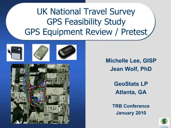
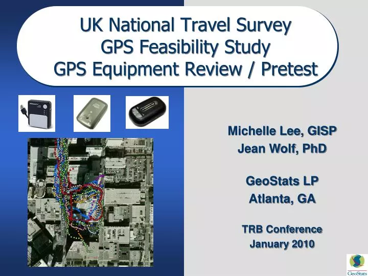
Background of Feasibility Study National Centre for Social Research (NatCen) is contracted by the Department for Transport (DfT) to conduct the UK National Travel Survey • Continuous survey (~ 8000-10,000 households each year) • One week diary, with short walk trips reported day 7 only The DfT has been interested in the possibility of using GPS in their NTS and asked NatCen to perform a feasibility study The feasibility study was conducted in 2008-2009 and included: • Technology assessment of commercially available GPS data loggers • A pretest of the best devices by NatCen and the DfT • A pilot study of 100 households using the selected device in tandem with the one week travel diary to compare GPS detected and diary reported trips
Task One: Technology Assessment Task One: Identify portable (i.e., wearable) GPS data logging devices commercially available in January 2008 and assess the suitability of these devices based on the project requirements, which included: • Form factor, size and weight – the device should be relatively unobtrusive or else respondents may be reluctant to carry them around • Battery life – the battery should support data collection for at least one day of travel activity without recharging to avoid data loss • Ease of recharging • Memory capacity – the memory must be capable of storing the data for the full period • Cost – including any additional costs for chargers, cases etc. • Ease of Use • Ease of device configuration data download • Required data elements captured – latitude, longitude, time, date, and speed • Data quality – output data should be of high quality with regard to coverage area and horizontal positional accuracy
GPS Requirements After an extensive internet and vendor-based search, GeoStats identified 32 wearable GPS logging devices available on the market. During the initial evaluation, all GPS data logging devices found whose specifications did not meet a minimum memory capacity, battery life, and the ability to download data via a USB connection were eliminated. Consequently, this elimination process resulted in the selection and purchase of nine devices for further evaluation. • Atmel BTT08 Data Logger • EverMore BT-900 • GiSTEQPhotoTrackr • GlobalSat DG-100 Data Logger • i-Blue 747 Data Logger • i-Blue 821 Slim Trip Recorder • Pharos Trips & Pics with GPS • Qstarz BT-Q1000P • Wintec WBT-201 Data Logger
Test Plan Overview To evaluate the performance and suitability of the nine devices selected, GeoStats defined twelve tests broken into three test phases. At the end of each phase, some devices were eliminated based on that phase’s results. Those devices remaining after a given phase of testing were then tested in the next phase. Phase 1 TEST ONE: Document data fields captured by each GPS device TEST TWO: Evaluate ease of use, form factor, and durability Eliminate any devices that should not be further tested Phase 2 TEST THREE: Evaluate cold start acquisition time TEST FOUR: Compare GPS traces versus accuracy of road network TEST FIVE: Compare GPS traces between different manufacturers TEST SIX: Compare GPS traces between the same manufacturers (when possible) TEST SEVEN: Evaluate GPS performance in urban canyon environment Eliminate any devices that should not be further tested Phase 3 TEST EIGHT: Test battery life TEST NINE: Test memory capacity TEST TEN: Test volatile or non-volatile memory TEST ELEVEN: Check vibrations sensor effectiveness – if applicable TEST TWELVE: Check speed screen accuracy Select top three devices for DfT / NatCen pretest
Results: Selected Devices for Pretest GeoStats recommended that the Atmel BTT08, the GlobalSat DG-100 and iBlue 747 continue into the pretest phase of the study • The Atmel and GlobalSat have been successfully deployed in numerous wearable GPS studies with reported success. • When properly configured, the point capacity, battery life and positional accuracy of all three devices exceeded the requirements for the UK NTS GPS Feasibility Study. • It was believed that each device met the form factor requirement for this study. Remaining concerns: • Atmel: voice feature could cause participants to not carry that device, flashing lights could also be deterent from use • iBlue 747: the “LOG” / “NAV” switch on the iBlue 747 could result in accidental data loss • GlobalSat: slightly larger size could be an issue
Pretest Overview • The top three GPS devices identified in the Task One Technology Assessment were the Atmel BTT08, the GlobalSat DG-100 and the iBlue 747. • The testing was completed in two rounds with the first round conducted in a similar manner to a typical household travel survey, and the second conducted with some head to head tests. • Employee volunteers from the DfT and NatCen carried the devices and fill out a simple travel diary including mode of transport. • Overall there were 31 GPS files collected during the pretest and compared to the reported travel diary data.
Pretest Results Overview • Atmel – Technology / Data Processing • Performed well with recommended settings • Software issues with configuration • Vibration sensor helpful for point reduction • ‘Wavy’ traces on some files • Atmel – Form Factor • Small Size / Lanyard versus Clip • Audible Voice Feature • Flashing Lights • GlobalSat – Technology / Data Processing • Performed well, easy to configure • Data easily processed • GlobalSat – Form Factor • Heavier and larger than the Atmel or iBlue • iBlue – Technology / Data Processing • Unable to hold speed screen configuration setting • iBlue – Form Factor • Switch on side (power / log / navigation) easy to move
Thank You • NatCen and DfT • New Technology Subcommittee Study Report to be released by DfT this winter