Download
1 / 23
270 likes | 523 Vues
KIRIBATI MARITIME BOUNDARIES & EXTENDED CONTINENTAL SHELF CLAIM. GIS CONFERENCE 2013. Romano Reo. Presentation Contents. Showcase where Kiribati is in relation to its Maritime Boundaries Kiribati Extended Continental Shelf claim. Kiribati Maritime Boundaries. Data Conversion.

E N D
KIRIBATI MARITIME BOUNDARIES & EXTENDED CONTINENTAL SHELF CLAIM GIS CONFERENCE 2013 Romano Reo
Presentation Contents • Showcase where Kiribati is in relation to its Maritime Boundaries • Kiribati Extended Continental Shelf claim
Kiribati Maritime Boundaries • Data Conversion • RevisedMarine Zone Act • Maps on Local Datum • Very outdated Hydro Chart • Geo-referenced using GPS ground truth
Kiribati Maritime Boundaries • Quality of existing charts can often be inadequate and not necessarily compatible with modern geodetic reference systems
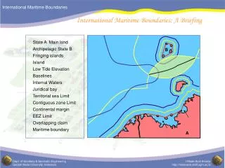
Kiribati – Shared Maritime Boundaries Marshall Islands Palmyra (US) Howland (US) Nauru Gilbert Islands Jarvis (US) Line Islands Phoenix Islands Tuvalu Tokelau (NZ) Cook Islands French Polynesia
Kiribati – completed all of its nine (9) maritime boundaries 1 2 3 4
Kiribati – completed all of its nine (9) maritime boundaries 9 8 7 6 5
Kiribati – completed all of its nine (9) maritime boundaries 1 9 8 4 2 3 5 7 6
Outstanding tasks • Update the Legislation – declaring outer limits in the domestic declarations • Lodge all the information with the United Nations
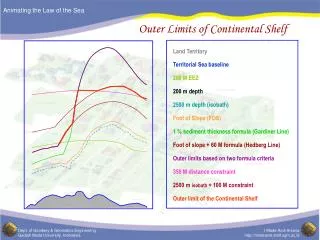
Kiribati Extended Continental Shelf Claim • Kiribati satisfies the provision of UNCLOS to claim ECS • Provides Kiribati with sovereign rights over the seabed beyond its Exclusive Economic Zone • 4 potential sites has been identified • Kiribati ECS claim been submitted to DOALOS on 24 December 2012, followed by presentation to the Commission in August 2013
Data Type & Applications Used • Singlebeam bathymetry • Multibeam bathymetry • Satellite derived gravity • ArcGIS • Geocap
Eastern Platform Western Platform Central Area BOS BOS Fingers Ridge Platform
Kiribati – ECS Claim Areas Gilbert Islands Phoenix Islands Line Islands
Submission contents • Executive Summary • Main Body • Supporting scientific and technical data
Kiribati – Total Marine Jurisdiction Total EEZ Area = 3.456M SQ.KM Total ECS Area = 110,000 SQ.KM Gilbert Islands Phoenix Islands Line Islands
TeMauri, TeRaoi, aoTeTabomoa THANK YOU