Download
1 / 35
350 likes | 567 Vues
Microtopographic Evidence of Human-Landscape Interactions in Knoydart Peninsula, Scotland, UK. Cynthia A. Stiles and Gordon Robertson University of Wisconsin - Madison. Why does western Scotland look like this?. And not like this?. Cape Fanshaw, SE Alaska.

E N D
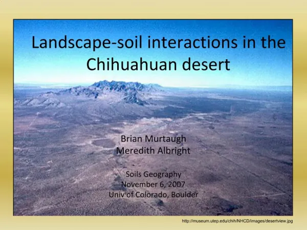
Microtopographic Evidence of Human-Landscape Interactions in Knoydart Peninsula, Scotland, UK Cynthia A. Stiles and Gordon Robertson University of Wisconsin - Madison
And not like this? Cape Fanshaw, SE Alaska
The landscape of northwestern Europe is remarkably dissimilar to equivalent settings in North America, even in areas that are only sparsely populated at present. The coastal reaches of southeastern Alaska in North America have steep slopes of metamorphic rock bounding a relatively warm sea and covered with nearly impenetrable native forests – the rare and majestic boreal rainforest. The Western Highlands of Scotland, the Palearctic equivalent of coastal Alaska, are covered with meadows of grasses, heaths, and mosses. Despite similarities of environmental conditions, e.g., bedrock parent material, climatic conditions, topography, and even glacial history, the Caledonian forests of Scotland are a distant memory, altered by the long-term influence of human beings.
The human factor - field systems Relict field system and abandoned farmstead
Scotland has been settled since the recession of the glaciers (late Mesolithic, 11 ka BP). Sparse evidence exists prior to the Iron Age of organized agriculture until the onset of the Viking invasions from AD 900-1100. The field systems shown in the previous slide are typical of the landscape throughout the Western Highlands and indeed throughout much of northwestern Europe. They are ubiquitous and are often very extensive on slopes considered unsuitable by present day U.S. standards for any type of cultivation farming. The systems of management include multiple tiers of fields, often segregated by turf fences (dikes) and rock walls. Garden-type agriculture was paired in rotation with domesticated animal grazing to best utilize the manure as fertilizer for the fields.
Hypotheses: • Long-term pre-industrial land management practices have left an imprint on the soils of Knoydart • These imprints have and continue to influence the existing vegetation mosaics and may actually hinder the restoration of natural plant communities • Soil physical and biogeochemical properties indicate relative impact of the imprints and function as ecological trajectory predictors
Research approach • Identify an area with field systems that have not been extensively disturbed during historic times • Utilize a ‘learning set’ of fields representative of the area and develop a correlative feature model to spatially assess and map the field systems with remotely sensed information such as aerial photos, etc. • Physical and biogeochemical assessment of soil within field systems and environmental “end members” (ancient forest, active fields) to determine the effect of long-term amendment inputs and assess present nutrient pools
In North America, we are unfamiliar with such long-term effects of agriculture as were experienced in Europe. But the intensity of our agriculture has left an indelible signature on our land. How long does it take for an altered system to go back to it’s pre-existing ecology, or does it ever go back to its native state? To this end, it is of great interest to investigate field areas that are “recovering” from agricultural pressures. The Western Highland District of Scotland provides an excellent place to investigate field systems left relatively undisturbed for several generations. Largely cleared of farmers after a rebellion against the crown in mid-1700’s, the Highlands have many fields that are still evident on the landscape and easily accessible to researchers. We found that the Knoydart Peninsula of western Scotland suited the goals of our research efforts quite well.
Location of study:Knoydart Peninsula Western HighlandsScotland, UK
The environmental landscape of Knoydart (1) • Knoydart is relatively small (220 km2) and isolated. There are no roads connecting the peninsula to other portions of Scotland. There are about 400 full-time residents and nearly half of the peninsula is designated as public trust and active forest restoration areas. • The bedrock from which the soils are forming is psammitic granulites and mica schists. Glaciation was restricted to the higher elevations and the loch channels. The metamorphic rock generally yields very nutrient poor soils. • Knoydart is known for its remoteness, scenery and steep topography. By modern standards, only 15% of the area of Knoydart is considered suitable for farming by U.S. standards (<20% slope). The uplands are bedrock controlled and the slopes are mainly colluvial deposits derived from native rock.
The environmental landscape of Knoydart (2) • On Knoydart, the mean annual precipitation ranges from 180-220 cm, falling evenly throughout the year. There is rarely a time when the ground is not saturated. The mean annual air temperature is 7°C and does not vary greatly from season to season, owing to the ameliorating influence of the relatively warm ocean currents. This mild and wet climate is classified as perudic isofrigid in the U.S. Soil Taxonomy system. • The present day vegetation is meadow dominated by cool-season turf grasses , blanket mire, heather/heath and bracken. There are few trees except in active restoration areas, probably because the young trees cannot compete with the meadow grasses or tolerate the pressure of grazing by wildlife (red deer) and sheep.
Human History of Knoydart • Settled since the Mesolithic • Farmed using subsistence methods – grazing commons • Depopulated – by British sympathists over 150 yrs ago • Recovery – pasturage for sheep and deer • Restoration – the Caledonian forest efforts Morrison, 1764 http://champlain.geography.wisc.edu/~grobertson/
The cultural landscape of Knoydart Knoydart has been populated since the retreat of the glaciers. What we know of Knoydart’s history largely comes from the Glenelg parish records. There are punctuated episodes of cultural significance through its history. The land was held by clan chiefs and landlords and tenant crofters of Knoydart utilized their natural resources intensively. The population reached a high of nearly 2000 people prior to the Jacobite rebellions in the mid- 1700’s. Once the rebellions were quelled, the lands were handed over to parties favoring the winning side and the majority of tenants given passage to Ireland or to North America. Most buildings were destroyed and the farmed fields turned over to grazing of large sheep herds. Eventually the sheep were deemed unprofitable and most of Knoydart has been left to recover naturally over the past century.
The agrarian systems on Knoydart Most important to our research are general agricultural practices of Knoydart, which consisted of combined grazing and intense garden-style farming. Lying within the Scottish “rough bounds”, life was hard fought and sustained. The landscape was largely cleared of trees during medieval times, when the wood was exported by the landowners or used for structures by the local population. Tools for farming were often community-owned. The methods of farming remind us today of what is known as “raised bed gardening” and fields were comprised of sets of constructed beds 0.5-1 m high to promote drainage and warm the soil. Amendments such as manure, fish offal, shell sand, and sea weed were valuable resources for enhancing the nutrient reservoir of the soil. This influx of nutrients over long periods of time have changed the ecological trajectory.
How do we recognize field systems?Developing a mapping “learning set” To assess the extent of field systems on Knoydart, we first established a “learning set” to teach digital imaging software to recognize remotely sensed fields. We identified fields on the ground, then assessed morphometry in relationship to landscape parameters. Our first system was located on the north coast of Morar, adjacent to Knoydart. We used this location because it is well-defined and shows some interesting relationships with the landscape very similar to fields on the coast of Knoydart. Once we taught ourselves what to look for and where on the landscape fields most likely occurred, we found they were ubiquitous along the coastal reaches in this part of Scotland and we’ve since had success in using false-color imagery to locate fields.
Recognizing field systems in the landscape Creag Iasgach field system, direct front view
Recognizing field systems in the landscape Field system at Creag Iasgach – NE oblique view
Field systems on the landscape Field systems on Knoydart and adjacent coastal areas generally occur in areas with easy access to sea, so that amendment materials can be transported by boat. The micromorphometry of the field systems changes with topographic location, with largest fields occurring in the mid-lower slopes. We judged that the orientation and shape of beds, or “rigs”, within individual fields (furlongs) depends on the surface hydrology of the landscape. The previous two photos show the same field system from different viewpoints, with highlighted furlongs. The slope of the upper furlong is on a slope of nearly 50% and the rigs are long, narrow and oriented parallel to slope. The lower furlong on a slope of 20% has broader, shorter rigs oriented oblique to slope.
Tier system classified by landscape position Tier 3: Marginal – difficult terrain, usually grazed Tier 2: Prime lands – good drainage and easy access, but low fertility and erodible Tier 1: Marginal – good fertility, but salt affected and poorly drained Mallaigmore, North Morar
Tier system classified by landscape position As alluded to in the previous text, the field systems on Morar and Knoydart have a noticeable trend in furlong rig morphometry based on topographic position. The quality of furlongs is based on hydrology and proximity to amendment sources. We can categorize the furlongs into ‘Tiers’ based on these criteria. The largest and most extensive furlongs occur mid-slope where amendments can be easily hauled, colluviation has formed long linear well-drained slopes of moderate textures, and the influence of salt water spray is minimized. Upper slopes (Tier 3) were probably used most frequently for confined grazing and only used for crops when population pressure required. The yield of manure from this tier was hauled to Tier 2 furlongs.
Field systems on the Knoydart landscape Li Mhuneil Knoydart field system model sites
Field systems on the Knoydart landscape Tier 2 field system at Li with rigs highlighted
Recognizing rigs close-up The previous slide shows highlighted rigs in a Tier 2 furlong in Mhuniel on Knoydart. Both Mhuniel and Li farmsites (shown in subsequent slides) are listed on the Morrison survey and land inventory of 1764 (map shown on slide 14). This survey held a complete description of the relative productivity of Knoydart just after the widespread clearances of the crofting community. At Mhuniel, Tier 2 furlongs (seven rigs, six intervening furrows) were long, slim and well-elevated (27-35 m x 1-1.5 m x 0.5-0.7 m, respectively) and ran nearly parallel to the slope. Slope angle was around 20% oriented to the east-northeast.
Differences in extractable P in fields 0.8 mg kg-1 (0-80 cm) 12.4 mg kg-1 (0-5 cm) 34.0 mg kg-1 (0-10 cm) 7.0 mg kg-1 (10-20 cm) 10.6 mg kg-1 (20-30 cm) Tier 2 field system at Li with rigs highlighted
Nutrient reservoir differences in fields There was a difference in plant-available phosphorus (P) in the furlongs versus the background values from outside obviously cultivated areas. The nutrient reservoir was assessed using a colorimetric technique of mild-acid extractions. The highest P values were found within the surface 10 cm of the rig (nearly 40x background), with less P in the intervening furrows (around 15x background). Vegetation was slightly different between these microtopographic positions, in response to hydrology - rigs well-drained, furrows somewhat poorly-drained. The elevated concentrations of P is obviously caused by agrarian amendment, but the pattern of distribution within the furlongs can be attributed to vegetation sequestration, hydrology and hydrochemical erosion.
Field system hydrochemistry affects vegetation Bluebells mark a topographic/hydrologic break in Tier 2 field systems at Mhuniel
Hydrochemical erosion of nutrient reservoirs At the base of the Tier 2 furlong in Mhuniel, lush “skirts” of English bluebells, a relatively heavy feeder requiring neutral to slightly acidic soils, are extensive. This skirting effect marks not only topographic breaks but also recharge areas with soil solution enriched with soluble nutrients from Tier 2 furlongs. These landscape positions invariably had water outflow and lush non-typical vegetation such as the bluebells or yellow flag, making them easy to map and assess from aerial photography. The flux of nutrients from upslope to lower positions may have been more pronounced in the past, when nutrient loads were heavier due to constant amendment additions. This brings up the speculation that mass flux of nutrients may have influenced the nearby salt water lochs from which fish and mussels were harvested.
Differences in P content between field Tiers Background: 0.8 mg kg-1 54.5 mg kg-1 (0-10 cm) (12.4 mg kg-1 [0-30 cm])* 18.2 mg kg-1 (10-20 cm) 67.1 mg kg-1 (0-30 cm) (34.0 mg kg-1 [0-10 cm])*7.3 mg kg-1 (30-40 cm) * represents Tier 2 values from Li
Nutrient reservoir fluxes within field systems In the Tier 1 furlong at Li, furlongs are shorter, wider with less pronounced height difference between rig and furrow. There are significant differences between background P levels and those occurring within the furlongs. Within the rig, plant-available P is over 80x background, and the furrow level is 70x background. Both P levels are markedly higher than Tier 2 furlongs with a less pronounced variance between rig and furrow. Elevated nutrient loads may be due to this position acting as a major recharge area for water charged with nutrients from upslope. The higher level across the furlong without major variance between microtopographic positions is probably due to physical erosion of materials in an area prone to overwash from episodic storm events.
How long were field systems cultivated? Buried surface at 72 cm depth in Tier 2 rig, Li
Temporal constraints on field construction We as yet do not have a clear sets of dates on how long the fields were in use, but rigs contain buried surface horizons that may be radiocarbon dated. Micromorphology of the deposits overlying the buried surface horizons may indicate whether furlong rigs were constructed of native materials within a short time and then maintained, or if they were gradual accumulations of amendment materials. The dating will give a start time for the widespread land alteration and nutrient flux which has continued to affect the environment of this area. We believe Knoydart to be an excellent setting to investigate the recovery dynamics of intensely managed farmed areas.
Soil Process InterpretationsRelict Field Systems • Historical documentation strengthens field information • Field systems are pervasive and altered soil properties are persistent • Buried surfaces at depth will be radiocarbon dated to give a better time constraints for cultivation practices • Elevated phosphorus tells us that human impacts are still influencing the abandoned landscape
Supporting our efforts • The Knoydart Foundation • The John Muir Trust • The University of Wisconsin Departments of Soil Science and Geography • The University of Wisconsin Graduate School