Download
1 / 14
140 likes | 145 Vues
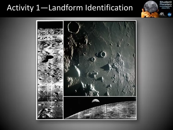
Activity 1—Landform Identification. An important part of exploration (remote sensing) is learning as much as you can about an area, region or planet. Why? Space travel is costly and dangerous. Discussion. Imagine you were going on a trip to a place you’d never been before.

E N D
An important part of exploration (remote sensing) is learning as much as you can about an area, region or planet. • Why? • Space travel is costly and dangerous
Discussion • Imagine you were going on a trip to a place you’d never been before. • Would you need to know what the land looked like? Why? • Now imagine you were going to the Moon. • Why would you need to know what the surface of the Moon is like?
What are some of the common landforms you know? • When you look at the moon, what are some features you can see? • Can you name these light and dark areas?
Procedure • For each image, identify the features you see on the numbered areas on the images • Use the “Landform Identification Sheet” to mark on the chart what features you see, indicated by the numbers on the images • Complete the chart with the remaining photographs. Be sure to use the descriptions to identify each of the features.
Highlands • Maria • Ray Review
Multi-ringed basin • Highlands • Maria
Rille • Impact Crater
Central crater uplift • Rille
Terraced Crater Walls • Central Crater Uplift
Lava Flow • Wrinkle Ridge
Dome • Rille
Ray/Crater Ejecta • Terraced Crater Wall • Central Crater Uplift
Wrap-up • Were some landforms easier to identify than others? • Did shadows help make some landforms easier to see? • Imagine you were asked to choose a landing site for a lunar vehicle. Which landform would you choose to land on or near? Why?