Download
1 / 10
100 likes | 212 Vues
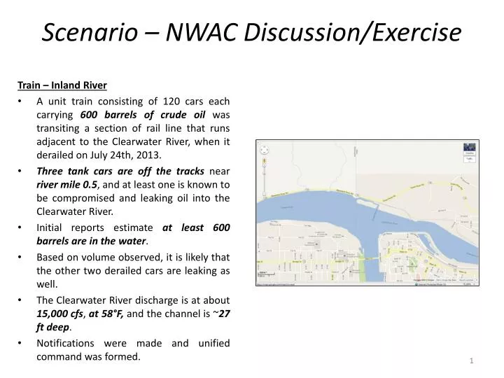
Scenario – NWAC Discussion/Exercise. Train – Inland River A unit train consisting of 120 cars each carrying 600 barrels of crude oil was transiting a section of rail line that runs adjacent to the Clearwater River, when it derailed on July 24th, 2013.

E N D
Scenario – NWAC Discussion/Exercise Train – Inland River • A unit train consisting of 120 cars each carrying 600 barrels of crude oil was transiting a section of rail line that runs adjacent to the Clearwater River, when it derailed on July 24th, 2013. • Three tank cars are off the tracks near river mile 0.5, and at least one is known to be compromised and leaking oil into the Clearwater River. • Initial reports estimate at least 600 barrels are in the water. • Based on volume observed, it is likely that the other two derailed cars are leaking as well. • The Clearwater River discharge is at about 15,000 cfs, at 58°F, and the channel is ~27 ft deep. • Notifications were made and unified command was formed.
General Waterway Layout and Commerce • A 14-foot shallow-draft channel extends 359 miles from Vancouver to Lewiston, Idaho, accommodating tugs, barges, and log rafts, worth $2.2 billion. • Port of Lewiston is part of the Columbia-Snake River System called The Inland Marine Transportation System, and it is managed by the U.S. Army Corps of Engineers. The Port of Lewiston is located at the inland terminus of the river system. It offers a sensible alternate route for shipping goods to Canada and the Midwest United States. • There are four dams on each of the rivers, totaling eight dams and locks that help vessels move upstream and downstream between the Port of Lewiston and Portland/Vancouver. These locks move vessels some 222 meters (730 vertical feet) from the coastline to the Port of Lewiston. The 4.3-meter (14-foot) river channel can accommodate loaded barges with an average 3 meters (10 feet) of draft and tugs with from 3.4 to 3.7 meters (11 to 12 feet) of draft. • This Port of Lewiston facility has five bays for rail tracks connecting to both the Union Pacific and Burlington Northern Santa Fe Railroads. Outside and inside storage is provided for paper and forest products, agricultural products, and manufactured goods. • The Port of Lewiston is connected to the Burlington Northern Santa Fe and Union Pacific Railroads.
Wildlife • Because moisture is limited in much of the lands surrounding the project area, the waters provided by the Snake River provide an important part of the food, water and cover for numerous wildlife species. • Wildlife that typically use the riparian and wetland areas associated with the project area include: • Waterfowl • Raptors • Upland game birds • Aquatic furbearers, and • Big game. • Waterfowl, raptors, and aquatic furbearers warrant special concern in the event of an oil spill in this region.
Habitat Management Units (HMUs) • In an effort to improve habitat, the Corps of Engineers has established numerous Habitat Management Units (HMUs) along the Snake River. • The HMUs established within the Lower Granite Area include (with river mile locations): • Transmission Line HMU - RM 109 • Knoxway Canyon HMU -RMI 16 • Granite Goose Pasture HMU - RM 120 • Moses HMU - RM 129 • Alpowa Creek HMU - RM 131 • Chief Timothy HMU - RM 132 • Evans Road Ponds - RM 135