Download
1 / 27
270 likes | 282 Vues
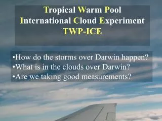
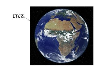
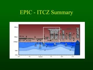
An introduction to the I nter- t ropical C onvergence Z one (ITCZ). Chia-chi Wang Dept. Atmospheric Sciences Chinese Culture University. Acknowledgment: Prof. Gudrun Magnusdottir Earth system science University of California, Irvine. ITCZ. Visible Channel (~0.65 um).

E N D
An introduction to the Inter-tropical Convergence Zone (ITCZ) Chia-chi Wang Dept. Atmospheric Sciences Chinese Culture University Acknowledgment: Prof. Gudrun Magnusdottir Earth system science University of California, Irvine
ITCZ Visible Channel (~0.65 um)
Idealized simulations of Hadley cells Northern hemisphere Summer Spring or fall pressure Contour: streamfunction Strong cell in the winter hemisphere
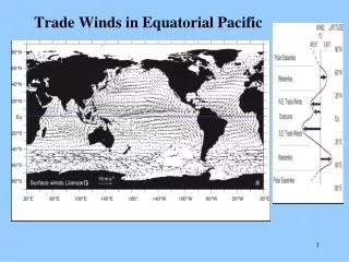
u v Climatological flow Zonal and time average of the wind field from the high resolution NCEP analysis from Aug—Oct, 2000—2002.
Climatological ITCZ Waliser and Gautier 1993. Averaged from 17 years of monthly Highly reflective cloud (HRC) data. The number of days per month the given grid point was covered by a large-scale deep convective system, subjectively determined.
The shallow meridional circulation A return flow atop the atmospheric boundary layer (ABL), around 2-4 km, in the winter hemisphere (Zhang et al. 2004)
Meridional wind & RH (Tropical Atmosphere-Ocean (TAO) ship soundings)(Zhang et al. 2004) Altitude (km) Aug.-Dec., 1995-2002, 95W-110W Altitude (km) 1-11 Nov. 2000, 95W Latitude
Some interesting topics • ITCZ tends to stay in the NH. • Double ITCZ in the eastern Pacific • South Pacific Convergence Zone (SPCZ) • East Pacific ITCZ and cold tongue complex • ITCZ breakdown • Equatorial waves (Rossby waves and Kelvin waves) v.s. ENSO • West-ward propagating disturbances (ex. Easterly waves) • Madden-Julian Oscillation (MJO) • Mesoscale processes related to cloud clusters
1988, IR Another case of ITCZ breakdown
Why is it important? • To understand the basic dynamics of the ITCZ on synoptic timescale. • An efficient way to pool vorticity in regions in the tropics which represents the early stages of tropical cyclonegenesis. • Might contribute meridional moisture transport (need more data and study). • It is an interesting topic.
Vortex roll-up simulation Horizontal heating profile Vertical heating profile Wang and Magnusdottir (2005)
- + Relative vorticity ζ
Planetary vorticity, f EQ PV = ( f + ζ) / h SP NP Potential vorticity (PV) PV is conserved when there is no friction and no diabatic heating.
Idealized simulation of ITCZ breakdown Potential Vorticity ~850 hPa PVU Barotropic instability (strong horizontal wind shear) Wang and Magnusdottir (2005)
Characteristics of the ITCZ on synoptic timescale: • The breakdown can be self-induced • The new ITCZ re-forms within a few days A strong mode of synoptic timescale lifecycle
North Eastern Pacific Phase speed = 8 m/s Longwave approximation: Non-dispersive waves u = 2.6 m/s easterly u = 0 m/s Dispersion curve for equatorial Rossby waves (n = 1) Magnusdottir and Wang 2008
Magnusdottir and Wang 2008 ITCZ composite (lag-regression between the raw vorticity data and the ITCZ index)
Summary • The ITCZ goes through stages of formation, undulation, breakdown, and dissipation on synoptic timescale. • The ITCZ is a constructive feature. It is not a group of thermal-driven convective cells lined up in a row. • A non-dispersive wave packet propagates westward in a constant phase speed.
Future work • Its vertical structure needs more study. • Wet convection in model simulation • The interaction with other phenomena (on other timescales) such as MJO and ENSO. • Mechanisms to form the ITCZ in details?
Magnusdottir and Wang 2008 25-day running variance of the filtered vorticity El Nino El Nino El Nino La Nina El Nino El Nino La Nina El Nino La Nina La Nina
An elongated convergent area induced by a weak disturbance Wang et al. 2010