Download
1 / 1
10 likes | 91 Vues
Using Market Analysis of Home Values to Measure the Economic and Fiscal Effects of Multi-Use Trails Garry Young, Andrea Sarzynski, Joseph Cordes & Hal Wolman George Washington Institute of Public Policy, George Washington University. Introduction. Do People Value Trails?.

E N D
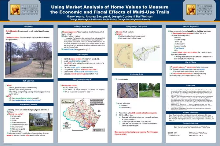
Using Market Analysis of Home Values to Measure the Economic and Fiscal Effects of Multi-Use Trails Garry Young, Andrea Sarzynski, Joseph Cordes & Hal WolmanGeorge Washington Institute of Public Policy, George Washington University Introduction Do People Value Trails? Montgomery’s Trail System Hedonic Regression Central Question: Does access to a multi-use trail boost housing values? Corollary Question: Do multi-use trails yield a net fiscal benefit to local governments? • Hedonic regression is a well established statistical technique4 • Disaggregate housing values into their “a la carte” components that vary locally: • Lot size • Square footage • Home age • School quality • Access to parks • Trail Access • Etc. • We will isolate impact of trail access, i.e., derive an actual dollar amount estimate. • Housing values based on annual MontCo assessments & sales data (MD Property View). • Do people pay more? Ceteris paribus, does trail access affect housing values? • Realtors believe it matters. • Current Ad: The house has close access to a large regional park (with tennis courts and fields); and extensive trails for runners/cyclists. The nearby Capital Crescent Trail can take you directly from the house in one direction to Bethesda or Silver Spring. Or you can take this trail the other way and go directly to Georgetown, downtown, or Arlington (where it links with the Potomac Trails). • Limited literature suggests it might.3 • 62 miles of multi-use trails • Variation • Not distributed uniformly through county • Not concentrated in affluent areas Our Study Will Identify & assess all trails in Montgomery County, MD. Locate & auditall trailaccess points. Using GIS: Overlay trails and access points onto location of all county residences. Calculate access quality for each residence. Using hedonic regression to estimate trail “value.” Determine trail construction & maintenance costs. Calculate property tax revenues derived from trails. Fiscal Effects • property values tax revenues (sans rate change) • Will estimate impact on county property revenues • Can estimate impact relative to other counties • Will estimate net fiscal benefit of trails by comparing revenue to construction and maintenance costs. Evaluating Trails Montgomery County, MD • Trail quality varies Multi-Use Trails • What? • Paved, physically separate from roadway • Minimal cross-flows by motorists • For: hiking, biking running, walking, inline skating (even cross-country skiing) • Why? • Trails promote physical activity, generally1 • Trails promote physical activity for children2 • Diverse urban county • 930,813 (2007 pop.) • 54% White, 17% African-American, 14% Asian, 14% Hispanic • 35% of households have children under 18 References • See for example Kelly R. Evenson, Amy H. Herring, Sara L. Huston. 2005. “Evaluating Change in Physical Activity with the Building of a Multi-Use Trail.” American Journal of Preventative Medicine 28(2S2): 177-185; and Reid Ewing, Tom Schmid, Richard Killingsworth, Amy Zlot, and Stephen Raudenbush. (2003). Relationship between urban sprawl and physical activity, obesity, and morbidity. American Journal of Health Promotion 18:47-57. • Jennie Yeung, Scott C. Wearing, and Andrew P. Hills, (2007) “Environmental Factors and Physical Activity in Children: Implications for Active Transport Programmes. In: Hills, Andrew P. and King, Neil A. and Byrne, Nuala M., (eds.) Children, obesity and exercise : prevention, treatment and management of childhood and adolescent obesity. Routledge, London, pp. 130-141; and James Sallis, and Karen Glanz. 2006. “The Role of Built Environments in Physical Activity, Eating, and Obesity in Childhood.” The Future of Children 16(1): 89-108. • An example is C. G., Abildso, S. Zizzi, L. C. Abildso, J. C. Steele and P. M. Gordon. (2007). “Built Environment and Psychosocial Factors Associated with Trail Proximity and Use.” American Journal of Health Behavior 31(4): 374-383. • Richard Green and Stephen Malpezzi. 2003. A Primer on U.S. Housing Markets and Housing Policy Washington, D.C.: Urban Institute Press. • Access points vary • Placement • Ease of access Why Housing Values? • Housing values reflect more than just physical attributes of the house. • What do you pay for? • School quality • Crime rates • Climate • Access to mass transit • Employment opportunities • Cultural amenities • Public service quality • Taxation levels • Isolating an amenity’s contribution to housing values gives us a gauge for how much people value something like schools. Citation Information • Researchers will audit & geocode all trail access points. • With ArcGIS we then: • Calculate walking/biking distances from each residenceto each access point. • Count major arterial crosses to access point. • Calculate best “access score” & match each residencewith its best access point. Young, Garry, Andrea Sarzynski, Joseph Cordes & Hal Wolman. 2010. Using Market Analysis of Home Values to Measure the Economic and Fiscal Effects of Multi-Use Trails.” Poster presented at the Active Living Research conference, San Diego, CA. Contact information Most research looks at just general proximity. We will measure it more precisely.