Download
1 / 30
300 likes | 439 Vues
GEOSS Task IN-05 Architecture Implementation Pilot AIP-5. Point of Contact: George Percivall Open Geospatial Consortium (OGC) March 2012. A distributed system of systems Improves coordination of strategies and observation systems

E N D
GEOSS Task IN-05 Architecture Implementation PilotAIP-5 Point of Contact: George Percivall Open Geospatial Consortium (OGC) March 2012
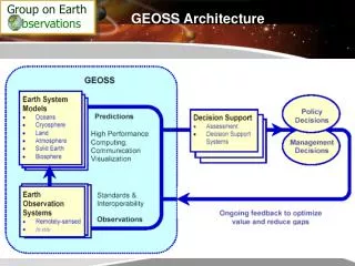
A distributed system of systems Improves coordination of strategies and observation systems Links all platforms: in situ, aircraft, and satellite networks Identifies gaps in our global capacity Facilitates exchange of data and information Improves decision-makers’ abilities to address pressing policy issues The Global Framework Global Earth Observing System Of Systems Source: Greg Withee, NOAA, OGC TC January 18, 2005
GEO Task IN-05GEOSS Design and Interoperability Related GEOSS Strategic Targets • Architecture: Deployment, population, and enablement of sustained operations and maintenance of a user-friendly and user-accessible GEOSS Common Infrastructure (GCI), including the core components and functions that link the various resources of GEOSS. Description • Manage the evolutionary technical architecture (design) of GEOSS and contributed Earth observation data and service resources. • Promote GEOSS interoperability principles. • Enable a sustainable GEOSS of value to the user – supporting the development of the GEOSS Common Infrastructure (GCI) and GEOSS communication networks for the access to, and use of, Earth observations and related services.
AIP Supports other GEO Tasks GEO Information for Societal Benefits Tasks Research Operations Requirements Research IN-05 GEOSS Design and Interoperability IN-03 GEOSS Common Infrastructure GEO Infrastructure Tasks
AIP Evolutionary Development Phases has piloted the GEOSS 10 Year Plan Architecture • AIP-1 • Kickoff: June 2007 • Result: "Core" Architecture defined most of the GCI IOC – Architecture Workshop • AIP-2 • Kickoff: September 2008 • Results: SBA implementations of common cross-cutting architecture, refined GCI concept for transition to operations • AIP-3 • Kickoff: March 2010 • Results: Enabled network building in GEOSS SBA communities, piloted broker and processing capabilities
Architecture Implementation Pilot, Phase 4 (AIP-4) Accessibility to Critical Earth Observation Priority Data Sets Thesaurus for Earth Observation Parameters Software Tools for publishing, accessing and using data Tutorials to support data providers to get data online
AIP-4 Participation (28) • Afriterra • Astrium SpotImage • CIESIN • Compusult • CREAF • enviroGRIDS • EO2HEAVEN • EOX and Rasdaman • EuroGEOSS - GENESIS • EuroGEOSS - UncertWEB • GENESI • GeoViQua, QA4EO, ESIP • GIS.FCU • Graphitech • INCOSE • INPE • Jacobs University • KNMI • Mines ParisTech • NASRDA • NOAA DMIT • NOAA & GMU • PML • PYXIS • SIF • TEAM Network • Vightel • Wash Univ St.Louis Responses to AIP-4 CFP are posted
GEOSS Infrastructure Enhancements, Dec 2011 http://www.ogcnetwork.net/pub/ogcnetwork/GEOSS/AIP4/index.html
Planning for AIP-5 • Scenario Driven Development as in AIP-3 and AIP-2 • Draft Schedule • CFP Announced: 28 February 2012 • CFP Responses due: 11 April • Kickoff Workshop, Geneva: 3-4 May • Integration begins: 1 September • Results for GEO Plenary in 2012 • AIP Plenary Telecons - 1400 UTC Tuesdays
Societal Benefit emphasis in AIP-5 • Development driven by scenarios for the SBAs: • Disasters preparedness and mitigation • Health: AQ and Waterborne • Water Resource Observations • Energy • Agriculture • Approach • “SBA Integrators” liaison between SBAs and IT • SBA Scenarios deployed through Use Cases • information technology research for SBAs, e.g. WaterML, QA and Provenance, Services
Technical Research in AIP-5 • User Management and Authentication • Support GEOSS Data CORE • Develop technical definitions for Licensing • Build on AIP-3 and existing GEO member systems • Research supporting GCI - Task IN-03 • GCI and User Management and authentication • EO Vocabulary led by Ontology Task and DIAS • Further advance Discovery and Access Brokers • Discovery of client help aplications
RM-ODP Viewpoints Community Objectives Business aspects: purpose, scope and policiesWhat for? Why? Who? When? Enterprise Viewpoint Abstract/Best Practices Information sources and models What is it about? Types of services and protocols How does each bit work? Information Viewpoint Computational Viewpoint Implementation/Development Solution optimization: distribution infrastructureHow do the components work together? Engineering Viewpoint Implementation system: hardware, software, distribution With what? Technology Viewpoint
Enterprise Viewpoint • GEOSS Strategic Vision and Targets • System of Systems approach • SBA Scenarios deployed using Tech Use Cases • Interoperability Arrangements • SBA’s in AIP-5 • Disasters preparedness and mitigation • Health: AQ and Waterborne • Water Resource Observations • Energy • Agriculture
AIP System Development Process • Scenarios: end user view of the value of GEOSS • Focused on topics of interest to a community • Occur in a geographic Area of Interest (AOI) • Steps in a scenario are mapped to Use Cases • Engineering Use Cases support SBA Scenarios • Use cases for discovery, data access, etc • Utilize Standards & Interoperability Arrangements • Reusable service oriented architecture • Leverages ‘operational domain value’ through interoperable services
GEOSS Information framework Spatial Referencing • Registries and Metadata • Data Policy, Rights Management, Licenses • Maps and Alert Messages QA, Uncertainty and Provenance Semantics and Ontologies Geophysical Observations Modelling and Data Assimilation Observations and Features
Computational Viewpoint • Service Oriented Architecture • Catalog/Registry Services • Data Access and Order Services • Processing Services and Service Chaining • Sensor Web Services • User Identity and Management Services
Engineering Components: Host data, Interact thru Services Main GEO Web Site GEOSS Common Infrastructure Registered Community Resources GEO Web Portal Client Tier Registries Community Portals Client Applications Components & Services CSW WMS Access Access Access CSW WMS WPS CSW WMS CSW Standards and Interoperability GEOSS Clearinghouse Mediation Tier CSW Best Practices Wiki Community Catalogues Workflow Management User Management Discovery Brokers User Requirements WPS WMS Portrayal Servers Processing Servers Access Brokers Test Facility EO Vocabulary Access Tier WCS WCS WCS WFS WFS WFS FTP SOS SAS SPS Order OPeNDAP GEONETCast Data Servers Sensor Web Servers Model Web Servers
GEOSS AIP Use Case Summary Discover Resources Visualize and Access Process and Automate GEOSS User Maintain and Support SoS GEOSS Resource Provider Publish Resources
Energy Scenario and Use Cases (simplified) Reference: “Energy Scenario” Engineering Report, GEO AIP-3, Lionel Menard, January 6, 2011.
Energy Scenario and Use Cases (not simplified) Reference: “Energy Scenario” Engineering Report, GEO AIP-3, Lionel Menard, January 6, 2011.
Health SBA in AIP-5 • Framework to integrate health data, environmental variables, including climate, and understandings of waterborne disease ecology. • Link environmental sensed data with health data • Integration as time series analyses • Incorporation of laboratory analysis results • Research influence of climatic and environmental variables on cholera bacterium and disease • Framework for researching simulation and prediction models for cholera outbreaks and the relationship between air pollution and adverse health effects.
Planning for AIP-5 • Scenario Driven Development as in AIP-3 and AIP-2 • Draft Schedule • CFP Announced: 28 February 2012 • CFP Responses due: 11 April • Kickoff Workshop, Geneva: 3-4 May • Integration begins: 1 September • Results for GEO Plenary in 2012 • AIP Plenary Telecons - 1400 UTC Tuesdays
References • GEO • earthobservations.org • GEO Architecture Implementation Pilot • www.ogcnetwork.net/AIpilot • GEOSS registries and SIF • geossregistries.info
Disaster Management objectives in AIP-5 • Support GEO Task DI-01 Disasters • Scenarios for a global network of in-situ observation sites for disasters preparedness and mitigation cycle. • Collaborate with CEOS WGISS GA.4. Disasters: “GEOSS Architecture for the use of Satellites for Disasters and Risk Assessment” • Mobile client for disaster response: SMS, Geosync • Space-based earth observations availability through GCI to benefit the international or regional disaster management agencies