Download
1 / 4
40 likes | 118 Vues
Visibility Analysis of Class I Areas Using Multiple Satellite Products & In-Situ Ground Based Measurements. Nikisa Jordan (1) , Jill Engel-Cox (2,1) , Raymond Hoff (1) , Kevin McCann (1) , Kamonayi Mubenga (1)

E N D
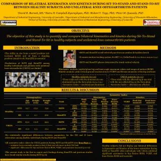
Visibility Analysis of Class I Areas Using Multiple Satellite Products & In-Situ Ground Based Measurements Nikisa Jordan(1), Jill Engel-Cox(2,1), Raymond Hoff(1), Kevin McCann(1), Kamonayi Mubenga(1) (1)CREST, Joint Center for Earth Systems Technology, University of Maryland Baltimore County, 1000 Hilltop Circle, Baltimore, MD, 21250 email: njordan1@umbc.edu (2)Battelle Memorial Institute, 2101 Wilson Boulevard, Suite 800, Arlington, VA 22201email: engelcoxj@battelle.org
Objective • Current methods & tools for studying visibility impairment involve • Ground-based back trajectory receptor models • Surface point measurements • This research offers a new approach of studying the sources of visibility degradation to Class I areas • Satellites can provide a better understanding of the pollutant source and, potentially, its concentration in protected sites. • Suites of satellite and ground-based measurements were used to provide an enhanced understanding of pollutant sources to protected areas
Data Used • In-Situ • IMPROVE surface monitors • National Park Service (NPS) Webcam images • EPA PM2.5 data was used in addition to IMPROVE aerosol data • NOAA Air Resources Laboratory (ARL) (HYbrid Single-Particle Lagrangian Integrated Trajectory) HYSPLIT model • Spaceborne • NASA MODerate Resolution Imaging Spectroradiometer (MODIS) true color images • NASA MODIS Aerosol Optical Depth (AOD) • NOAA GOES Aerosol & Smoke Product (GASP) AOD • NOAA Hazard Mapping System (HMS) Fire and Smoke Product
* Modified from Source: EPAhttp://www.epa.gov/air/visibility/monitor.html